
Worcester's Old City Walls
Sue Round
You'd never think to look at today's sprawling city of Worcester that hidden below lie the remains of its past - such remnants as the old fortified wall and eight gateways. Sections of wall, including a buttress which was part of the original St. Martin's gate can be seen along the busy City Walls Road, but much more lies under ground. Discovered sections being brought to light now and then with the building, rebuilding and alterations that is part of modern life.
Although only one of the original gateways remains - the Water Gate - the position of the other seven have been thoughtfully marked by a plaque in its appropriate place. Armed with an hour and a half, a comfortable pair of shoes and a little imagination it is possible to follow the line of the walls, to see the plaques marking each gateway, and judge for yourself the enclosure this fortified structure encircled and which current day buildings lay within.
THE FOREGATE
Beginning at the Foregate, or Forest Gate - the main entrance to the city, we begin our walk. The plaque marking this gate can be found to the left of the entrance to Berkeley's Court.
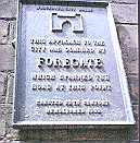
Woodland graced the area beyond the gate to the north of the city and in Tudor times cottages and small buildings lined the roadway towards the city. It is thought that most of these houses were cleared in preparation for the siege of Worcester in 1646. During the fighting a vast amount of city wall and the Foregate itself were damaged.
For many years there were cells below this gateway, which were used to house prisoners, this practice continued for some considerable time. Both gate and prison cells were finally removed sometime around 1702.
Berkeley Court is a group of Almshouses set around a courtyard, which can be seen through its wrought-iron gates. These particular Almshouses were founded by Robert Berkeley of Spetchley in 1692, and were built around 1705, on the site of a section of city wall.
Directly across from Berkeley's Court is the Hopmarket Hotel, which stands on the site of the old city gate. Parts of the original bastions of the massive gateway were uncovered when work began in the 1890s to widen Foregate Street and when the demolition of the original 18th century Hopmarket building took place.
It is interesting to note that the first poorhouse of the city also once stood on this spot. Erected in 1699, parts of the derelict city wall were used in its construction. It remained a workhouse until 1794 when the union workhouse was established on Tallow Hill.
From the Hop Market Hotel we turn right into Sansome Street; (formerly know as Town Ditch), until we reach the Worcester Arts Workshop and St. George's Roman Catholic Church.
The present church was built in 1829 on the site of an earlier chapel. Over the Altar of St. George's church is a fine copy of the picture 'The Transfiguration' by Raphael, commissioned by the 16th Earl of Shrewsbury in the 19th century.
THE TRINITY GATE
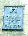
Reaching the corner of St. Nicholas Street, (formerly Gaol Lane) we arrive at the Trinity Gate and Gaol Tower.
The Trinity Gate was the site of one of the city's prisons. It was one of the smaller gateways within the wall and had a Gaol Tower, which still exist today. The plaque marking this entranceway can be found on the wall of that tower facing Queen Street…
Continuing along Queen Street, (formerly Corncheapen), where long ago Water Course Alley lay to the left. Across the busy City Walls Road can be seen what remains of Silver Street, just a few buildings now. Consisting of the Territorial
Barracks, a wine merchant and a furniture store, all occupying the site where once the old Worcester Infirmary stood.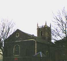 Continuing towards the Cornmarket we pass St. Martin's church, opened as a place of worship around 1772. An older church once stood on this site, and the first mention of church here dates back to 1016, although no remains of the earlier church can be found today.
The Cornmarket itself was for many years the city's principal market place. Not only was this a centre for buying and selling, but the Cornmarket was also used as a place of punishment. Both stocks and pillory have stood there in years gone by and public whippings were still being carried out well into the 19th century. In very early days it is reputed that a gallows stood on this spot.
Tucked away in the corner of the Cornmarket is part of a black and white timbered building, a further section of which can be seen just around the corner in New Street. The central part of this magnificent house having been destroyed by fire many years ago.
What is left of the building now is know as King Charles House. Built in 1577 by Richard Durrant a wealthy brewer, it was one of the most important in the city, particularly during the Civil War when Edward Durrant, grandson to Richard acted as host to Charles II.
It is reputed that from here Charles II made his escape from Worcester, leaving by a rear entrance and so out through the St. Martin's Gate to Boscobel and beyond. Above the doorway of this section of the house can be read the words…
LOVE GOD HONOUR V KINGE
ST. MARTIN'S GATE
Where the Cornmarket joins the City Walls Road is an optician's and it is on this wall that we find the plaque marking the St. Martins Gate.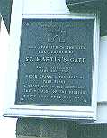 This entrance gave access to the city from the east, having two roads leading from it, the first in the direction of Lowesmore and the second to the Alcester Road.
The footing's of the St. Martin's gateway can still be identified along with parts of the city wall a short way along the City Walls Road. It is purported that it was through this gateway that Charles II made his escape during the Battle of Worcester in 1651.
This gateway in its term was finally demolished around 1773.
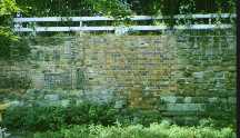
As we continue along beside the busy City Walls Road, we see clearly large section of the old city wall, including a buttress, which was part of the original St. Martin's gateway. Along this stretch are the largest sections of surviving wall.
Passing under the footbridge known as Windsor Row, we reach Nash's Passage. The entrance to almshouses, these like those at Berkeley Court were originally intended for the elderly. Nash House in New Street, (at the far end of the passage) dates from 1605 and was left by John Nash in his Will to be used for charitable purposes.
After crossing the bottom of Charles Street we reach the Friar's gate or Postern Gate…
THE FRIAR'S GATE

This small Postern gate, known as the Friar's gate stood within the city walls adjoining the old Greyfriars monastery, affording the resident Friars access to their burial ground and church, which lay just beyond the city wall. Permission for this gateway to be built was granted by King John, and its construction began in 1246.
Continuing along the City Walls Road, we see the Fownes Hotel on the
opposite side. It is interesting to note that this was once a glove-making factory.
As we reach the bottom of the City Walls Road we pass the rear of the new cinema, during its construction a section of the old city wall was unearthed along with artefacts dating back to the Romans.
Crossing at the traffic lights at the end of City Walls Road and turning left brings us into the Sidbury. There are a number of buildings of interest along here.
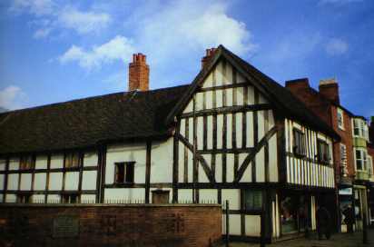
These include a black and white timber-framed building dating back to 1420, which now houses a Café. Also an old coaching inn, The King's Head, and it is on the wall of this inn that the plaque marking the site of the Sidbury gate can be found.
THE SIDBURY GATE
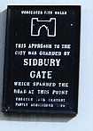
The great Sidbury gate or London gate gave access to the city from the south. This gate was stormed by parliamentary troops during the onslaught of the battle of Worcester in 1651. Down from Fort Royal Hill, (a military stronghold) the invading marauders came, past the Commandery and on to the gate. Sadly it was beside this gateway that more than 1,000 Scottish Soldiers lost their lives during the fighting to defend the city.
It is said that this is the entranceway in which Charles II fleeing his pursuers was able to enter the safety of the city during the raging battles. The story tells of how Charles was helped by the cunning of a young man with a loaded cart placed strategically beside the gateway, thus allowing Charles to enter undetected.
Along with any remaining wall this gateway was demolished sometime during 1768 when the canal and locks were being constructed.
As we reach the Canal Bridge, even though not part of the old fortified city it is well worth while to note the plaque erected in 1993 by the Cromwell Association and the City Council to denote that the last battle of the English Civil War was fought in Worcester.
THE COMMANDERY
Beside the canal bridge is the Commandery. Lying just outside the city wall and on the site of what was during the 11th century a hospital founded by Bishop Wulstan. One of four medical sites in the city giving convenient shelter for those travellers who did not reach the gateway until after curfew. Unfortunately none of this early building survives.
It was during the 13th century that the building first became known as The Commandery. Much work was carried out on it during the 15th century with additions and additional work being carried out of the later years.
During the 16th century The Commandery was the home of the Wilde Family, being first acquired by Thomas Wilde, High Bailiff and Alderman of the city. The house then passed to his son Robert, and his son (also Robert) who was an officer of the Royalist Garrison.
During the Civil War the Commandery became the headquarters of the Royalist Forces and it was here after being wounded during the fighting that the Duke of Hamilton died.
Over the years The Commandery has been used for a number of purposes, first being sold to the Dandridge family in 1764, later it became home to the Worcester College for the Blind, and after that a Literary Print Works. Today it houses an excellent Museum of the English Civil War.
For safety reasons it is better to cross over the Sidbury at this point where there are traffic lights to assist. We then continue along St. Peter's Street following its direction as it becomes King Street, taking us in the direction of Severn Street. However before turning left into Severn Street it is well worth pausing to take a look at the Edgar Tower.
Turn right and head towards the corner of Edgar Street where this gateway can be seen in all its glory leading into the Cathedral Precinct and gardens.
EDGAR TOWER
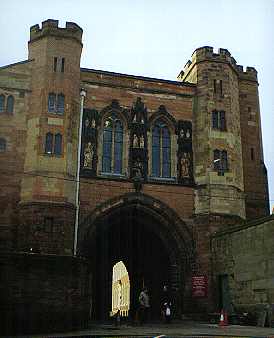
A gateway has stood on this spot since early times. Built during the 1200s by the order of King John, this existing gateway once gave access not only to the Cathedral and monastery, but also to the Castle grounds used by the Garrison, and prior to that an earlier structure giving entry to the Roman encampment.
This gateway still has its original wooden gates, although originally know as St. Mary's gate it was changed as for centuries the figure of King Edgar looked down upon anyone who passed through. Edgar an early English king was carved by the order of St. Oswald in 973, sadly this effigy crumbled to dust.
However in 1910 when restoration work was being done on the gateway and tower an exact copy was carved into the façade.
Retracing our steps to the junction at King street we resume our walk along the line of the old city wall down Severn Street, (formerly Frog Lane), towards the Frog Gate, passing the Royal Worcester Porcelain Works. The plaque marking the position of the Frog Gate can be found on the wall of this building just before the entrance to the porcelain museum.
The Royal Worcester Porcelain Works is one of Britain's oldest continuous producers of porcelain. A visitor's centre housed in the building gives ample opportunity to learn about Royal Worcester's past and present.
FROG GATE AND CASTLE
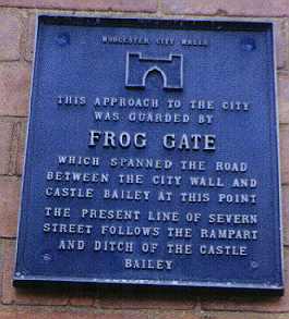
This, the smallest of the gateways spanned the road at this point between the city wall and the castle bailey. It's interesting to note that the present line of Severn Street follows what was once the rampart and ditch of the castle.
We now continue down Severn Street towards the river. It was close to here that Worcester's castle fortress once stood. The first castle being built shortly after the Norman Conquest. Constructed firstly in timber then in stone. Its location to the river made an excellent defence point.
In the 11th century Sheriff Urso built his castle, encroaching on the grounds to the south side of the cathedral, and extending the wall encircling both castle and monastery down to the river, his aim no doubt to create a fortress of some strength.
His defence wall ran along what is now Severn Street, around by the Edgar Tower and back to the river again via Walmstry Slip.
After Urso's death King John returned the lands taken from the cathedral and monastery back to the monks. The King then took over custody of the castle, and for many years it was used as a residence for visiting royalty. This accounts no doubt for the restoration of the Edgar Tower, providing a splendid entranceway to the castle grounds.
Finally the castle was handed over to the Shire Authorities to be used as a prison. When a new prison was built in Salt Lane, later changed to the now more familiar Castle Street, the old castle was demolished.
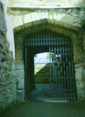
Following along this road we pass building belonging to the King's School. These occupy the site of the old castle grounds, some medieval wall can still be seen as we head towards the river and the only surviving gateway, the Watergate. Which upon reaching the river can be found a short way along to the right.
THE WATER GATE
A sandstone structure with Portcullis and double gates, this entranceway afforded access directly to the river Severn from the cathedral and monastery grounds. It was built by William Poer, the cathedral cellerar in 1378.
There is an interesting curio inside the gateway. Etched into the brickwork is the shape of a sturgeon - (just above ground level on the right hand side) - the outline of the fish caught further down river at Diglis.
A ferry crossed the river at this point; the Priory ferry or Cathedral ferry as it was known worked regularly until the mid-twentieth century. Although even today during the summer months on occasional weekends or bank holidays the ferry does operate across the river manned by volunteers.
THE RIVER SEVERN
From this point on there was no need for a defending wall as the river itself formed a natural barrier. The Severn is the longest river in England - 220miles - and was a natural place for a settlement.
The river Severn derives its name from the legendary figure Sabrina, innocent young princess put to death by drowning in the Dark Ages. The oldest reported tale of 'the legend of Sabrina' can be found in books denoting tales of the 12th century.
Sabrina, the Latin form of the old English word Sabren, was later corrupted into Severn.
From time to time the river is apt to flood, one such occasion occurred in 1866 when the water almost reached the crown of the bridge arches. On the wall beside the Water Gate where the flood levels are recorded, 1947 seems to have been a bad year, along with 1770 and 1672, and more recent the year 2000.
We continue along the riverside walkway known as Kleve Walk, so named for Worcester's twin town in Germany.
A considerable amount of ancient walls is visible along her, walls that once surrounded the Cathedral and its Monastic buildings, which now protects the Cathedral gardens.
This pathway that is reputed to have been build upon sunken barges sometime after 1833.
As we stroll beside the river we pass what is known locally as The Glovers Needle. This tower and spire is all that remains of St. Andrew's church.
ST ANDREW'S CHURCH
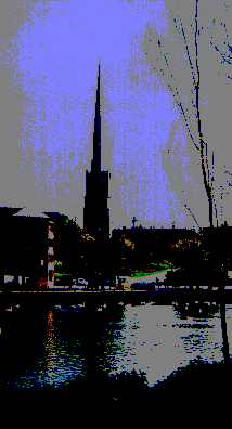
The Glover's Needle is the last remains of St. Andrew's church. Built in 1751 to a height of at least 155 feet, the needle dominates this particular bit of the skyline.
There has long been a church on this site, one of which was built around the 12th century and serves as a parish church of the city. Records show that there has been a church on this site as early as 1066.
St. Andrew's was demolished during the final stages of the slum clearances in the area during the late 1940s. Leaving the spire or Glovers Needle as a permanent reminder of its importance to the early life of the city.
Beside the river walkway we can see the Millennium Fountain. Under lit to give maximum effect, this water feature, a project constructed to celebrate the year 2000, (the second millennium) brings an added dimension to the riverside.
Passing the Walmstry Slip an area that still has evidence of the trading that used to take place beside the river. Warehouses once used for wine, cloth and the many other goods exported to and from the city, stand as a timely reminder of trading days gone by.
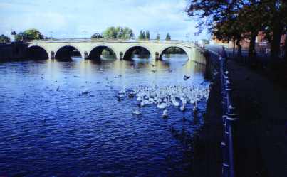
Crossing over Bridge Street, with the city bridge to our left, we reach the South Quay. It is here, where the steps go down to the lower walkway we find the plaque marking the spot of the old City Bridge and the Bridge Gate.
THE BRIDGE GATE
On this site, north of the present bridge, stood the old bridge and gatehouse. Originally a wooden structure which gave access across the river Severn into Wales.
In 1313 the then Prior of Worcester raised funds for a stone bridge, which was erected soon after. A gatehouse stood on its centre, serving as the Bridge Gate and was closed beside a small entranceway known as St. Clement's Gate. Finally after many years of service both bridge and gatehouse were demolished in the second half of the 18th century.
Having taken the decision to move the site of a bridge, the foundation stone of the new bridge - on the site of the current one - was laid in 1771. A new approach road, Bridge Street was also constructed to link with the bridge, and with it the building of the Quays, this transformed the riverside frontage. It was in 1932 that this bridge was dismantled to make way for the present one.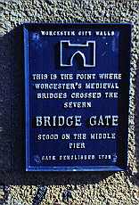 A little further along the walkway from the site of the plaque marking the site of the old bridge pleasure gardens flank the Severn, affording a enjoyable walk and a sight of the many boats that frequently travel along this stretch of the river.
To complete our circuit of the old boundary we cross over the North Quay into Dolday. Directly in front of us is the rear entrance to the Crowngate Shopping Centre and the bus station.
BLACKFRIARS
The shopping centre and bus station stand on the site once occupied by the Blackfriars Priory. These Dominican monks arrived in Worcester around 1347. During the reformation in the 16th century most of the building occupied by them was destroyed, eventually disappearing altogether by the end of the 18th century when a great many houses were crammed onto the site. Most of which were demolished during the slum clearances of the 19th century.
In the 1970s a Shopping centre aptly named the 'Blackfriars' stood on the site. This in its turn was demolished to make way for the existing Crowngate complex, leaving no trace of the former Priory buildings.
We follow the road as it curves into The Butts. Situated just outside the old boundary of the wall, The Butts was an area used for archery practice, hence its name.
An underground culvert carries the stream that once wended if way along at this point, entering the river Severn close to where the Railway Bridge now.
When this section of the wall was demolished houses were built on the foundations.
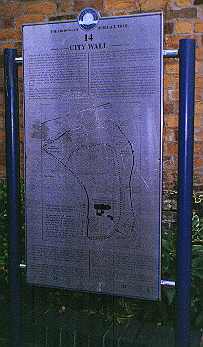
Continuing along The Butts we pass a narrow passageway, Rack Alley, so named for its association with the cloth trade. This narrow alleyway passes directly over the site of the old wall. At the top of these steps to the left, there is a map showing the old city walls, closely outlining the walk we have undertaken.
Resuming our walk and crossing the bottom of Angel Place - the site of a daily market - we see the former Congregational Church on the corner. This church was built around 1859 and was capable of holding approximately one thousand people. During the mid 1980s it became the night-club it is today.
Finally as we continue up The Butts, and pass the Five Ways Hotel we enter Shaw Street, (formerly Gardener's Lane). Shaw Street along with The Butts formed the ditch just outside the wall.
This brings us full circle into Foregate Street and the great Fore Gate once more.
EPILOGUE
Our tour of the old city boundary is now complete. In centuries past we may well have found ourselves in the company of our illustrious ancestors as each year on St. John's Eve, 23rd June, an inspection of the walls was carried out. And just as might happen today this ceremony quickly developed into a holiday and feast, allowing the citizens of that time a days break from their various tasks.
Interestingly in 1913 the then Mayor of Worcester invited citizens to join him on a tour around the boundary of the city.
As with our walk there is much of old Worcester that can be enjoyed today, you only have to walk along New Street or Friar Street to see the medieval buildings that have survived.
A FINAL WORD ON SAFETY…
It is important to note, that it is inadvisable to undertake this walk around the old city walls if the river level is high, as the footpaths beside it are likely to be under water.