
In this article I shall try to put together a sketch of life and society in the iron age by studying the archaeology of the settlement of Beckford that lay on the south side of Bredon Hill in Worcestershire. Using what is known of the period I shall try to place the village within the wider landscape and consider its possible connections to other sites in the area.
Most of the details of the discoveries made at the Beckford site during its excavation prior to gravel quarrying between 1972 and 1979 are taken from a lecture given by James Dinn.(1)Sadly, full publication of the excavations is still not forthcoming, so I'm passing on what I can - all mistakes should be attributed to me!
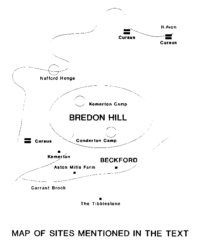
Near to Beckford, there have been important finds of acheulean flints and handaxes from the lower and middle palaeolithic periods.(2) Bredon Hill has yielded some neolithic imports, a dolerite axe from Brittany, and a jadeite axe from northern Italy or Switzerland (both high status objects)(3); and a general scatter of neolithic finds supports some form of presence in the neolithic, although no firm evidence exists for a settlement.(4) Brian Hoggard also reports a possible long barrow in the parish of Bredon Norton, and crop marks visible from the air that suggest three cursus sites by the river Avon and a henge at Nafford.(5)
The base of an early bronze age barrow (ploughed out) was found in excavations at another iron age settlement at Aston Mills farm, and aerial photography has revealed crop marks of other round barrows and associated enclosures. In 1905 a bronze age enclosure was discovered at Kemerton(6) and, in 1999, Channel 4's Time Team found evidence of bronze age and iron age settlement here. On Bredon Hill, early cast bronze Beaker axes have been found as well as Beaker burials of a man around 50 and a woman of about 30 years old. The skeletons were found in a central pit under a small round barrow along with two middle period beakers, four barbed and tanged flint arrowheads, a flint knife and a bone spatula.(7) At Beckford itself, bronze age finds include a rare bronze barbed and tanged arrowhead, and an early bronze age razor mound. A mid-bronze age ditch (circa 1400 BCE) and late bronze age linear ditches running perpendicular to the Carrant Brook have been found (8), suggesting typical changes in agricultural techniques of this period. Improved technology such as the plough allowed for more efficient farming of smaller areas than before, and smaller, perhaps family based, groups could create more permanent settlements than in the neolithic. The result was that the landscape becomes more fragmented and enclosed by earthworks and domestic evidence becomes more common, and homes and settlements begin to seem to take over from large communal monuments as ways of affirming identity and belonging with the environment.(9) There was certainly a bronze age settlement (or settlements) at the site of the iron age village (a little to the east of the present village).
One other possible bronze age site is the Tibblestone near the Teddington Hands crossroads around two miles to the south west. This monolith was only rediscovered in 1848 and was re-erected by the old crossroads probably according to details from old maps, or maybe just where it turned up when a man was digging foundations.(10) Its date must be doubtful as well as its original position. In years gone by, it served as a boundary stone, and I shall use it as marking the southern extent of our area. The scatter of iron age hill forts south of here on the edge of the Cotswolds will be assumed to be not directly linked to Beckford and the Bredon Hill sites (although they would be visible from the Bredon Hill forts and possibly trade existed between them).
 It is in the iron age that Bredon Hill and its environs seem to have had their heyday. The hill contains two definite hillforts, Conderton Camp and the larger Kemerton Camp (which contains the Banbury or Bambury Stone). On the north eastern slopes, there is probably another beneath the site of Elmley Castle. I shall be discussing these sites shortly with regards to their possible links with Beckford. West of Beckford was another settlement at Aston Mills Farm which seems to have been a looser scatter of farmsteads and fields, whereas Beckford was a full blown village with several hundred inhabitants.(11)
The site would seem to be a cluster of compounds that were nuclei for smaller family groups. There were around fifty round houses, some surrounded by ditches and some not. The ditches may have been for drainage or maybe keeping animals out. The houses would have been wooden or wattle and daub, with thatched roofs. Some houses contained clay lined pits, around eighteen inches in diameter, containing burnt stones, almost certainly for boiling water. One of the house sites still had its stone floor intact, complete with clay hearth and a stone lined oven sunk in the floor. This house had been occupied over a 300 year period, and had been rebuilt at least six times. Mostly, however, the excavators had to make do with evidence from below the iron age ground level meaning that many details of the houses are unknown. From other sites we can assume that the houses probably only had one entrance, and there may have been symbolism inherent in its orientation - the majority of houses of this period have their entrances facing east, with a tendency to be orientated towards the rising sun at midwinter or the equinoxes.(12) To orientate the home with the cycles of the sun can be seen as a symbolic way of building a sense of belonging between people and their environment, as I have discussed elsewhere.(13)
Associated with particular houses were groups of pits. There were over a thousand of these pits up to two and a half metres deep. These were used for storing grain that was grown in the surrounding fields (carbonised wheat, oats, and barley were found), and the large number can be accounted for by new ones being dug when others fell out of use. An air-tight seal (such as a large stone or wooden cover) would have been necessary, to stop the grain from rotting. If the grain got wet or air got in, the grain would have rotted. Once damp grain starts to rot, the fungi and bacteria can contaminate the pit, making it unusable.(14) Once no longer in use domestic waste was dumped in the pits, and new ones dug.
There were also some other structures on the site. Post holes of rectangular buildings were discovered. These may be the same type of building, found elsewhere in this period, as those that are raised above the ground and supported on posts. These post-built structures are usually described as granaries.(15) A kiln was found, showing the villagers made their own pottery (although some was brought in from the Malvern area). The discovery of loom weights shows they weaved clothing on site. The Beckford folk also worked metal in the village. A crucible for melting copper ore was discovered, also evidence of iron smelting and casting in bronze. Binns comments that although the village would appear to be a low status site, their craftsmen produced some high status goods. This suggests that perhaps they produced for the nearby hillfort dwellers, as well as for themselves. Economic links are firmly suggested by the find of ten currency bars in a pit. These were standardised iron ingots usually only found in hillfort sites and probably not a form of currency at all.(16) It seems likely that they were produced in working settlements and sent up to the hillforts where the ingots could be forged into tools and weapons.(17) Whether the grain the villagers grew or the animals they kept (they probably kept sheep, cattle and pigs(18)) were also traded to, or produced for, the hillforts is unknown.
Before considering the hillforts themselves, I shall briefly mention some more mysterious structures that perhaps have links to ritual behaviour. There is a large oval enclosure which is made up of around fifty concentric oval ditches - what it could be is a complete mystery. Maybe it has some relation to the (earlier) structure recently discovered by a geophysical survey within the great circle at Stanton Drew - here nine concentric rings of ditches were found that probably was once a ritual wooden structure (19). There is also a stone covered yard which was surrounded by posts. Large postholes and a path show that the entrance to this enclosed area was quite elaborate. Animal bones and pottery were found towards the rear of the yard area - sacrifice or ritual feasting perhaps took place here.
Whilst of the subject of ritual, what happened to the dead? Only a handful of burials were discovered, but several hundred people lived here for around 300 years. Of the few skeletons that were found, most were in the backfills of ditches. One man had a partially healed sword wound on the top of his skull, but there is no real evidence of violence.
There is also no sign of violence associated with the abandonment of the site either (although Kemerton Camp was the site of a massacre). Maybe the village moved to the site of the present day Beckford perhaps because they ran out of room to dig any more storage pits! All we know is that a large village was abandoned after 300 years in a relatively short time.
Conderton is the smaller of these hillforts, and was originally a cattle enclosure.(20) Although originally dated later, both this fort and Kemerton Camp are thought to have come into use at a similar time to Beckford.(21) All three sites would have been in use during the same period. The cattle enclosure was protected by a bank and ditch and by a slight counterscarp on the east and west of the site. A bank faced with drystone walling was built later within the camp to cut off the weak northern side of this triangular fort. A village of huts was then built within this northern section, whilst the rest was probably still used to keep livestock.(22) The two sections both have inturned entrances as will be discussed later.
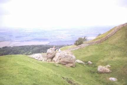
Kemerton Camp is larger and, I suspect, the most important to the society of the middle iron age. It encloses 22 acres and is situated right on the summit of Bredon Hill.(23) It also contains stone foundations of circular huts.(24) Begun in the early iron age, boasting a stone faced rampart and external U-shaped ditch, it was refurbished in the mid iron age in the glacis style (piled up earth and rubble).(25) Both sets of ramparts have inturned entrances. Originally, the inner enclosure was thought to be earlier, with the extended outer ramparts added later, but now archaeologists tend to favour the outer section as being the earliest.(26) So it was not extended, as was thought. So why the inner enclosure? A second line of defence or something completely different, as the Monty Python team would say? I favour the latter option.
Traditional views of the function of hillforts is that they were primarily the strongholds of powerful tribal chiefs, with the general surrounding population only entering in times of war. Kemerton might fit this bill, with the lesser hilltop enclosures providing home for the lesser nobles, and the general population of farmers and craftsmen living in places like Beckford.(27) However, the prevailing opinion amongst archaeologists is beginning to change. Many hillforts contained large populations, and were more like secure hilltop villages, and contained central shrines or pits for ritual 'totem poles', suggesting a role of being more of a socio-religious centre than an expression of power politics and warfare.(28) This seems to have become the case in many places by the mid iron age when such developed hillforts:
"..don't show signs of warfare such as can been seen in early forts ... It has been suggested that by mid iron age times warfare had become highly formalised, with individual champions fighting for the honour of a community rather than open warfare between groups."(29)Okay, so Kemerton Camp was eventually attacked and razed by invading Belgic warriors, after which it was abandoned. This, however, doesn't invalidate the point that such hillforts were not solely, or even primarily, military forts. Children and Nash, for example, argue that hillforts acted as symbolic focal points and meeting places for the inhabitants of the surrounding land. They were thus positioned in order to be visible to the people.(30) This may be due to changes in political organisation, and be a means of giving communities spread over wide areas a sense of common identity and belonging within their environment.(31) As Children and Nash explain:
"The visuality of hillforts was enhanced by their elevated positioning within the landscape. Elevated sites were chosen, not so much for reasons of defence, as to establish a relationship of intervisibility. Hillfort communities within sight of each other would have shared a common socio- political identity as well as a sense of collective well-being."(32)Kemerton Camp and British Camp on the Malverns were certainly intervisible, and you can probably (I'm not sure) see the large Cotswold hillfort of Nottingham Hill from Kemerton Camp. Brian Hoggard has noted that from the Banbury Stone in the inner enclosure of Kemerton Camp the sun sets over British Camp at the equinoxes. This may have signified trade and social links (pottery from Malvern was found at Beckford), as well as cosmological principles. The Banbury stone is a natural outcrop, but may have been used to set the hillfort around for just this reason.(33) Maybe the inner enclosure was created to stress the sanctity of this stone, it was certainly revered in folk custom in later days.
By the middle iron age, when Kemerton Camp was probably remodelled, the eastern orientation of roundhouse doorways within hillforts tended to disappear, with doorways now facing the centre of the hillfort. Thus, "the hillfort was now the referent, the axis mundi".(34) Within Kemerton Camp, the Banbury stone may well have been the symbol of this cosmological principle. Folklore claims that the stone has a tendency to travel down to the Avon for a drink at certain times. Such moving stone stories are thought to have developed from an idea of stones simply turning (35), and remind me of the idea of a spinning central axis. Nearby is a Saint Catherine's Well, which is reminiscent of similar ideas:
"This is St. Catherine who is always portrayed with a wheel, the instrument of her martyrdom. But rotating wheels, the axis mundi, seem to resonate with omphali associations."(36)So, it seems that not only was Bredon Hill and Kemerton Camp in particular a focus for the community, but the inner enclosure seems to have been set aside as a sacred focus, reflecting a fusion of cosmological time and space. The inturned entrances too, may have been designed to stress the importance of entering such a special area, as some of the Beckford folk may have done at seasonal festivals:
"Staggering the entrance or extending the passage to form an inturned entrance, as at Bredon Hill ... were further devices intended to exert physical and psychological control, the individual or group seeking entry remaining contained and observable within the liminal space of the entrance for as long as possible."(37)A Beckford farmer, perhaps arriving to celebrate a successful harvest, would have been suitably awed by entering such a place. He would have felt a real sense of occasion and honour to be allowed within this hallowed area - the centre of the world in his eyes.
(2) Timothy Darvill, Prehistoric Gloucestershire, Alan Sutton, 1987
(3)Timothy Darvill, Prehistoric Gloucestershire, Alan Sutton, 1987
(4) Binns, op.cit.
(5) Brian Hoggard, "When is a Rock Not Just a Rock? A Case study of Two Sites on Bredon Hill", 3rd Stone 28, 1997
(6) Binns, op.cit.
(7) Darvill, op.cit.
(8) Binns, op.cit.
(9) John C.Barrett, "Defining Domestic Space in the Bronze Age of Southern Britain", Architecture & Order (Eds. M.Parker Pearson & C.Richards), Routledge, 1994
(10) Danny Sullivan, The Old Stones of Gloucestershire, Reardon & Son, 1991
(11) Binns, op.cit. In the following section Binns is the source for everything except when I cite another source.
(12) Mike Parker Pearson & Colin Richards, "Architecture and Order: Spatial Representation and Archaeology", Architecture & Order, Routledge, 1994
(13) Liam Rogers, "Glass Houses", The Ley Hunter 130, 1998
(14) Barry Cunliffe, Danebury, Batsford/English Heritage, 1993
(15) Barry Cunliffe, Danebury, Batsford/English Heritage, 1993
(16) Darvill, op.cit.
(17) Cunliffe, op.cit.
(18) David Lloyd, A History of Worcestershire, Phillimore, 1993
(19) Stanton Drew Stone Circles, English Heritage Site Leaflet
(20) K.S.Painter, Regional Archaeologies: The Severn Basin, Heineman, 1967
(21) Lloyd, op.cit.
(22) Painter, op.cit.
(23) ibid
(24) George Children & George Nash, Prehistoric Sites of Herefordshire, Logaston, 1994
(25) Darvill, op.cit.
(26) Lloyd, op.cit.
(27) Cunliffe, op.cit.
(28) Ann Woodward, Shrines & Sacrifice, Batsford/English Heritage, 1992
(29) Darvill, op.cit.
(30) George Children & George Nash, "Encoding Space: The Iron Age of South-East Wales - A Question of Defence or Social Statementing", 3rd Stone 25, 1997
(31) Parker Pearson & Richards, op.cit.
(32) Children and Nash, 1997, op.cit.
(33) Brian Hoggard, "Dead Sunny", The Ley Hunter 125, 1996
(34) Parker Pearson & Richards, op.cit.
(35) Samuel Pyeatt Menefee, "Megalithic Movement: A Study of Thresholds in Time", Boundaries & Thresholds (Ed. H.E.Davidson), Thimble Press, 1993
(36) Bob Trubshaw, The Quest for the Omphalos, Heart of Albion Press, 1991
(37) George Children & George Nash, "Rites of Passage and the Cultural Life of the Doorway: An Expression in Metaphor and Social Statementing", 3rd Stone 29, 1998
Acheulean: Early type of flaked stone tools. Axes, scrapers, and cleavers that were simple in design named after 300,000 finds from St Acheul in France.
Axis Mundi: Literally "the axis of the world", an archaic concept of a metaphysical point around which the world or cosmos turns. Related to the omphalos - the navel or centre of the world - where the realms of the gods are deemed to interact with our world.
Barrow: A burial mound. Long barrows are elongated, often containing a central passage with side chambers, and date to the neolithic period. Round barrows are roughly circular and date to the bronze age.
Beaker: A distinctive decorated drinking vessel associated with early bronze age burials. The culture responsible for such burials are known as the Beaker Folk, and probably came from the continent.
Bronze Age: Coming after the neolithic period, this is the period where the use of bronze is evidenced. In Britain, around 1600-800 BC.
Counterscarp: A natural steep drop, say from a hillfort, which makes defensive banks amd ditches unneccessary.
Cursus: A long linear feature comprising of two parallel banks, dating from the earlier neolithic. They tend to lead towards water, and are associated with later henges and funerary monuments. No one is completely sure of their function but they may have been processional ways associated with funerary rites or ancestor worship.
Henge: A mid-neolithic ritual site. A roughly circular area enclosed by a bank and ditch. Unlike other "defensive" sites, the bank is outside the ditch. Sometimes have (later neolithic) stone circles set within them, but this is the exception rather than the rule.
Hillfort: A (usually) iron age banked and ditched area often commanding extensive views upon a hilltop. Usually contain houses and other structures, they are fortified hilltop villages probably run by chieftains who control the local area and its inhabitants.
Iron Age: Period in which the use of iron tends to take over from bronze. Roughly 800 BC until the Roman invasion of 43 AD.
Neolithic: "New Stone Age" in which large permanent structures built of stone appear, and farming appears to take over from hunting and gathering. In this area, roughly 3500-1600 BC.
Palaeolithic: "Old Stone Age" subdivided into three periods, roughly: Lower (500,000-200,000 BC), Middle (200,000-35,000), and Upper (35,000-10,000 BC). The Palaeolithic is followed by the Mesolithic ("Middle Stone Age"), roughly 10,000-3,500 BC.