|
Location:
|
|
|
Western Region, 100km West of Pokhara.
|
|
Route:
|
|
|
Baglung - Gurja Gaun - Budzunga Bara
- Dhorpatan - Baglung
|
|
Map:
|
|
|
"Pokhara to round Dhaulagiri Himal", Mandala Trekking Maps.
|
|
Season:
|
|
|
October -
April
|
|
Days:
|
|
|
11
|
|
Equipment:
|
|
|
As for Dhaulagiri Base Camp.
|
|
Permits |
|
|
Dhorpatan National Park
permit. |
|
Images |
|
|
Photo gallery |
 This account describes an
attempt by myself and Jim Colchester to reach the Churren Himal base camp in the western
Dhaulagiri range in October 1997. Despite having to abort our attempt to reach the base
camp (owing to bad weather caused by the El Nino effect) the trek was both scenic and
challenging. Like the Dhaulagiri base camp trek, this route takes you into remote and
uninhabited country and has the added benefit that it is much less frequently travelled by
tourists. There are few tourist guest houses and English is scarcely spoken anywhere on
the route. There are some lodges up to Dhorpatan but en route to Gurja Gaun you have to
stay with villagers or camp. Thus unless you are a Nepali speaker or are confident with
hand signs, it might be advisable to take a guide. Remember to add at least one further
day to our trek to reach the base camp. This account describes an
attempt by myself and Jim Colchester to reach the Churren Himal base camp in the western
Dhaulagiri range in October 1997. Despite having to abort our attempt to reach the base
camp (owing to bad weather caused by the El Nino effect) the trek was both scenic and
challenging. Like the Dhaulagiri base camp trek, this route takes you into remote and
uninhabited country and has the added benefit that it is much less frequently travelled by
tourists. There are few tourist guest houses and English is scarcely spoken anywhere on
the route. There are some lodges up to Dhorpatan but en route to Gurja Gaun you have to
stay with villagers or camp. Thus unless you are a Nepali speaker or are confident with
hand signs, it might be advisable to take a guide. Remember to add at least one further
day to our trek to reach the base camp.
 The paths on this trek were good and altitude sickness is less likely to be a problem
(compared with Dhaulagiri) as there is no real need to camp at high altitude. Our return
route from Dhorpatan to Baglung is a day longer than going back via Darbang and less
scenic in terms of mountain views. It does however make for a circuitous trek
and it is
possible to continue south from Kharbang to Tamghas (1½ days), from where a bus to Tansen
is available, rather than returning to Baglung . Other alternative approach and exit
points for this trek include Jomosom via Dhaulagiri Base Camp (approx 9 days) or Dunai (in Dolpo District) via Dhorpatan (3-4 days). The paths on this trek were good and altitude sickness is less likely to be a problem
(compared with Dhaulagiri) as there is no real need to camp at high altitude. Our return
route from Dhorpatan to Baglung is a day longer than going back via Darbang and less
scenic in terms of mountain views. It does however make for a circuitous trek
and it is
possible to continue south from Kharbang to Tamghas (1½ days), from where a bus to Tansen
is available, rather than returning to Baglung . Other alternative approach and exit
points for this trek include Jomosom via Dhaulagiri Base Camp (approx 9 days) or Dunai (in Dolpo District) via Dhorpatan (3-4 days).
Please be aware that this account is based on personal experiences of trekking in
October 1997 and is not intended to be an authoritative guide. Conditions on the trail may
have changed and I advise anyone wanting to make the trek to consult a professional
trekking agency before setting off. During the Maoist insurgency
which took place between 1996 and 2006, many western districts, including Baglung,
were not considered safe for westerners to visit (see box below). Now that
the insurgency is over and the Maoist cadres integrated into the Nepalese
Army, there should be absolutely no risk of any problems.
 The Maoist insurgency
which started in 1996 as an internal uprising had by 2001 descended
into full blown civil war intent on ridding Nepal of its
constitutional monarchy by undemocratic means of force and
intimidation. During the 10 years of conflict, it is estimated that over 15,000
were killed, mostly rebels, army and police. The districts of Rolpa and Rukum which adjoin Baglung's western border
were
particular black spots and the trouble spread into Baglung and Myagdi. The countryside area beyond the district headquarters
was
predominantly under Maoist control and even the headquarters were not safe as the bloody attack on Beni in 2004 proved.
The
Maoists were not violent towards western tourists, but donations
to the cause were often extorted from trekkers, sometimes even at
gun point! The Maoist insurgency
which started in 1996 as an internal uprising had by 2001 descended
into full blown civil war intent on ridding Nepal of its
constitutional monarchy by undemocratic means of force and
intimidation. During the 10 years of conflict, it is estimated that over 15,000
were killed, mostly rebels, army and police. The districts of Rolpa and Rukum which adjoin Baglung's western border
were
particular black spots and the trouble spread into Baglung and Myagdi. The countryside area beyond the district headquarters
was
predominantly under Maoist control and even the headquarters were not safe as the bloody attack on Beni in 2004 proved.
The
Maoists were not violent towards western tourists, but donations
to the cause were often extorted from trekkers, sometimes even at
gun point! |
Day 1: Baglung - Darbang
 This is a long first day, even if you decide, as we did, to take the truck up the new
road to Beni. We used Baglung as our starting point simply because it has
nostalgic importance to me. In all truth there's not much to interest the foreign tourist here and it can
be avoided unless you arrive late and need somewhere to spend the night before an early
start. If staying, "Hill View", "Jyoti" or "Peace Palace" hotels are the best options.
Buses from Kathamndu or Pokhara to Beni, bypass Baglung altogether
continuing up the kali Gandaki from Maaldhunga, a few kilometres short of Baglung, where the bridge crosses the Kali Gandaki.
Before these regular services you either had to walk to Beni (2½-3 hours) or
take a jeep (1 hour). This is a long first day, even if you decide, as we did, to take the truck up the new
road to Beni. We used Baglung as our starting point simply because it has
nostalgic importance to me. In all truth there's not much to interest the foreign tourist here and it can
be avoided unless you arrive late and need somewhere to spend the night before an early
start. If staying, "Hill View", "Jyoti" or "Peace Palace" hotels are the best options.
Buses from Kathamndu or Pokhara to Beni, bypass Baglung altogether
continuing up the kali Gandaki from Maaldhunga, a few kilometres short of Baglung, where the bridge crosses the Kali Gandaki.
Before these regular services you either had to walk to Beni (2½-3 hours) or
take a jeep (1 hour).
 Neither of the 2 road extensions to Beni
had been surfaced by 2011 (see info box
below) so vehicular access is dependent upon the weather and
landslides although the lower road seems to have few issues. From Beni it's
still a 7-8 hour walk up the Myagdi Khola to Darbang so staying overnight here is an
attractive option. Good hotels in Beni were the "Yeti" or "Dolphin". En route to Darbang,
you can get daal bhaat and noodles at Tatopani and Babichor. In Darbang itself, "Deepak Hotel" is a good lodge on the main bazaar path
but you may to ask for it if the sign board is still missing. Over the big suspension bridge on the river bank, there's a
warmish spring where an outdoor wash can be had. Neither of the 2 road extensions to Beni
had been surfaced by 2011 (see info box
below) so vehicular access is dependent upon the weather and
landslides although the lower road seems to have few issues. From Beni it's
still a 7-8 hour walk up the Myagdi Khola to Darbang so staying overnight here is an
attractive option. Good hotels in Beni were the "Yeti" or "Dolphin". En route to Darbang,
you can get daal bhaat and noodles at Tatopani and Babichor. In Darbang itself, "Deepak Hotel" is a good lodge on the main bazaar path
but you may to ask for it if the sign board is still missing. Over the big suspension bridge on the river bank, there's a
warmish spring where an outdoor wash can be had.
2011 update: A dirt track now goes to Dharbang, and probably
beyond by now, so you can, if you wish, shorten this day by taking a jeep
instead of hiking. I've no idea what a jeep costs or how long it takes but
one thing will be for sure, it wont be comfortable, safe or reliable.
Road Construction
There were 2 competing road extensions being constructed to Beni at the
time of trekking, one which passes
through Baglung bazaar and the other which leaves the Baglung highway at Maaldhunga and
follows the left bank of the Kali Gandaki. At the time, there was much
political disagreement over which road should be developed as the main
highway. Baglung earned a lot of revenue
as a market town and major distribution centre for much of the upper western region and
had therefore opposed the Maldunga road extension that by-passed it. But
more difficult terrain meant that the the upper road was longer, slower
and more prone to landslides so was restricted to jeeps or small buses
only. Thus the lower road won out and in 2005 a bridge across the Kali
Gandaki was built at Beni to allow traffic to reach the bazaar and join
it to the Jomosom road. Previously it terminated on the opposite bank
and goods had to be carried across the foot bridge. Dirt roads have been
extended to connect Beni to Jomosom and Dharbang as well as joining
Baglung to Hatiya and Burtibang, and are pushing further all the time.
Before long it will be a struggle to find anywhere left unspoiled by a
road. Be quick! Updated after October 2011. |
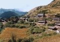
Day 2: Darbang - Lulang
 Darbang bazaar is the last place where supplies are availabale so you'll have to stock
up here. We didn't buy kereosene here on the advice that it would be available in Gurja
Gaun - it wasn't. The path continues from the previous day across the Myagdi Khola on the suspension bridge and
then on the right bank until a steep climb through a pine forest takes you onto a higher
cultivated plateau. Follow the easy path through Dharapani and Takum, both of which are
good places for daal bhaat, until you reach Phalai Gaun. After getting your
trekking permit stamped at the Police check post (probably gone now), descend the path down to the river and
cross. Follow the river on the Dhorpatan path for a couple of kilometres until a right
split in the path takes you up to Lulang. There are no lodges here but owing to my good
fortune at being conversant in Nepali, we were able to blag a stay with the village
chairman or aadakshya. If camping, there is some flat ground at the school
although it is still courteous to introduce yourself to the aadakshya. His will be
the largest and smartest house in the village. Expect to be a source of intense fascination
to the villagers, so be patient with them when they come to stare at you. Darbang bazaar is the last place where supplies are availabale so you'll have to stock
up here. We didn't buy kereosene here on the advice that it would be available in Gurja
Gaun - it wasn't. The path continues from the previous day across the Myagdi Khola on the suspension bridge and
then on the right bank until a steep climb through a pine forest takes you onto a higher
cultivated plateau. Follow the easy path through Dharapani and Takum, both of which are
good places for daal bhaat, until you reach Phalai Gaun. After getting your
trekking permit stamped at the Police check post (probably gone now), descend the path down to the river and
cross. Follow the river on the Dhorpatan path for a couple of kilometres until a right
split in the path takes you up to Lulang. There are no lodges here but owing to my good
fortune at being conversant in Nepali, we were able to blag a stay with the village
chairman or aadakshya. If camping, there is some flat ground at the school
although it is still courteous to introduce yourself to the aadakshya. His will be
the largest and smartest house in the village. Expect to be a source of intense fascination
to the villagers, so be patient with them when they come to stare at you.
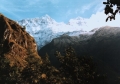
Day 3: Lulang - Darsinge Kharka (via Gurja
Gaun)
 Its a long climb from Lulang to the pass at Deorali (3280m) and
it's a steep descent the other side to Kanabara on the Dhola Khola. If you're lucky (we
weren't) you'll get the first decent panorama of the Dhaulagiri Himal. There are no tea
houses on this route so eat plenty before you set off. Cross the river and ascend to a
plateau. The compact village of Gurja Gaun is about 2km further from the school. Once
again we introduced ourselves to the adakshya who had been a
British Gurkha
and was able to speak some English. He gave us tea and found us the last ½litre of kerosene
in the village. We decided to continue another 5km to Darsinge Kharka, a herder camp at
the base of the long ridge to Budzunga Bara, in order to get an early start on the climb.
To get there from Gurja Gaun, you continue on the main path through the village and onto
potato fields. Cross one river then enter a forest and cross a second. To find the kharka
you have to keep near to the river after crossing the second bridge as there are trails in
all directions. The kharka is a boggy clearing with stock pens which make perfect camping
sites if empty. Its a long climb from Lulang to the pass at Deorali (3280m) and
it's a steep descent the other side to Kanabara on the Dhola Khola. If you're lucky (we
weren't) you'll get the first decent panorama of the Dhaulagiri Himal. There are no tea
houses on this route so eat plenty before you set off. Cross the river and ascend to a
plateau. The compact village of Gurja Gaun is about 2km further from the school. Once
again we introduced ourselves to the adakshya who had been a
British Gurkha
and was able to speak some English. He gave us tea and found us the last ½litre of kerosene
in the village. We decided to continue another 5km to Darsinge Kharka, a herder camp at
the base of the long ridge to Budzunga Bara, in order to get an early start on the climb.
To get there from Gurja Gaun, you continue on the main path through the village and onto
potato fields. Cross one river then enter a forest and cross a second. To find the kharka
you have to keep near to the river after crossing the second bridge as there are trails in
all directions. The kharka is a boggy clearing with stock pens which make perfect camping
sites if empty.
Day 4: Darsinge Kharka - Budzunga Bara camp
 When you rise to cold morning air and the magnificent view up the valley to Gurja
Himal, you get the first feeling of being within close proximity to the mountains. At the
back of the clearing there is a water source and a path that climbs the side of ridge.
Fill up here or from the river as there are no other sources on the ridge itself. The path
takes you up through forest to the main path on the ridge which you join at a small
clearing. There were a lot of trails on the ridge so we left a strip of cloth on a tree to
identify the junction on our return. The path then follows the ridge up above the tree
line and onto rough grass from where the towering peaks of Gurja and Hiunchhuli become
visible on either side. The climb is long and steep but the path is generally good
except for a few narrow, tricky parts. When you rise to cold morning air and the magnificent view up the valley to Gurja
Himal, you get the first feeling of being within close proximity to the mountains. At the
back of the clearing there is a water source and a path that climbs the side of ridge.
Fill up here or from the river as there are no other sources on the ridge itself. The path
takes you up through forest to the main path on the ridge which you join at a small
clearing. There were a lot of trails on the ridge so we left a strip of cloth on a tree to
identify the junction on our return. The path then follows the ridge up above the tree
line and onto rough grass from where the towering peaks of Gurja and Hiunchhuli become
visible on either side. The climb is long and steep but the path is generally good
except for a few narrow, tricky parts.
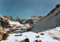
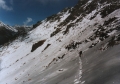
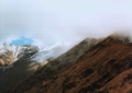 Because
of the unseasonal weather conditions, we encountered fresh snow and dense cloud at about
4000m. Fortunately though, the start of the traverse to the pass, called Budzunga Bara,
was well marked with a large cairn. At this point you have to head west following more
cairns below rocky outcrops to the pass at about 4600m. By now the snow underfoot had
become knee deep and the trekking laborious and uncomfortable. Not expecting snow at this
altitude or time of year, neither of us had brought gaiters and our feet became cold and
wet. Owing to the discomfort and onsetting dusk, we decided not to proceed to base camp, a
further 2-3km down the valley, but to set up camp just below the pass at a small, partly
frozen lake. Because
of the unseasonal weather conditions, we encountered fresh snow and dense cloud at about
4000m. Fortunately though, the start of the traverse to the pass, called Budzunga Bara,
was well marked with a large cairn. At this point you have to head west following more
cairns below rocky outcrops to the pass at about 4600m. By now the snow underfoot had
become knee deep and the trekking laborious and uncomfortable. Not expecting snow at this
altitude or time of year, neither of us had brought gaiters and our feet became cold and
wet. Owing to the discomfort and onsetting dusk, we decided not to proceed to base camp, a
further 2-3km down the valley, but to set up camp just below the pass at a small, partly
frozen lake.
Day 5: Budzunga Bara - Gurja Gaun
 It was a cold night beside the lake, especially when I had to get up to
empty my
bladder at 2am! Still, the stars and mountains were stunning in the crystal-clear
darkness. When dawn broke, we rose to find animal tracks in the snow all around us as
close as 5m to our tent. We were thrilled when we realised they were made by a large
cat, probably a snow leopard. What a privilege to have one the world's rarest and most
elusive big cats sniffing around our tent. I'm glad it wasn’t hungry though! It was a cold night beside the lake, especially when I had to get up to
empty my
bladder at 2am! Still, the stars and mountains were stunning in the crystal-clear
darkness. When dawn broke, we rose to find animal tracks in the snow all around us as
close as 5m to our tent. We were thrilled when we realised they were made by a large
cat, probably a snow leopard. What a privilege to have one the world's rarest and most
elusive big cats sniffing around our tent. I'm glad it wasn’t hungry though!
 After the
excitement of our discovery had subsided, we realised that to press on to base camp and
beyond with no gaiters and dwindling supplies of kerosene and food was probably unwise and
so we reluctantly turned back to Gurja Gaun. This was a pity because the weather seemed to be finally improving. After the aadakshya fed and housed us
for the night and plied us with raksi (a distilled millet liquor) our decision
didn't seem so bad after all. After the
excitement of our discovery had subsided, we realised that to press on to base camp and
beyond with no gaiters and dwindling supplies of kerosene and food was probably unwise and
so we reluctantly turned back to Gurja Gaun. This was a pity because the weather seemed to be finally improving. After the aadakshya fed and housed us
for the night and plied us with raksi (a distilled millet liquor) our decision
didn't seem so bad after all.
Independent
versus Organised Trekking
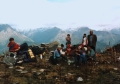
While we were away, a Swiss and French trekking party of 8 had
arrived in Gurja with about 50 porters, guides and cooks and had taken over the school playing
field. I learned from the Nepali guide that they were each paying about $200 a day to the
trekking agency. Virtually none of this money reaches the local communities on the
trekking routes as everything is carried in from Kathmandu. Even on the 'tea house' treks
such as the Annapurna circuit where trekkers' accommodation and food is plentiful, I have
witnessed large trekking parties camping in playgrounds eating brought in food. Many of
these treks are sold to punters under the guise of 'eco-trekking' and indeed they
may well help to reduce pressure on local resources and environment. However,
organised treks are expensive and they contribute very little to village
economies along the trekking routes. It is
actually very easy to trek independently in Nepal or alternatively you can
privately hire a guide
relatively cheaply in Kathmandu or Pokhara. Lodging on trekking routes is cheap and a
great way to meet local people and other trekkers. |
Day 6: Gurja Gaun - Barse Kharka
 This gem of a route passes through the uninhabited south-eastern edge of Dhorpatan
Hunting Reserve. You have to leave Gurja on the path to Darsinge Kharka and then take a
left shortly after the village. This takes you down to the river, over a suspension bridge
and up through a beautiful forest of dead spruce and regenerating maple. The forest must
have be burnt some years ago but the massive spruce trees, although dead, have remained
standing. It's quite a long climb to the pass at 3500m and we were glad to meet a group of
travelling Gurja folk on the pass who offered us breads and tea. This gem of a route passes through the uninhabited south-eastern edge of Dhorpatan
Hunting Reserve. You have to leave Gurja on the path to Darsinge Kharka and then take a
left shortly after the village. This takes you down to the river, over a suspension bridge
and up through a beautiful forest of dead spruce and regenerating maple. The forest must
have be burnt some years ago but the massive spruce trees, although dead, have remained
standing. It's quite a long climb to the pass at 3500m and we were glad to meet a group of
travelling Gurja folk on the pass who offered us breads and tea.
 By the time we reached the pass the
cloud had once again enclosed the mountains, denying us of a spectacular panorama. In
complete contrast to the north, the south side of the pass is a gently sloping, virtually
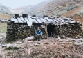
tree-less valley used for grazing mules during the monsoon. Scattered around the
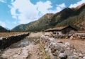
valley were many stone huts used by the herders and their livestock for shelter during the
grazing season, but now abandoned for the winter. Not wanting to miss the view, we decided
to spend the night in a hut just below the pass near the water source and rise at the
crack to watch the dawn illumination of the snowy peaks. By the time we reached the pass the
cloud had once again enclosed the mountains, denying us of a spectacular panorama. In
complete contrast to the north, the south side of the pass is a gently sloping, virtually
tree-less valley used for grazing mules during the monsoon. Scattered around the
valley were many stone huts used by the herders and their livestock for shelter during the
grazing season, but now abandoned for the winter. Not wanting to miss the view, we decided
to spend the night in a hut just below the pass near the water source and rise at the
crack to watch the dawn illumination of the snowy peaks.
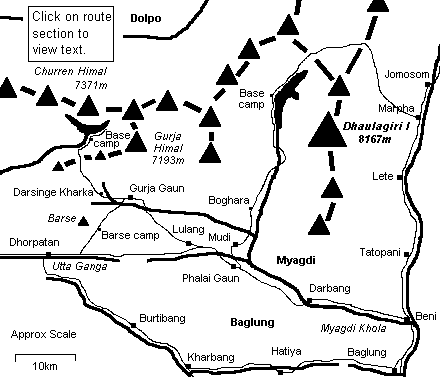
Day 7: Barse Kharka - Dhorpatan
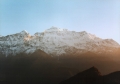 It was an act of masochism to get myself out of my 4 season bag and slog back up to the
pass in the frosty darkness. It was worth it though - the view that greeted us was
awesome. A luminescent mountain panorama stretched from Dogari Himal in the west to
Dhaulagiri I in the east. As sunlight struck the peaks they were set ablaze in brilliant
whiteness. The whole experience was truly magical. It was an act of masochism to get myself out of my 4 season bag and slog back up to the
pass in the frosty darkness. It was worth it though - the view that greeted us was
awesome. A luminescent mountain panorama stretched from Dogari Himal in the west to
Dhaulagiri I in the east. As sunlight struck the peaks they were set ablaze in brilliant
whiteness. The whole experience was truly magical.
 After returning to the hut for a porridge breakfast, we set off down the valley towards
Dhorpatan. After a short distance the pasture changes to forest and the path switches
banks over an icy tree-trunk bridge. A little futher down and it reverts back again over
another icy log which lost me my balance and sent me face first into the river! After 3
hours or so from the huts you reach the Utta Ganga valley; a 3000m high broad flood plain
that meanders its way down to Dhorpatan. We stopped at the first house to chance our luck
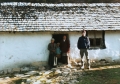
for some bhaat and got a feast of meat, rice and potatoes. From here, Dhorpatan
was a long but easy walk through pine and spruce forest. On arrival in Dhorpatan, we were
spotted by the park ranger who, in spite of it being a Saturday, opened up the office so we
could sign the register and pay our permit fee as we hadn't bought one in Kathmandu as we
were supposed to. He directed us to a cracking little guest house down by the airstrip run
by a Tibetan family. After returning to the hut for a porridge breakfast, we set off down the valley towards
Dhorpatan. After a short distance the pasture changes to forest and the path switches
banks over an icy tree-trunk bridge. A little futher down and it reverts back again over
another icy log which lost me my balance and sent me face first into the river! After 3
hours or so from the huts you reach the Utta Ganga valley; a 3000m high broad flood plain
that meanders its way down to Dhorpatan. We stopped at the first house to chance our luck
for some bhaat and got a feast of meat, rice and potatoes. From here, Dhorpatan
was a long but easy walk through pine and spruce forest. On arrival in Dhorpatan, we were
spotted by the park ranger who, in spite of it being a Saturday, opened up the office so we
could sign the register and pay our permit fee as we hadn't bought one in Kathmandu as we
were supposed to. He directed us to a cracking little guest house down by the airstrip run
by a Tibetan family.
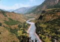
Dhorpatan at a
glance
Dhorpatan is a village of 2 communities: the
indigenous Nepalese and the Tibetan refugees who fled here after the Chinese invasion. The
Tibetan areas are clearly recognisable from the Buddhist prayer flags that flutter above
every house, sending their mantras up to heaven. The area is important for potato and
apple growing, mule breeding and is a distribution centre for salt and
other goods that brought in from Dolpo and Tibet. The surrounding reserve is a national park covering 1325 sq km which was
managed for conservation and the hunting of blue sheep (bharal) and
other game by the royal family and paying foreign parties. Now, of course,
with the king deposed, official hunting has ceased and blue sheep, along
with the musk deer, wolf, red panda and leopard are strictly protected. |
Days 8-11: Dhorpatan - Baglung (via
Burtibang, Kharbang and Hatiya)
 Day 8: Going to Burtibang from Dhorpatan
necessitates crossing the Utta Ganga river.
Unfortunately, the nearest bridge is way upstream and if you're as lazy as we were, wading
bare-legged through the cold water close to the hotel will be the chosen crossing point.
You need to head due south from Dhorpatan to the river and find a shallow place to cross.
The river here was braided into 2 channels which meant twice the agony. Make sure, unlike
me, that you bring everything with you before making the crossing, otherwise 2 further
trips through the river will be necessary! There's a short climb to a pass and then a long
descent (6 hours) down the Bhuli Khola to Burtibang. A lodge half way at Bobang
cooked us bhaat on request. Burtibang is Baglung
district's second largest town and there's a choice of Hotels here. We stayed at the
'Sherchan' at the far end of the bazaar which was quite comfortable except for the toilet
which is probably the smelliest I have ever had the misfortune to squat over. Day 8: Going to Burtibang from Dhorpatan
necessitates crossing the Utta Ganga river.
Unfortunately, the nearest bridge is way upstream and if you're as lazy as we were, wading
bare-legged through the cold water close to the hotel will be the chosen crossing point.
You need to head due south from Dhorpatan to the river and find a shallow place to cross.
The river here was braided into 2 channels which meant twice the agony. Make sure, unlike
me, that you bring everything with you before making the crossing, otherwise 2 further
trips through the river will be necessary! There's a short climb to a pass and then a long
descent (6 hours) down the Bhuli Khola to Burtibang. A lodge half way at Bobang
cooked us bhaat on request. Burtibang is Baglung
district's second largest town and there's a choice of Hotels here. We stayed at the
'Sherchan' at the far end of the bazaar which was quite comfortable except for the toilet
which is probably the smelliest I have ever had the misfortune to squat over.
Day 9: The path (probably now a jeep track) to Kharbang (6 hours) continues down the river although there is some ascending
to be done. The hotel is located close to the junction with the Baglung path, as
was a
satellite phone service.
Day 10: The Baglung trail heads east from the bazaar and climbs up above the river.
Hatiya takes about 6 hours from Kharbang and the only village where bhaat is
available is conveniently situated half way along. Hatiya is the district's 3rd largest
town and there's a few Hotels to choose from here too. The first one on the right-hand
side as you reach the town (I forget the name) was an old favorite of mine during my
volunteering days. Alternatively, if going to Tamghas and Tansen, cross the big suspension
bridge at Kharbang and continue south down the Bari Khola. Tamghas is about 1½ days from
Kharbang from where buses to Tansen run.
Day 11: The final day to Baglung is a bit of a long one which continues
on the trail
throught the bazaar and eastward and upward to a pass at Roini (2000m) where you can get
snacks and daal bhaat. From here it's a long, hot descent on a mule worn trail to
Baglung bazaar. The abundance of tea houses and restaurants however, will offer some
respite to the trail weary.
|