 |
||||||||||||||||||||||||||||||||||||||||||||||||||||||||||||||||||||||||||||||||||||||||||||||||||||||||||||||||||||||||||||||||||||||||||||||||||||||||||||||||||||||||||||||||||||||||||||||||||||||||||||||||||||||||||||||||||||||||||
|
|
||||||||||||||||||||||||||||||||||||||||||||||||||||||||||||||||||||||||||||||||||||||||||||||||||||||||||||||||||||||||||||||||||||||||||||||||||||||||||||||||||||||||||||||||||||||||||||||||||||||||||||||||||||||||||||||||||||||||||
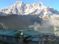
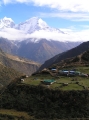
Day 4: Khumjung - Tengboche
|
||||||||||||||||||||||||||||||||||||||||||||||||||||||||||||||||||||||||||||||||||||||||||||||||||||||||||||||||||||||||||||||||||||||||||||||||||||||||||||||||||||||||||||||||||||||||||||||||||||||||||||||||||||||||||||||||||||||||||
Walking time |
3.5 hours |
Altitude gained |
70m |
Sleeping altitude |
3860m |
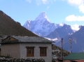
 At
last
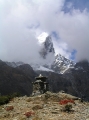
we woke to clearer skies and views of Ama Dablam (6856m), Thamserku (6608m) and Kang Tega (6685m). Encouraged by the improved
weather, we set off for Tengboche which started on a trail at the bottom of the village, near the bakery. Once out of the
village, the path drops steeply through forest to Phunki Tenga where it crosses the Dudh Koshi. From here it climbs steeply to
Tengboche, 600 vertical metres up at the top of a ridge. To put my fitness to the test, I picked up the pace and did the
ascent in just under an hour. A more typical time for the climb is 1½ hours while the guide book has it
taking up to 2½ hours.
At
last
we woke to clearer skies and views of Ama Dablam (6856m), Thamserku (6608m) and Kang Tega (6685m). Encouraged by the improved
weather, we set off for Tengboche which started on a trail at the bottom of the village, near the bakery. Once out of the
village, the path drops steeply through forest to Phunki Tenga where it crosses the Dudh Koshi. From here it climbs steeply to
Tengboche, 600 vertical metres up at the top of a ridge. To put my fitness to the test, I picked up the pace and did the
ascent in just under an hour. A more typical time for the climb is 1½ hours while the guide book has it
taking up to 2½ hours.
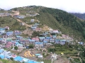
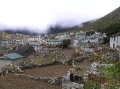
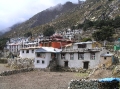
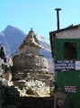
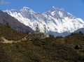
 Tengboche is small village
comprised mostly of lodges with a large gompa at its centre. We selected the Himalayan View which had some of the better rooms with the potential for good
views, although we were never to see them as the cloud had once again closed in. After lunch and a much needed shower, we made the obligatory
visit to the gompa. The main prayer hall was interesting with lots of painted Mandalas on the walls and a large golden Buddha at the far end of the
room. There weren't any religious ceremonies to watch though - the monks were down the village playing volleyball instead. Despite having only
been established in 1916 the gompa had been rebuilt twice, the first time following an earthquake in 1934 and more recently, after a fire in 1989.
Tengboche is small village
comprised mostly of lodges with a large gompa at its centre. We selected the Himalayan View which had some of the better rooms with the potential for good
views, although we were never to see them as the cloud had once again closed in. After lunch and a much needed shower, we made the obligatory
visit to the gompa. The main prayer hall was interesting with lots of painted Mandalas on the walls and a large golden Buddha at the far end of the
room. There weren't any religious ceremonies to watch though - the monks were down the village playing volleyball instead. Despite having only
been established in 1916 the gompa had been rebuilt twice, the first time following an earthquake in 1934 and more recently, after a fire in 1989.
Day 5: Tengboche - Pangboche
Walking time |
1.5 hours |
Altitude gained |
140m |
Sleeping altitude |
4000m |
 The night in Tengboche put us back on
track with our acclimatisation plan (if you forget about the night skipped between Lukla and Namche that is) and those of us who had already
suffered with AMS had now fully recovered. The walk to Pangboche was another short one and deliberately so as it broke up the 500m
altitude gain
from Tengboche to Dingboche and gave us an acclimatisation catch up opportunity.
The night in Tengboche put us back on
track with our acclimatisation plan (if you forget about the night skipped between Lukla and Namche that is) and those of us who had already
suffered with AMS had now fully recovered. The walk to Pangboche was another short one and deliberately so as it broke up the 500m
altitude gain
from Tengboche to Dingboche and gave us an acclimatisation catch up opportunity.
 We left Tengboche in dense mist
and descended through rhododendron and birch forest to Deboche (30 mins) where we crossed the river on a high cage-like metal bridge. From here it
was a gradual ascent for about an hour to reach Pangboche. Pangboche is really 2 separate villages about 10 minutes apart and although it is
possible to reach the upper village without passing through Lower Pangboche, we missed the path and had to detour via the lower village to get
back up the hill. We had decided to stay in Upper Pangboche to benefit from the slightly higher altitude and because of its attractive setting
around the old gompa. We stayed at the Trekker's Holiday Inn which was owned by a climbing sherpa with several Everest summits to his name. The
rooms were typical plywood twins costing Rs.150 a night. In the afternoon, the rain started and continued on into the night so to alleviate the
depression setting in, we drank chang (rice beer) and played a homemade pub quiz until the sherpani hinted for us to go to bed at 8:30.
We left Tengboche in dense mist
and descended through rhododendron and birch forest to Deboche (30 mins) where we crossed the river on a high cage-like metal bridge. From here it
was a gradual ascent for about an hour to reach Pangboche. Pangboche is really 2 separate villages about 10 minutes apart and although it is
possible to reach the upper village without passing through Lower Pangboche, we missed the path and had to detour via the lower village to get
back up the hill. We had decided to stay in Upper Pangboche to benefit from the slightly higher altitude and because of its attractive setting
around the old gompa. We stayed at the Trekker's Holiday Inn which was owned by a climbing sherpa with several Everest summits to his name. The
rooms were typical plywood twins costing Rs.150 a night. In the afternoon, the rain started and continued on into the night so to alleviate the
depression setting in, we drank chang (rice beer) and played a homemade pub quiz until the sherpani hinted for us to go to bed at 8:30.
|
|
|||||||||||||||||||||||||||||||||||||||||||||||||||||||||||||||||||||||||||||||||||||||||||
Day 6: Pangboche - Dingboche
Walking time |
2.5 hours |
Altitude gained |
350m |
Sleeping altitude |
4350m |
 It was cloudy when we left Pangboche at
about 9:30 but we did at least get partial views of Thamserku and Ama Dablam. We took the trail heading for Lower Pangboche but then forked
left just after entering the juniper forest to traverse above it. The trail then joined the main Tengboche-Dingboche path several hundred
metres after the lower village ended. After a gradual climb for an hour on a trail that went high above the Imja Khola, we passed through Shomare from
where we first glimpsed Lhotse and, if there'd been less cloud, perhaps Everest too. After a further hour, the trail forked right down to the river
and crosses onto a trail that bore north-east around the right side of a small hill. Its easy to miss this path and continue on the left side of
the ridge which would take you to Pheriche instead. From the bridge, its just over half and hour to Dingboche. We picked one of the new lodges which was a mistake as
the quality and quantity of the food was below average and the drinking water was contaminated with kerosene. I recommend sticking to the
traditional family-run lodges where the owners and staff are more likely to care about your experience in addition to your money.
It was cloudy when we left Pangboche at
about 9:30 but we did at least get partial views of Thamserku and Ama Dablam. We took the trail heading for Lower Pangboche but then forked
left just after entering the juniper forest to traverse above it. The trail then joined the main Tengboche-Dingboche path several hundred
metres after the lower village ended. After a gradual climb for an hour on a trail that went high above the Imja Khola, we passed through Shomare from
where we first glimpsed Lhotse and, if there'd been less cloud, perhaps Everest too. After a further hour, the trail forked right down to the river
and crosses onto a trail that bore north-east around the right side of a small hill. Its easy to miss this path and continue on the left side of
the ridge which would take you to Pheriche instead. From the bridge, its just over half and hour to Dingboche. We picked one of the new lodges which was a mistake as
the quality and quantity of the food was below average and the drinking water was contaminated with kerosene. I recommend sticking to the
traditional family-run lodges where the owners and staff are more likely to care about your experience in addition to your money.
 In the afternoon, the
guys trekked over to Pheriche to listen to the daily 3pm altitude lecture given by doctors at the
Himalayan Rescue Association (HRA) hospital. I
fired on up to Thuklha to book our rooms for the following night in the one and only lodge there. After cup of tea with the lodge owner, I motored
back down the hill to Pheriche to catch up with the guys at the hospital. Without my rucksack weighing me down, it only took me an hour to get to
Thuklha and ¾ hour to get back to Pheriche. I got back in time to have my blood oxygen levels measured using a small
device that fitted over the finger. The reading was 86% which was high for that altitude and indicative of good acclimatisation (blood oxygen is normally 99%
at sea level). This service cost a Rs.100 donation. The hike back to Dingboche was a short 40 minute walk over the ridge that
would normally offer great views of Ama Dablam, Nuptse and Lhotse, but for us, was once again shrouded in cloud.
In the afternoon, the
guys trekked over to Pheriche to listen to the daily 3pm altitude lecture given by doctors at the
Himalayan Rescue Association (HRA) hospital. I
fired on up to Thuklha to book our rooms for the following night in the one and only lodge there. After cup of tea with the lodge owner, I motored
back down the hill to Pheriche to catch up with the guys at the hospital. Without my rucksack weighing me down, it only took me an hour to get to
Thuklha and ¾ hour to get back to Pheriche. I got back in time to have my blood oxygen levels measured using a small
device that fitted over the finger. The reading was 86% which was high for that altitude and indicative of good acclimatisation (blood oxygen is normally 99%
at sea level). This service cost a Rs.100 donation. The hike back to Dingboche was a short 40 minute walk over the ridge that
would normally offer great views of Ama Dablam, Nuptse and Lhotse, but for us, was once again shrouded in cloud.
|
|
Day 7: Dingboche - Thuklha
Walking time |
2 hours |
Altitude gained |
250m |
Sleeping altitude |
4600m |
 It was another misty
dawn but did start to clear by 7:30 giving partial views of Ama Dablam, Thamserku and Kang Tega. We left the lodge without breakfast and hiked a
few metres up the hill to the Alpine Resort where we ordered pancakes, muesli, toast and eggs, and wondered why we hadn't stayed here instead. We
hit the trail at 11am by which time Ama Dablam was in full view, towering above us to the east. The trail climbed above the Alpine Resort to a stupa on the ridge where it joined the Chukhung-Lobuche path. From here it was a slowly ascending path on broad lateral moraine, about 100m above
the Lobuche Khola river. Pheriche was clearly visible on the valley floor below. After about 1½ hours the path descended to a
bridge over the river and then it was a further 5 minutes climb to the Yak Lodge at Thuklha. The rooms had been reserved but on this occasion we
needn't have worried as there were still plenty left. After lunch, we hiked up the steep moraine, a strenuous climb that took ½ hour without the
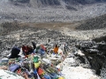
packs on, to view memorials dedicated to some of the Everest dead. There was a depressingly large number of chortens and memorials, which I guess
is hardly surprising considering the number of fatalities there has been on the mountain. The most notable was for Babu Chiri Sherpa who summited 10 times before dying
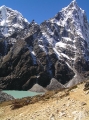
on his 11th attempt. For brief period we were rewarded with views of Arakam Tse (6423m), Cholatse (6335m) and Taboche (6367m) before the cloud
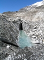
once again descended. We returned to Thuklha on the Dzonglha path in the hope of seeing the turquoise Chola Tsho lake, but the mist was so thick
it was impossible to see more than 50m in front of us. The junction where the Dzonglha path meets the trail back to Thuklha is easy to miss,
especially in such poor visibility. We were lucky to meet some porters who pointed it out to us.
It was another misty
dawn but did start to clear by 7:30 giving partial views of Ama Dablam, Thamserku and Kang Tega. We left the lodge without breakfast and hiked a
few metres up the hill to the Alpine Resort where we ordered pancakes, muesli, toast and eggs, and wondered why we hadn't stayed here instead. We
hit the trail at 11am by which time Ama Dablam was in full view, towering above us to the east. The trail climbed above the Alpine Resort to a stupa on the ridge where it joined the Chukhung-Lobuche path. From here it was a slowly ascending path on broad lateral moraine, about 100m above
the Lobuche Khola river. Pheriche was clearly visible on the valley floor below. After about 1½ hours the path descended to a
bridge over the river and then it was a further 5 minutes climb to the Yak Lodge at Thuklha. The rooms had been reserved but on this occasion we
needn't have worried as there were still plenty left. After lunch, we hiked up the steep moraine, a strenuous climb that took ½ hour without the
packs on, to view memorials dedicated to some of the Everest dead. There was a depressingly large number of chortens and memorials, which I guess
is hardly surprising considering the number of fatalities there has been on the mountain. The most notable was for Babu Chiri Sherpa who summited 10 times before dying
on his 11th attempt. For brief period we were rewarded with views of Arakam Tse (6423m), Cholatse (6335m) and Taboche (6367m) before the cloud
once again descended. We returned to Thuklha on the Dzonglha path in the hope of seeing the turquoise Chola Tsho lake, but the mist was so thick
it was impossible to see more than 50m in front of us. The junction where the Dzonglha path meets the trail back to Thuklha is easy to miss,
especially in such poor visibility. We were lucky to meet some porters who pointed it out to us.
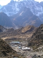
Day 8: Thuklha - Lobuche
Walking time |
2 hours |
Altitude gained |
340m |
Sleeping altitude |
4940m |
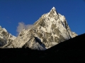 The monsoon had
finally retreated today and for the first time on the trek, we woke up to clear blue skies and a spectacular mountain panorama.
To the west, the towering peaks of Arakam Tse, Cholatse and Taboche glistened in the early morning light. To the north, Nuptse was visible and
to the south, Ama Dablam, Thamserku and Kang Tega. At last we realised we were in the Himalaya. The change in weather lifted the mood of the entire
group and everyone was up early and on the trail by 9am, the earliest start so far. The steep climb up the moraine didn't seem so difficult today,
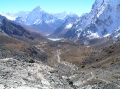
even with the pack on; a good sign that we were acclimatising well. From the top of the climb, the path continued for 1½ hours
below the Khumbu Glacier's western lateral moraine to Lobuche, a small, uninspiring cluster of 6 lodges
We randomly chose the Sherpa Lodge where we lunched, washed, shaved and did laundry in the warn sunshine.
The monsoon had
finally retreated today and for the first time on the trek, we woke up to clear blue skies and a spectacular mountain panorama.
To the west, the towering peaks of Arakam Tse, Cholatse and Taboche glistened in the early morning light. To the north, Nuptse was visible and
to the south, Ama Dablam, Thamserku and Kang Tega. At last we realised we were in the Himalaya. The change in weather lifted the mood of the entire
group and everyone was up early and on the trail by 9am, the earliest start so far. The steep climb up the moraine didn't seem so difficult today,
even with the pack on; a good sign that we were acclimatising well. From the top of the climb, the path continued for 1½ hours
below the Khumbu Glacier's western lateral moraine to Lobuche, a small, uninspiring cluster of 6 lodges
We randomly chose the Sherpa Lodge where we lunched, washed, shaved and did laundry in the warn sunshine.
 In the afternoon, some of us
hiked up to Gorak Shep to advance book our lodge for the next night. The walk was a lot longer and tougher than we expected and a couple of the
guys turned back early. The path climbed up to the Lobuche Pass at 5110m then crossed the Changri Nup and Changri Shar glaciers to Gorak Shep. The
terrain was rough but the exertion was more than rewarded by unbroken views of Nuptse, Pumori and eventually the summit cone of Everest. We
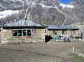
selected the first lodge of the 3, the Himalayan, where we reserved rooms for the following night. The lodge was large, modern and well maintained
- impressive for such a remote and inhospitable place. Prices were high here though: Rs.300 for a room, Rs.250 for daal bhaat, Rs.150 for a
chocolate bar and Rs.300 for a shower (although you'd have to be a masochist to have one of these up here). The return trip took an hour, and by
the time we got back the sun had dropped behind the western mountains, casting a cold shadow over the valley. The time for thermals had arrived.
In the afternoon, some of us
hiked up to Gorak Shep to advance book our lodge for the next night. The walk was a lot longer and tougher than we expected and a couple of the
guys turned back early. The path climbed up to the Lobuche Pass at 5110m then crossed the Changri Nup and Changri Shar glaciers to Gorak Shep. The
terrain was rough but the exertion was more than rewarded by unbroken views of Nuptse, Pumori and eventually the summit cone of Everest. We
selected the first lodge of the 3, the Himalayan, where we reserved rooms for the following night. The lodge was large, modern and well maintained
- impressive for such a remote and inhospitable place. Prices were high here though: Rs.300 for a room, Rs.250 for daal bhaat, Rs.150 for a
chocolate bar and Rs.300 for a shower (although you'd have to be a masochist to have one of these up here). The return trip took an hour, and by
the time we got back the sun had dropped behind the western mountains, casting a cold shadow over the valley. The time for thermals had arrived.
|
|
Day 9: Lobuche - Kala Pattar - Gorak Shep
Walking time |
4 hours |
Altitude gained |
230m |
Sleeping altitude |
5170m |
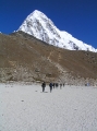 Today was the
big one, the reason we'd come to the Khumbu - the ascent of Kala Pattar to see Everest. We emptied out all the unessential items from our packs
and left them in the lodge store room to collect on the way back down. We stocked up on biscuits and chocolate and hit the trail at 7am. It was a
beautiful clear day again with Pumori, Nuptse, Lobuche, and Changri looking spectacular in the morning sunlight. The hike was a little easier today and took me only 1½ hours
to reach the lodge at Gorak Shep. After ditching the packs and a quick cup of tea, we set off to climb Kala Pattar.
Today was the
big one, the reason we'd come to the Khumbu - the ascent of Kala Pattar to see Everest. We emptied out all the unessential items from our packs
and left them in the lodge store room to collect on the way back down. We stocked up on biscuits and chocolate and hit the trail at 7am. It was a
beautiful clear day again with Pumori, Nuptse, Lobuche, and Changri looking spectacular in the morning sunlight. The hike was a little easier today and took me only 1½ hours
to reach the lodge at Gorak Shep. After ditching the packs and a quick cup of tea, we set off to climb Kala Pattar.
 Kala Pattar is not really a
peak, but the lower part of the south Pumori ridge. The highest accessible point before the ridge becomes too narrow and dangerous (not visible from Gorak Shep) is
at an altitude of about 5600m. There are 2 ways up to this "summit", the least strenuous of which is on the right-hand path that skirts around the lower
summit, or there's the steeper path up and over the lower summit. Naturally, we took the least strenuous option. It was an exhausting slog in such thin air (50% of sea level air pressure at this altitude) but I made the top in
65 minutes. A more typical ascent is 90 minutes.
Kala Pattar is not really a
peak, but the lower part of the south Pumori ridge. The highest accessible point before the ridge becomes too narrow and dangerous (not visible from Gorak Shep) is
at an altitude of about 5600m. There are 2 ways up to this "summit", the least strenuous of which is on the right-hand path that skirts around the lower
summit, or there's the steeper path up and over the lower summit. Naturally, we took the least strenuous option. It was an exhausting slog in such thin air (50% of sea level air pressure at this altitude) but I made the top in
65 minutes. A more typical ascent is 90 minutes.
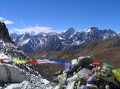
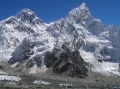 The panorama of mountains and glaciers was awe inspiring and emotionally overwhelming. I sat by the summit cairn for over half an
hour just taking it all in. Everest was visible as far down as the South Col, and the formidable Khumbu Icefall could be seen flowing into the
rock-covered Khumbu Glacier. Even at this height I felt dwarfed by the colossal peaks around me. Pumori towered above me to the north while in the
east, Nuptse dominated the skyline. To the south was Ama Dablam and west Lobuche and Changri. Beyond these were more mountains stretching as far as the eye could see. It was truly,
and quite literally, breath taking.
The panorama of mountains and glaciers was awe inspiring and emotionally overwhelming. I sat by the summit cairn for over half an
hour just taking it all in. Everest was visible as far down as the South Col, and the formidable Khumbu Icefall could be seen flowing into the
rock-covered Khumbu Glacier. Even at this height I felt dwarfed by the colossal peaks around me. Pumori towered above me to the north while in the
east, Nuptse dominated the skyline. To the south was Ama Dablam and west Lobuche and Changri. Beyond these were more mountains stretching as far as the eye could see. It was truly,
and quite literally, breath taking.
 After having spent about 45
minutes on the top I felt cold and decided to return directly to Gorak Shep by the route I'd come. A couple of the guys took the
alternative path down over the lower summit which made an interest variation to the descent. Back at the lodge I called
my wife on the satellite phone. The reception was amazing and it was completely surreal to be talking to her from such a high and remote place. At
a reasonable Rs.250 ($3.5) per minute, it was the best money I'd ever spent. After lunch, a ham and
cheese toastie made from ex-expedition spam and processed cheese, a couple of the guys decided to descend to Lobuche. One was
suffering with mild AMS and didn't want to risk spending the night here. We planned to meet up with them the following day.
After having spent about 45
minutes on the top I felt cold and decided to return directly to Gorak Shep by the route I'd come. A couple of the guys took the
alternative path down over the lower summit which made an interest variation to the descent. Back at the lodge I called
my wife on the satellite phone. The reception was amazing and it was completely surreal to be talking to her from such a high and remote place. At
a reasonable Rs.250 ($3.5) per minute, it was the best money I'd ever spent. After lunch, a ham and
cheese toastie made from ex-expedition spam and processed cheese, a couple of the guys decided to descend to Lobuche. One was
suffering with mild AMS and didn't want to risk spending the night here. We planned to meet up with them the following day.
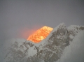 At sunset, the valley was
plunged into shadow and the only sunlight visible was on the summit cone of Everest which was lit up in brilliant orange like it was on fire. The temperature dropped quickly
so we retreated into the dining room heated by the yak dung fired stove. On the menu were a range of snacks, meals and
sweets left over from previous Everest expeditions. As a change from the usual daal bhaat and fried noodles, we ordered a chicken dopiaza
with rice. Boil-in-the-bag curry had never tasted good.
At sunset, the valley was
plunged into shadow and the only sunlight visible was on the summit cone of Everest which was lit up in brilliant orange like it was on fire. The temperature dropped quickly
so we retreated into the dining room heated by the yak dung fired stove. On the menu were a range of snacks, meals and
sweets left over from previous Everest expeditions. As a change from the usual daal bhaat and fried noodles, we ordered a chicken dopiaza
with rice. Boil-in-the-bag curry had never tasted good.
Day 10: Gorak Shep - Everest Base Camp - Lobuche
Walking time |
5 hours |
Altitude lost |
230m |
Sleeping altitude |
4940m |
 Today was an even
tougher day than Kala Pattar and we were glad for the day in hand that allowed us to stop at Lobuche rather than go on to Dzonglha as we had
originally planned. We started off from Gorak Shep at 8:30 and didn't reach base camp until 11:00, 2½ tiring hours later.
We did take a slight detour to view the memorials to some of the Everest dead, including members of the ill-fated 1996 expeditions with Adventure
Consultants and Mountain Madness. The path followed the crest of the western lateral moraine for the first 75 minutes before dropping down onto the
glacier where it continued for a further 75 minutes. On the glacier, the path was rough and meandered around the crevasses but wasn't at all dangerous.
Today was an even
tougher day than Kala Pattar and we were glad for the day in hand that allowed us to stop at Lobuche rather than go on to Dzonglha as we had
originally planned. We started off from Gorak Shep at 8:30 and didn't reach base camp until 11:00, 2½ tiring hours later.
We did take a slight detour to view the memorials to some of the Everest dead, including members of the ill-fated 1996 expeditions with Adventure
Consultants and Mountain Madness. The path followed the crest of the western lateral moraine for the first 75 minutes before dropping down onto the
glacier where it continued for a further 75 minutes. On the glacier, the path was rough and meandered around the crevasses but wasn't at all dangerous.
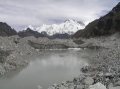
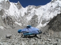 There
were no climbing expeditions on the Nepalese side of the mountain this season so base camp was deserted. The only signs of previous life here were
the discarded rubbish and the 2 crashed helicopters. The older and more mangled wreckage was from a crash in 2003 in which 2 people were killed. The
other helicopter (pictured) was from a non-fatal crash in April 2005. Neither were essential nor emergency flights. Its a miracle helicopters can land here at
all looking at the terrain. The following
article, reporting the
2005 crash, highlights the unnecessary risks with making such non-emergency flights.
There
were no climbing expeditions on the Nepalese side of the mountain this season so base camp was deserted. The only signs of previous life here were
the discarded rubbish and the 2 crashed helicopters. The older and more mangled wreckage was from a crash in 2003 in which 2 people were killed. The
other helicopter (pictured) was from a non-fatal crash in April 2005. Neither were essential nor emergency flights. Its a miracle helicopters can land here at
all looking at the terrain. The following
article, reporting the
2005 crash, highlights the unnecessary risks with making such non-emergency flights.
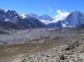
 Everest base
camp is described by some as an anti-climax and not worth the effort. I would have to strongly disagree. While Everest itself isn't visible from
here, the scenery is stunning and to see the fearsome Khumbu Icefall so close up is reason enough to make the trip. Base camp is located at the
head of the Khumbu Glacier valley and standing here is like being in an amphitheatre surrounded by a colossal wall of snowy mountains and ridges.
Going clockwise from the Lho La (NW Col), the West Ridge climbs from the col around the Western Cwm and out of sight to the summit of Everest.
Emerging from the cwm is the Khumbu Icefall, a brilliant white icy mass of seracs and crevasses that has claimed so many of the lives lost on
Everest. Next round from the cwm is the majestic Nuptse, then across the Khumbu Glacier is Pumori, Lingtren and lastly, Khumbutse. Despite being
so high up here at base camp, only slightly under 5400m in fact, I felt small and humbled standing beneath these mountains. Nuptse towers above
for another 2km and Everest
for another 3km. Anyone who recommends missing this out either never came here or came up with their eyes shut.
Everest base
camp is described by some as an anti-climax and not worth the effort. I would have to strongly disagree. While Everest itself isn't visible from
here, the scenery is stunning and to see the fearsome Khumbu Icefall so close up is reason enough to make the trip. Base camp is located at the
head of the Khumbu Glacier valley and standing here is like being in an amphitheatre surrounded by a colossal wall of snowy mountains and ridges.
Going clockwise from the Lho La (NW Col), the West Ridge climbs from the col around the Western Cwm and out of sight to the summit of Everest.
Emerging from the cwm is the Khumbu Icefall, a brilliant white icy mass of seracs and crevasses that has claimed so many of the lives lost on
Everest. Next round from the cwm is the majestic Nuptse, then across the Khumbu Glacier is Pumori, Lingtren and lastly, Khumbutse. Despite being
so high up here at base camp, only slightly under 5400m in fact, I felt small and humbled standing beneath these mountains. Nuptse towers above
for another 2km and Everest
for another 3km. Anyone who recommends missing this out either never came here or came up with their eyes shut.
 After half an hour at
base camp we made a hasty retreat back to Gorak Shep, stopping only briefly on the way to watch an avalanche crash down the lower west face of
Nuptse. The return trek took 1¼ hours and we arrived back at the Himalayan at 12:45 in
time for lunch and a snooze in the sun room. It was another 1¼ hours back to Lobuche but by now the sun was setting and the light and warmth were
fading fast. There was no way we'd have made it to Dzonglha as originally planned. On arrival in Lobuche we returned to the Sherpa Lodge to
be given a note from the other 2 saying that they had headed back to Namche. We were naturally disappointed but
resolved to continue over the Cho La to Gokyo as planned.
After half an hour at
base camp we made a hasty retreat back to Gorak Shep, stopping only briefly on the way to watch an avalanche crash down the lower west face of
Nuptse. The return trek took 1¼ hours and we arrived back at the Himalayan at 12:45 in
time for lunch and a snooze in the sun room. It was another 1¼ hours back to Lobuche but by now the sun was setting and the light and warmth were
fading fast. There was no way we'd have made it to Dzonglha as originally planned. On arrival in Lobuche we returned to the Sherpa Lodge to
be given a note from the other 2 saying that they had headed back to Namche. We were naturally disappointed but
resolved to continue over the Cho La to Gokyo as planned.
Day 11: Lobuche - Dzonglha
Walking time |
3 hours |
Altitude lost |
90m |
Sleeping altitude |
4850m |
 I
came down with dysentery in the night. It had to happen eventually. The symptoms at first suggested food poisoning although I was a bit suspicious
why none of the others had come down with it. I was to find out a couple of days later as the illness matured, that it was in fact Giardia. This
initial wrong diagnosis caused me to prolong the disease by taking the wrong treatment (Ciprofloxacin instead of Tinadazole). Despite the nausea, I
managed to force down a couple of boiled eggs for breakfast and we were on the trail by 8:30. However, I struggled from the start and was going to
turn back when the guys took my rucksack from me and took it in turns to carry it between them. My pace was slow and I stopped frequently to vomit or
collapse, but after 4 long agonising hours I was virtually dragged into Dzonghla.
I
came down with dysentery in the night. It had to happen eventually. The symptoms at first suggested food poisoning although I was a bit suspicious
why none of the others had come down with it. I was to find out a couple of days later as the illness matured, that it was in fact Giardia. This
initial wrong diagnosis caused me to prolong the disease by taking the wrong treatment (Ciprofloxacin instead of Tinadazole). Despite the nausea, I
managed to force down a couple of boiled eggs for breakfast and we were on the trail by 8:30. However, I struggled from the start and was going to
turn back when the guys took my rucksack from me and took it in turns to carry it between them. My pace was slow and I stopped frequently to vomit or
collapse, but after 4 long agonising hours I was virtually dragged into Dzonghla.
 Our booking at the
Himalayan Lodge had been made for us, but for the following night, and all but 1 of the rooms had already been taken. The only other lodge in Dzonglha was also full. The guys kindly gave me the free single and reluctantly took dormitory beds. I went straight to bed and apart from
frequent trips to the toilet, stayed there until next morning. The guys, by all accounts, had a boring afternoon hanging out at the lodge and then a
sleepless night in the dorm. There were just 2 long bunks, each sleeping about a dozen people in very close proximity to each other. Eric was so
claustrophobic he chose to sleep on the floor of my tiny single room instead. It was a bad night for everyone.
Our booking at the
Himalayan Lodge had been made for us, but for the following night, and all but 1 of the rooms had already been taken. The only other lodge in Dzonglha was also full. The guys kindly gave me the free single and reluctantly took dormitory beds. I went straight to bed and apart from
frequent trips to the toilet, stayed there until next morning. The guys, by all accounts, had a boring afternoon hanging out at the lodge and then a
sleepless night in the dorm. There were just 2 long bunks, each sleeping about a dozen people in very close proximity to each other. Eric was so
claustrophobic he chose to sleep on the floor of my tiny single room instead. It was a bad night for everyone.
Day 12: Dzonglha - Cho La - Thangnak
Walking time |
5.5 hours |
Altitude lost |
150m |
Sleeping altitude |
4700m |
 I woke up
feeling a whole lot better and even managed to eat a bowl of porridge and a boiled egg for breakfast. My partial recovery was well timed as today
was to be hardest day of the trek - the crossing of the Cho La. We purchased ex-expedition packed lunches consisting of tinned salmon mousse and
crackers which had allegedly been recovered from camp 3 on Everest. Then at 8:20 we set off for the Cho La. Outside the lodge was a large flock of
Himalayan Snowcocks scurrying noisily across the hillside. These plump pheasant-like game birds looked like they would have been a tasty supplement to our
meat-less mountain diet and I half wished they were on the menus.
I woke up
feeling a whole lot better and even managed to eat a bowl of porridge and a boiled egg for breakfast. My partial recovery was well timed as today
was to be hardest day of the trek - the crossing of the Cho La. We purchased ex-expedition packed lunches consisting of tinned salmon mousse and
crackers which had allegedly been recovered from camp 3 on Everest. Then at 8:20 we set off for the Cho La. Outside the lodge was a large flock of
Himalayan Snowcocks scurrying noisily across the hillside. These plump pheasant-like game birds looked like they would have been a tasty supplement to our
meat-less mountain diet and I half wished they were on the menus.
 We
reached the base of the steep climb in under an hour and were on top of the pass in under 3. The route follows a moraine ridge onto boulder scree
from where
it takes a steep line up below the left-hand wall. On the top of the pass is a small glacier (by Himalayan standards) that was easily crossed
without crampons. The highest point of the pass is at the Thangnak side so we stopped here to eat our packed lunch and admire the view into the
Ngozumpa Glacier valley and beyond.
We
reached the base of the steep climb in under an hour and were on top of the pass in under 3. The route follows a moraine ridge onto boulder scree
from where
it takes a steep line up below the left-hand wall. On the top of the pass is a small glacier (by Himalayan standards) that was easily crossed
without crampons. The highest point of the pass is at the Thangnak side so we stopped here to eat our packed lunch and admire the view into the
Ngozumpa Glacier valley and beyond.
 After half an hour on the top, we
started the descent, which was much steeper and looser on this side. At the base of the steep climb the path forks and you have to bear right to Thangnak (left will take you lower down the glacier to Na). From here the path climbed over a landslide-scarred ridge and dropped into a sharp
V-shaped valley. After a long descent, Thangnak (aka Dragnag) was a welcome sight with 3 equal looking lodges to choose from. We chose the
Tashi Friendship Lodge which turned out to be a poor choice, but without having stayed at the others, it might well have been the best. Most of us
postponed the shower for another day as the shower room was just a dirt-floored barn. We were all so exhausted from the trek that we crashed for the rest of the afternoon. In the evening we sat round the
stove to play the customary cards and eat another bland carbohydrate-rich dinner before hitting the sack once again for an early night. We hardly
slept though, this time due to rats leaping around on the plastic sheets that served as the ceiling to our ply-partitioned barn rooms.
After half an hour on the top, we
started the descent, which was much steeper and looser on this side. At the base of the steep climb the path forks and you have to bear right to Thangnak (left will take you lower down the glacier to Na). From here the path climbed over a landslide-scarred ridge and dropped into a sharp
V-shaped valley. After a long descent, Thangnak (aka Dragnag) was a welcome sight with 3 equal looking lodges to choose from. We chose the
Tashi Friendship Lodge which turned out to be a poor choice, but without having stayed at the others, it might well have been the best. Most of us
postponed the shower for another day as the shower room was just a dirt-floored barn. We were all so exhausted from the trek that we crashed for the rest of the afternoon. In the evening we sat round the
stove to play the customary cards and eat another bland carbohydrate-rich dinner before hitting the sack once again for an early night. We hardly
slept though, this time due to rats leaping around on the plastic sheets that served as the ceiling to our ply-partitioned barn rooms.
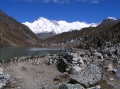
Day 13: Thangnak - Gokyo
Walking time |
2 hours |
Altitude gained |
50m |
Sleeping altitude |
4750m |
 The
weather and my dysentery both relapsed today. Mercifully though, the trek to Gokyo was short, although it was tougher than expected across the
Ngozumpa glacier. It didn't help that we were all still tired from the previous day's exertion and 2 nights of broken sleep. From Thangnak, the
path ascends the lateral moraine and drops onto the glacier where it picks a winding route around the crevasses and lakes to the lateral moraine
on the other side. After climbing over this, it drops down to meet the main Dole path between the first and second lakes. From here its 30 minutes
further to the third lake and Gokyo.
The
weather and my dysentery both relapsed today. Mercifully though, the trek to Gokyo was short, although it was tougher than expected across the
Ngozumpa glacier. It didn't help that we were all still tired from the previous day's exertion and 2 nights of broken sleep. From Thangnak, the
path ascends the lateral moraine and drops onto the glacier where it picks a winding route around the crevasses and lakes to the lateral moraine
on the other side. After climbing over this, it drops down to meet the main Dole path between the first and second lakes. From here its 30 minutes
further to the third lake and Gokyo.
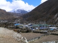
 Situated beside a
serene turquoise lake and surrounded by mountains, including Cho Oyo (the world's 6th highest peak), Gokyo really is an outstandingly beautiful place.
The village is large but attractive and has many good quality lodges to chose from. We chose the Gokyo Namaste Lodge which had
the warmest dinning room of the whole trek. We had planned to climb Gokyo Ri (a 5340m hill north of Gokyo) in the afternoon but were still too
tired from the Cho La to bother, so we read and played cards instead. For dinner I forced down a couple of mouthfuls of noodles before crawling into
bed. My symptoms worsened overnight but at least by now it was clear from the rotten egg smelling diarrhoea that I had Giardia. Although I felt
bad, I at least knew from past experience that recovery would come in a couple of days now that I had started the correct medication. That was little comfort
during the night when I was up
4 times to the toilet though.
Situated beside a
serene turquoise lake and surrounded by mountains, including Cho Oyo (the world's 6th highest peak), Gokyo really is an outstandingly beautiful place.
The village is large but attractive and has many good quality lodges to chose from. We chose the Gokyo Namaste Lodge which had
the warmest dinning room of the whole trek. We had planned to climb Gokyo Ri (a 5340m hill north of Gokyo) in the afternoon but were still too
tired from the Cho La to bother, so we read and played cards instead. For dinner I forced down a couple of mouthfuls of noodles before crawling into
bed. My symptoms worsened overnight but at least by now it was clear from the rotten egg smelling diarrhoea that I had Giardia. Although I felt
bad, I at least knew from past experience that recovery would come in a couple of days now that I had started the correct medication. That was little comfort
during the night when I was up
4 times to the toilet though.
Day 14: Gokyo - Mong La
Walking time |
7 hours |
Altitude lost |
777m |
Sleeping altitude |
4973m |
 I woke up feeling a little better
but not well enough to trek up to the 5th lake as planned. We therefore decided to split into 2 groups, my group would start the descent back to
Namche while the rest would trek to the 5th lake and either stay another night in Gokyo or somewhere further down. We'd then meet up in Namche in
2 days time. This way I would have 4 days, rather than 3, to make it back to Lukla if I was still struggling. The lodge owner had arranged for a
porter to carry my rucksack, at the bargain cost of Rs.500 per day, so I was feeling more confident about getting home than I was the day before.
The porter appeared at 9:30 once he had eaten his daal bhaat. He was in his teens and tiny - less than 5ft (1.5m) tall. Just as well my
pack was only about 12 kilos in weight. We said our farewells to each other and set off in our opposite directions.
I woke up feeling a little better
but not well enough to trek up to the 5th lake as planned. We therefore decided to split into 2 groups, my group would start the descent back to
Namche while the rest would trek to the 5th lake and either stay another night in Gokyo or somewhere further down. We'd then meet up in Namche in
2 days time. This way I would have 4 days, rather than 3, to make it back to Lukla if I was still struggling. The lodge owner had arranged for a
porter to carry my rucksack, at the bargain cost of Rs.500 per day, so I was feeling more confident about getting home than I was the day before.
The porter appeared at 9:30 once he had eaten his daal bhaat. He was in his teens and tiny - less than 5ft (1.5m) tall. Just as well my
pack was only about 12 kilos in weight. We said our farewells to each other and set off in our opposite directions.
 The trek started off painfully but we kept
up a good pace and were in Machermo within 2 hours. After the 1st lake, the glacier ends and the Dudh Koshi which emerges from it, cuts a steep
V-shaped valley through the jagged mountains on either side. It's a much more scenic route than the Imja Khola valley up to Gorak Shep. At Machermo,
there's a health post with a western doctor but the cost of treatment was expensive at $50 a consultation so I didn't bother getting one. The doc
wasn't in anyhow. A half hour further on we arrived in Luza where we stopped for lunch. I managed to eat a full bowl of soup which was a promising
sign. Another hour on we passed through Dole, a picturesque village with a number of smart looking lodges, situated above the forest on a
broadened ridge. From here the path descended through the forest to the river at Phortse Tenga. On the way we passed the national park office and
army check post, both of which were abandoned and vandalised, remnants of a Maoist attack perhaps. The lodges at Phortse Tenga were basic so
we decided to continue on to Mong La, a 300m climb back up the ridge. It was a tough end to the day but we made the top in only 45 minutes.
The trek started off painfully but we kept
up a good pace and were in Machermo within 2 hours. After the 1st lake, the glacier ends and the Dudh Koshi which emerges from it, cuts a steep
V-shaped valley through the jagged mountains on either side. It's a much more scenic route than the Imja Khola valley up to Gorak Shep. At Machermo,
there's a health post with a western doctor but the cost of treatment was expensive at $50 a consultation so I didn't bother getting one. The doc
wasn't in anyhow. A half hour further on we arrived in Luza where we stopped for lunch. I managed to eat a full bowl of soup which was a promising
sign. Another hour on we passed through Dole, a picturesque village with a number of smart looking lodges, situated above the forest on a
broadened ridge. From here the path descended through the forest to the river at Phortse Tenga. On the way we passed the national park office and
army check post, both of which were abandoned and vandalised, remnants of a Maoist attack perhaps. The lodges at Phortse Tenga were basic so
we decided to continue on to Mong La, a 300m climb back up the ridge. It was a tough end to the day but we made the top in only 45 minutes.
 Mong La is a 4
lodge hamlet straddling a pass at 3973m. It is one of the places on this trek that, if you get the chance, you really should try to visit. The views of Ama Dablam, Thamserku and Kang Tega were
particularly spectacular from here. We checked into the
Mountain View Lodge which did not fail to deliver on it's promises. We were given rooms with amazing mountain views and a precarious outlook over
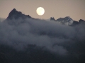
the Dudh Koshi that was almost enough to bring on vertigo. At dusk, we watched Ama Dablam change from white to gold in the setting sun, followed
by the full moon rising above Kang Tega. Then at night, the mountains were illuminated in a ghostly white and the Milky Way
was so clear and bright it looked like the Dudh Koshi was reflected in the sky.
Mong La is a 4
lodge hamlet straddling a pass at 3973m. It is one of the places on this trek that, if you get the chance, you really should try to visit. The views of Ama Dablam, Thamserku and Kang Tega were
particularly spectacular from here. We checked into the
Mountain View Lodge which did not fail to deliver on it's promises. We were given rooms with amazing mountain views and a precarious outlook over
the Dudh Koshi that was almost enough to bring on vertigo. At dusk, we watched Ama Dablam change from white to gold in the setting sun, followed
by the full moon rising above Kang Tega. Then at night, the mountains were illuminated in a ghostly white and the Milky Way
was so clear and bright it looked like the Dudh Koshi was reflected in the sky.
Day 15: Mong La - Namche
Walking time |
2 hours |
Altitude lost |
523m |
Sleeping altitude |
3450m |
I woke this morning to a stunning view of Thamserku without even having to leave the comfort of my sleeping bag. A little later I got my first ever glimpse of Nepal's national bird, the beautiful Impeyan pheasant, locally known as danphe. I had enjoyed my stay here at Mong La which was was especially memorable for me because it marked a turning point on my road to recovery from Giardia. Both the somersaulting intestines and unscheduled toilet trips had stopped and my appetite had returned to the extent that I was now able to eat a meal for the first time in 4 days. I half wished I hadn't been so hasty to descend and had instead gone to the 5th lake with the others. But then I would have missed out on the night here which, for me, was the best of the two options.
 The path from Mong La
continued south and descended around the side of the ridge to a fork where we saw a herd of Himalayan goats or tahr. From here, the quickest way to Namche is to take the left-hand trail via Sanasa.
The right-hand trail goes uphill to Khumjung. After Sanasa, the path joins the main
Tengboche trail and traverses around the hillside for what seems like ages before Namche comes into view. Along here, the views back up the valley
to Ama Dablam, Lhotse and Everest are impressive and made us realise what we had missed on the way up. At Namche, we booked into the Khumbu Lodge
on a recommendation and were not disappointed. It was a traditional lodge on the main street which had been extended over the years. The dinning
room was massive and beautifully decked out in varnished pine. Our 5 bed room was en suite, but without hot water, although this wasn't going to be
likely at Rs.100 each a night. As it turned out, it didn't matter because the
hotel had a gas-heated shower which cost Rs.200 for as long as you could spend in it. I had my first wash in 8 days! The 5th lake group turned up at
about 5pm having walked from Machermo the harder way via Khumjung.
The path from Mong La
continued south and descended around the side of the ridge to a fork where we saw a herd of Himalayan goats or tahr. From here, the quickest way to Namche is to take the left-hand trail via Sanasa.
The right-hand trail goes uphill to Khumjung. After Sanasa, the path joins the main
Tengboche trail and traverses around the hillside for what seems like ages before Namche comes into view. Along here, the views back up the valley
to Ama Dablam, Lhotse and Everest are impressive and made us realise what we had missed on the way up. At Namche, we booked into the Khumbu Lodge
on a recommendation and were not disappointed. It was a traditional lodge on the main street which had been extended over the years. The dinning
room was massive and beautifully decked out in varnished pine. Our 5 bed room was en suite, but without hot water, although this wasn't going to be
likely at Rs.100 each a night. As it turned out, it didn't matter because the
hotel had a gas-heated shower which cost Rs.200 for as long as you could spend in it. I had my first wash in 8 days! The 5th lake group turned up at
about 5pm having walked from Machermo the harder way via Khumjung.
Day 16: Namche - Lukla
Walking time |
6 hours |
Altitude lost |
600m |
Sleeping altitude |
2850m |
 We split
into 2 groups again today as the 5th lake crew decided to chill out in Namche while us Mong La lads wanted to push on to Lukla and reach
Kathmandu a day early. After breakfast, myself and the Lukla-bound group headed to the bakery for coffee and cakes. I reckoned I had lost about
3Kg over the previous 2 weeks, most of it while having Giardia, and I was on a mission to regain it now that my appetite was back. It was nearly 11am
by the time we left Namche and, fully aware of the distance ahead of us, we set off at a cracking pace. It took only 45 minutes to descend the big
hill that had taken us 3 hours to ascend on the way up. Despite the pace, we wasted a lot of time (1¼ hours)
waiting for our lunch to be cooked and then further time was lost while taking a detour around the Kusum Khola bridge at Tado Koshi. The bridge was being
repaired and we were angrily chucked off it by the foreman and sent on a massive diversion around the top. Fortunately, we didn't have to lose the
height gained and followed a higher path to Chaplung from where we rejoined the path to Lukla. It was dusk by the time we rolled into Lukla and we
headed straight for the North Face Resort which was run by the elder sister of the Khumbu Lodge sherpani. So similar were the two
sisters, we couldn't believe they weren't the same woman at first. The Khumbu Lodge sherpani had
phoned her sister that morning to book us
in and request her to rearrange our flights with the airline. This she had done which was just as well since the office was already closed. All
that was left for us to do was shower and feast on bottled beer and sizzling yak steaks.
We split
into 2 groups again today as the 5th lake crew decided to chill out in Namche while us Mong La lads wanted to push on to Lukla and reach
Kathmandu a day early. After breakfast, myself and the Lukla-bound group headed to the bakery for coffee and cakes. I reckoned I had lost about
3Kg over the previous 2 weeks, most of it while having Giardia, and I was on a mission to regain it now that my appetite was back. It was nearly 11am
by the time we left Namche and, fully aware of the distance ahead of us, we set off at a cracking pace. It took only 45 minutes to descend the big
hill that had taken us 3 hours to ascend on the way up. Despite the pace, we wasted a lot of time (1¼ hours)
waiting for our lunch to be cooked and then further time was lost while taking a detour around the Kusum Khola bridge at Tado Koshi. The bridge was being
repaired and we were angrily chucked off it by the foreman and sent on a massive diversion around the top. Fortunately, we didn't have to lose the
height gained and followed a higher path to Chaplung from where we rejoined the path to Lukla. It was dusk by the time we rolled into Lukla and we
headed straight for the North Face Resort which was run by the elder sister of the Khumbu Lodge sherpani. So similar were the two
sisters, we couldn't believe they weren't the same woman at first. The Khumbu Lodge sherpani had
phoned her sister that morning to book us
in and request her to rearrange our flights with the airline. This she had done which was just as well since the office was already closed. All
that was left for us to do was shower and feast on bottled beer and sizzling yak steaks.
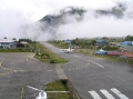
Day 17: Lukla - Kathmandu
 Our new
flight was at 7:15 on the "second flight" of the morning. The flight numbering is confusing since most airlines operate the sector with 2 aircraft
so each flight is actually 2 planes together. We watched in horror from the hotel as the second Yeti plane came into land 2 hours too early and we thought
we'd missed our flight until we realised this. It was fascinating yet unnerving watching the air traffic operation at Lukla. Every couple of hours
from about 5am to 11am, over a dozen planes come into land on this tiny airstrip within 20 minutes, and the terminal has only enough
room for 4 planes on the ground at once. This means some slick air traffic control and some very fast turnaround times by the flight crew and
ground staff. Amazingly for Nepal, they succeed, and without any accidents, which is hard to believe when you see planes taking off into the path
of others on their landing approach before banking sharply left to avoid
them.
Our new
flight was at 7:15 on the "second flight" of the morning. The flight numbering is confusing since most airlines operate the sector with 2 aircraft
so each flight is actually 2 planes together. We watched in horror from the hotel as the second Yeti plane came into land 2 hours too early and we thought
we'd missed our flight until we realised this. It was fascinating yet unnerving watching the air traffic operation at Lukla. Every couple of hours
from about 5am to 11am, over a dozen planes come into land on this tiny airstrip within 20 minutes, and the terminal has only enough
room for 4 planes on the ground at once. This means some slick air traffic control and some very fast turnaround times by the flight crew and
ground staff. Amazingly for Nepal, they succeed, and without any accidents, which is hard to believe when you see planes taking off into the path
of others on their landing approach before banking sharply left to avoid
them.
Check-in was the usual chaos you'd expect at a Nepali airport but at least nobody questioned us about our tickets showing a different date. The security check was also a farce. Instead of the x-ray scanner, there was a line of disinterested policemen looking at, and occasionally peering into, rucksacks. On the flight were the same 3 Americans who'd been on our outward flight and on the trail with us most of the way round the Khumbu. We arranged to meet them later for beers.
That afternoon the fine weather broke and it rained heavily well into the night. We were worried the next day's Lukla flights would be grounded and that the rest of the group would be stranded and maybe even miss their flight home. By good fortune though, it cleared for a brief period the next morning which was just long enough for the flights to operate and for the guys to get out. From thereafter it rained continuously for the next 2 days and didn't clear until the day we left Nepal.
© Steven Flower 2012
