 |
|||||||||||||||||||||||||||||||||||||||||||||||||||||||||||||||||||||||||||||||||||||||||||||||||||||
|
|||||||||||||||||||||||||||||||||||||||||||||||||||||||||||||||||||||||||||||||||||||||||||||||||||||
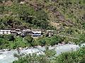
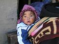
We followed the guide to the Peaceful Guesthouse which had a spacious dining room, hot shower and excellent daal bhaat which we ate with chicken curry that had not long before been a hen happily scratching around the yard. We were completely shattered after the long walk and turned in again at 9pm. Day 3: Tal - Dharapani
|
| Walking time | 2 hours |
| Sleeping altitude | 1860m |
| Altitude change | 160m |
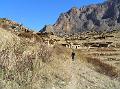
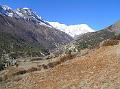
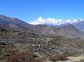
The plan today was to reach Koto at the start of the Naar-Phu valley which would have been another full day on the trail. However, circumstances dictated otherwise when Richard seriously injured his ankle and called an abrupt end to his trek only 2 hours into the day. It had started off well enough even though we had woken late at 6am still tired and stiff from the previous day's epic. We got on the trail at 7:20 and pushed through the stiffness to reach Kkotro in just over an hour where we stopped for breakfast. We moving well and were making good time to the next village of Dharapani, which I foolishly remarked out loud to Richard. At which point his foot slipped sideways off a protruding rock and he went down to the ground with a cry of pain. After the initial pain had subsided, he managed to get back on his feet and was able to hobble the last 15 minutes into Dharapani. On the way, the peak of Manaslu became visible up the Dudh Khola valley although it was hard to get too excited about it.
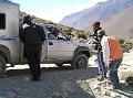
We stopped at the check post where Richard took off his boot to reveal a swollen ankle the size of a grapefruit. We knew immediately that he was going no further and we'd need to stop here and arrange some kind of evacuation. We checked into the Tibetan Lodge and spent the afternoon making phone calls to Govinda at the agency and to the insurance company back in the UK. A helicopter was arranged at a cost of US$1,500 per hour which would arrive the next morning from Kathmandu. The hotel owner had been very helpful and had also booked us a helicopter so we had 2 coming at one point until we realised this and cancelled one. We discussed whether I would return on the helicopter with Richard but he insisted I should go on. We agreed I would to go on to Naar-Phu as it was so close and then we would meet up in Pokhara in 8 days time. This meant I'd need to trek quickly and bring forward the flight out of Jomosom. Richard said he'd go to Chitwan for a safari after taking a few days rest in Kathmandu. I realised that the plan to cross the mountains at Tilicho Lake was too risky to do alone and the camping equipment we were sharing between us would have been too heavy for me to have carried by myself. We donated the food and petrol to the hotel and I gave Richard the tent, stove and other surplus items to take back on the helicopter. I did try to explain to the hotel sauji that petrol wasn't the same as kerosene and couldn't be used in the local stoves. I do hope he understood. We ate a delicious daal bhaat at the hotel and both retired to bed feeling rather depressed.
Day 4: Dharapani - Koto
| Walking time | 4 hours |
| Sleeping altitude | 2600m |
| Altitude change | 740m |
 We got up at 6:30 and had breakfast before wandering (limping in
Richard's case) slowly down to the school where the helicopter would
land. We had been told it was leaving at 7am so expected it to land at
8am, but it was 8:20 when it showed up, adding another hour to the cost
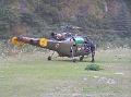
($1,500 per hour to be exact!). For some reason we had expected a
private charter and were surprised when a Nepalese Army Alouette showed
up. It was a tiny aircraft seating 2 aircrew and 3 passengers which was
probably just as well given the size of the school yard it had to land
in. The airmen were textbook top guns with their aviator specs,
immaculate uniforms and narcissistic swaggers. Once the rotors were
stopped, two local women casually got off with bags of luggage and
groceries as as if they'd just been on the bus. They were friends of the
lodge owner who had resourcefully hitched a ride (he had politely
checked with us that this was OK which of course it was). I could tell
poor Richard was crapping himself as he climbed inside so my own look of
terror probably didn't help much. We said a brief goodbye before the
door was shut and I was beckoned to stand back by the crewmen. The
helicopter made a wobbly take-off, tilted it's nose downward and then
headed down the valley through a narrow gap between a tree and the cliff. I was terrified just watching and fully
expected never to see Richard again.
We got up at 6:30 and had breakfast before wandering (limping in
Richard's case) slowly down to the school where the helicopter would
land. We had been told it was leaving at 7am so expected it to land at
8am, but it was 8:20 when it showed up, adding another hour to the cost
($1,500 per hour to be exact!). For some reason we had expected a
private charter and were surprised when a Nepalese Army Alouette showed
up. It was a tiny aircraft seating 2 aircrew and 3 passengers which was
probably just as well given the size of the school yard it had to land
in. The airmen were textbook top guns with their aviator specs,
immaculate uniforms and narcissistic swaggers. Once the rotors were
stopped, two local women casually got off with bags of luggage and
groceries as as if they'd just been on the bus. They were friends of the
lodge owner who had resourcefully hitched a ride (he had politely
checked with us that this was OK which of course it was). I could tell
poor Richard was crapping himself as he climbed inside so my own look of
terror probably didn't help much. We said a brief goodbye before the
door was shut and I was beckoned to stand back by the crewmen. The
helicopter made a wobbly take-off, tilted it's nose downward and then
headed down the valley through a narrow gap between a tree and the cliff. I was terrified just watching and fully
expected never to see Richard again.
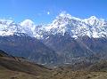
 I returned to the lodge where I said my goodbyes and got straight on the
trail to Koto. It was an uneventful hour to Danakyu after which there was a
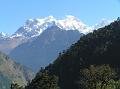
1 hour climb to Timang which opened up magnificent views of the Manaslu
range. After another hour of slight incline through pine forest, I reached
Thachok where I stopped for lunch at the Himalayan lodge. I met up with Dave
and Kath, the couple we'd waded through the Marsyangdi with, and walked with
them for a while before taking off to reach Koto in an hour. I stopped at
the first lodge where I was greeted by a group of locals who were sat in the
front garden drinking beer and raksi in celebration of the owner's
son's first birthday. I joined them to eat some birthday cake and then went
to call Govinda to find that Richard had arrived safely and had been taken
straight to hospital where his leg was cast in plaster for a suspected
fracture. I washed some clothes and had a shower and then walked up to Chame,
20 minutes further up the trail.
I returned to the lodge where I said my goodbyes and got straight on the
trail to Koto. It was an uneventful hour to Danakyu after which there was a
1 hour climb to Timang which opened up magnificent views of the Manaslu
range. After another hour of slight incline through pine forest, I reached
Thachok where I stopped for lunch at the Himalayan lodge. I met up with Dave
and Kath, the couple we'd waded through the Marsyangdi with, and walked with
them for a while before taking off to reach Koto in an hour. I stopped at
the first lodge where I was greeted by a group of locals who were sat in the
front garden drinking beer and raksi in celebration of the owner's
son's first birthday. I joined them to eat some birthday cake and then went
to call Govinda to find that Richard had arrived safely and had been taken
straight to hospital where his leg was cast in plaster for a suspected
fracture. I washed some clothes and had a shower and then walked up to Chame,
20 minutes further up the trail.
 Chame is the district headquarters in
Manang and has all the same touristy stuff that Namche had in Solukumbhu
(craft shops, pool bars, internet cafes etc.). I was glad I was staying in
Koto. I bumped into Dave and his guide and went for some raksi and
sukuti (fried dry meat) before returning to Koto to find that my hotel
had been taken over by a big group of noisy Italians. I took a table in the restaurant
but
was recognised by a villager I'd met on the trail and was beckoned into the
kitchen to drink raksi around the fire with the guides and porters.
The villagers here were ethnically Tibetan and some of the friendliest
people I met on the trek. An old man I'd met on the trail kept sharing his
glass with me which would never happen in Hindu households. They were
fascinated (or pretended to be anyway) with my Nepali chat and wanted to
know all the usual facts about me. Things started to liven up when one of
the porters was chucked out for being too drunk and argumentative. Then an
old relative of the family who was already drunk came in for another a
raksi and then fell asleep. He too was chucked out. They kept using me
as an excuse as if I'd be offended by it. It was hilarious. After several
glasses of raksi, the daal bhaat arrived which I ate round the
fire with the Nepalis, while the Italian group ate their imitation pasta
dishes out in the restaurant. This was the real Nepal and the reason I love
this country so much. I went to bed at 20:15 feeling full of bhaat
and a wee bit bit drunk. The Italians woke me up 1.5 hours later stomping
around the wooden floors and shouting at each other from room to room.
Chame is the district headquarters in
Manang and has all the same touristy stuff that Namche had in Solukumbhu
(craft shops, pool bars, internet cafes etc.). I was glad I was staying in
Koto. I bumped into Dave and his guide and went for some raksi and
sukuti (fried dry meat) before returning to Koto to find that my hotel
had been taken over by a big group of noisy Italians. I took a table in the restaurant
but
was recognised by a villager I'd met on the trail and was beckoned into the
kitchen to drink raksi around the fire with the guides and porters.
The villagers here were ethnically Tibetan and some of the friendliest
people I met on the trek. An old man I'd met on the trail kept sharing his
glass with me which would never happen in Hindu households. They were
fascinated (or pretended to be anyway) with my Nepali chat and wanted to
know all the usual facts about me. Things started to liven up when one of
the porters was chucked out for being too drunk and argumentative. Then an
old relative of the family who was already drunk came in for another a
raksi and then fell asleep. He too was chucked out. They kept using me
as an excuse as if I'd be offended by it. It was hilarious. After several
glasses of raksi, the daal bhaat arrived which I ate round the
fire with the Nepalis, while the Italian group ate their imitation pasta
dishes out in the restaurant. This was the real Nepal and the reason I love
this country so much. I went to bed at 20:15 feeling full of bhaat
and a wee bit bit drunk. The Italians woke me up 1.5 hours later stomping
around the wooden floors and shouting at each other from room to room.
Day 5: Koto - Meta
| Walking time | 6.5 hours |
| Sleeping altitude | 3560m |
| Altitude change | 960m |
After a fitful night's sleep thanks to noisy Italians and a painfully full bladder which I had tried to ignore, I woke at 5:45 to the sound of the dreaded radio. While I have a bad habit of cursing the presence of technology up here in the Himalaya, I have used the phone a lot on this trek. I wanted to call Suzie and the kids but it was 1:30am at home so thought better of it. I should have called last night as this might have been my last chance for 4 days if there were no phones in Phu or Naar. My stomach didn't feel great this morning but at least yesterday's headache had gone. I had hoped that the headache was from dehydration or sunburn rather than from altitude as it was only 2600m here. After a couple of urgent trips to the toilet, my stomach started to feel a bit better so I laid of the Norfloxacin for the time being.
At 7am the Italians came down for their breakfast which was my cue to get on the trail asap. I had some tea and a bowl of porridge around the fire and then made a couple of calls. I left the hotel at the back of 8am and had travelled a whole 20m down the village before having to stop to have my permits checked. The policeman was concerned about me going up to Naar-Phu alone so escorted me down to the Police Station to consult with the top brass. Naar-Phu is a restricted region and only guided trekking groups are supposed to be allowed in, so maybe it was now my turn to be going home early. As it turned out, the Detective Superintendent was pretty laid back and just wanted to chat over a cup of tea. It probably helped that I spoke Nepali and was exceptionally polite. On my way out, he asked me where my stick was which was a stroke of luck as I had left it back at the hotel. I ran back to find that the hotel sauji had already acquired it. He reluctantly gave it back and after collecting my rucksack from the police station, I finally got on the trail at 8:30.
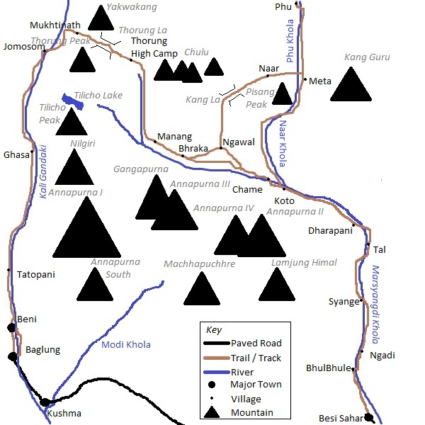
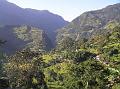
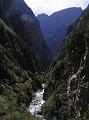
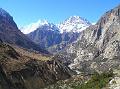
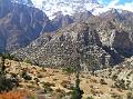
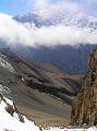
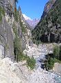 The valley to Naar-Phu is a formidable looking notch in the Marsyangdi
valley cliffs that snakes it's way north to the Tibetan border. The trail
stays close to the valley bottom for the first 5½ hours before climbing the
last hour up to Meta at 3560m. Despite being enclosed in the gorge for the
majority of the trek, it is a spectacular walk and some early views of Pisang Peak are afforded in the first couple of hours. There were few water
sources along the trail during October so carry at least 2 litres and fill
up at every opportunity.
The valley to Naar-Phu is a formidable looking notch in the Marsyangdi
valley cliffs that snakes it's way north to the Tibetan border. The trail
stays close to the valley bottom for the first 5½ hours before climbing the
last hour up to Meta at 3560m. Despite being enclosed in the gorge for the
majority of the trek, it is a spectacular walk and some early views of Pisang Peak are afforded in the first couple of hours. There were few water
sources along the trail during October so carry at least 2 litres and fill
up at every opportunity.
 The trail started off in pine forest which was being actively managed for
timber. The lumber was milled on site and the planks were immaculately
stacked by the side of the path. After an hour, there was a fork in the
trail with 2 equal looking paths leading in both directions. Rather than
guess and waste time and energy, I waited for a group of locals I had passed
earlier to catch up and show me the right way. It was the lower (right)
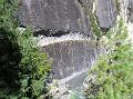
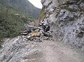
trail. From here the trek continued in and out of the forest onto dynamite
blasted cliff-side trails high above the Naar Khola where the gorge
narrowed. The quality of the path was surprisingly good for this being a
remote region although there was a lot more traffic going up and down than I
had expected, both local and tourist. It was still a tranquil paradise
compared to the circus and having a few humans around was reassuring in case
anything went wrong. In fact, one of the acquaintances I met quite early on
in the day would become my trekking companion for the next 2 days.
The trail started off in pine forest which was being actively managed for
timber. The lumber was milled on site and the planks were immaculately
stacked by the side of the path. After an hour, there was a fork in the
trail with 2 equal looking paths leading in both directions. Rather than
guess and waste time and energy, I waited for a group of locals I had passed
earlier to catch up and show me the right way. It was the lower (right)
trail. From here the trek continued in and out of the forest onto dynamite
blasted cliff-side trails high above the Naar Khola where the gorge
narrowed. The quality of the path was surprisingly good for this being a
remote region although there was a lot more traffic going up and down than I
had expected, both local and tourist. It was still a tranquil paradise
compared to the circus and having a few humans around was reassuring in case
anything went wrong. In fact, one of the acquaintances I met quite early on
in the day would become my trekking companion for the next 2 days.
 About 2 hours out of Koto, the pine forest became intermixed with spruce
and autumnal maple and after a further 4 hours, changed to birch and yew. Pisang Peak
had been visible to the north for the first couple of hours but had been
lost as the gorge had closed in. After 4½ hours the trail arrived at Dharamsala, not the Indian home to the Dalai Lama, but an ACAP camping site.
By now I had met up with Yam Bahadur Gharti Magar who was a Khane Pani (drinking
water) Office Technician at Chame. Coincidentally, he was from a village called Mudi where I
had stayed 13 years previously while trekking the
Dhaulagiri circuit.
About 2 hours out of Koto, the pine forest became intermixed with spruce
and autumnal maple and after a further 4 hours, changed to birch and yew. Pisang Peak
had been visible to the north for the first couple of hours but had been
lost as the gorge had closed in. After 4½ hours the trail arrived at Dharamsala, not the Indian home to the Dalai Lama, but an ACAP camping site.
By now I had met up with Yam Bahadur Gharti Magar who was a Khane Pani (drinking
water) Office Technician at Chame. Coincidentally, he was from a village called Mudi where I
had stayed 13 years previously while trekking the
Dhaulagiri circuit.
 After 5.5 hours where the gorge narrows and becomes impassable, the path
climbs to the east up a tributary to a large terrace on the western slope of
Kang Guru. It was a hard 30 minute slog to the rim of the gorge and then
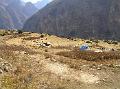
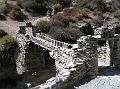
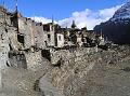
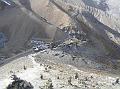
another 20 minutes through fields to Meta at the top of the terrace. The village is a semi-permanent settlement used during the rainy season
by Naar folk who grow crops and graze their yaks on the land around here.
The houses are Tibetan style with a flat-roofed, windowless, dry stone
construction and randomly attached to form a maze of narrow interconnecting
pathways. Livestock are housed at ground level while the accommodation is
located on the floor above. Some buildings were in a poor state of repair
and had probably been abandoned. The rainy season had ended 1 month earlier and
the village was deserted except for the lively lodge and the campsite
on the ground below. The land was already so barren, it was hard to imagine
that it could sustain any human life at all.
After 5.5 hours where the gorge narrows and becomes impassable, the path
climbs to the east up a tributary to a large terrace on the western slope of
Kang Guru. It was a hard 30 minute slog to the rim of the gorge and then
another 20 minutes through fields to Meta at the top of the terrace. The village is a semi-permanent settlement used during the rainy season
by Naar folk who grow crops and graze their yaks on the land around here.
The houses are Tibetan style with a flat-roofed, windowless, dry stone
construction and randomly attached to form a maze of narrow interconnecting
pathways. Livestock are housed at ground level while the accommodation is
located on the floor above. Some buildings were in a poor state of repair
and had probably been abandoned. The rainy season had ended 1 month earlier and
the village was deserted except for the lively lodge and the campsite
on the ground below. The land was already so barren, it was hard to imagine
that it could sustain any human life at all.
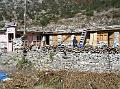 Meta's
only lodge, the Kang Guru Hotel, is the smartest looking building at the top
end of the village. Yam and I checked in to our shared room and had tea in the
afternoon sunshine. Afterwards, I went for a wander around to
take in the sights and chillax after the long walk. It was a lofty place
with impressive views in both directions up and down the Naar Khola. To the north was a barren
mountain terrain typical of the Himalayan rain shadow while to the south
was a magnificent view down the forested gorge I had just walked up, with Lamjung
Himal as a backdrop. Below the village, on some flat ground was the campsite
where 2 guided groups, both French, had set up camp. I wandered down and
chatted with some of the Nepalese staff until the sun dropped behind the big
lump of rock across the valley. I returned to the lodge to put on warmer
clothes and set up base beside the kitchen fire, stooped beneath hanging
strips of yak meat curing in the unventilated wood smoke. I was the only
foreigner staying in the hotel but the place was packed full with porters,
mule train drivers, locals, and government officials all moving between Phu
and the Marsyangdi valley. There was only one young sauni to cater for
all the demands for raksi and daal bhaat which she did
remarkably well. I drank a few glasses of raksi and chatted with a couple of
guys from one of the French groups who had came up for bhaat. I
treated myself to a plate of the dried yak meat sukuti with my daal
bhaat and retired to bed at 19:45.
Meta's
only lodge, the Kang Guru Hotel, is the smartest looking building at the top
end of the village. Yam and I checked in to our shared room and had tea in the
afternoon sunshine. Afterwards, I went for a wander around to
take in the sights and chillax after the long walk. It was a lofty place
with impressive views in both directions up and down the Naar Khola. To the north was a barren
mountain terrain typical of the Himalayan rain shadow while to the south
was a magnificent view down the forested gorge I had just walked up, with Lamjung
Himal as a backdrop. Below the village, on some flat ground was the campsite
where 2 guided groups, both French, had set up camp. I wandered down and
chatted with some of the Nepalese staff until the sun dropped behind the big
lump of rock across the valley. I returned to the lodge to put on warmer
clothes and set up base beside the kitchen fire, stooped beneath hanging
strips of yak meat curing in the unventilated wood smoke. I was the only
foreigner staying in the hotel but the place was packed full with porters,
mule train drivers, locals, and government officials all moving between Phu
and the Marsyangdi valley. There was only one young sauni to cater for
all the demands for raksi and daal bhaat which she did
remarkably well. I drank a few glasses of raksi and chatted with a couple of
guys from one of the French groups who had came up for bhaat. I
treated myself to a plate of the dried yak meat sukuti with my daal
bhaat and retired to bed at 19:45.
Day 6: Meta - Phu
| Walking time | 5 hours |
| Sleeping altitude | 4100m |
| Altitude change | 540m |
After a couple of hours sleep, I was awakened by one of the drunk porters banging on our room door after which I had another restless night thanks to Yam's snoring, a painfully thin mattress, a couple of heart thumping altitude anxiety moments and a nagging need to piss. I was glad when it was light and I could finally get up. Yam and I had noodle soup for breakfast and hit the trail at 7:30.
 It was a flat 1¼ hours walk through juniper and thorn
scrub to the next seasonal settlement, Junum. The view back to Pisang Peak
with the long, steep path across it's lower slopes was impressive from here.
An hour later we reached Chyaka, another abandoned seasonal settlement high
above the Phu Khola. After Chyaka where the trail forks, we took the upper
(right) path which climbed steeply to the top of a small moraine ridge (the
lower path used by mule trains is less steep but longer). After descending
the ridge, the path forked again. Yam directed us to go right but this led
to a stream which was too icy to cross. We had to back-track to the fork and
take the lower path to the bridge. It was a hard 15 minute climb up the next
moraine ridge from which you descend into Kyang. We stopped here with a
couple of porters to eat snacks and rest. From Chyaka it had taken 45
minutes to reach Kyang and according to the ACAP sign board here, the
altitude was 3840m. Yam was proud to inform me that he had installed the
drinking water taps here. I think he was a bit embarrassed when the water
came out brown.
It was a flat 1¼ hours walk through juniper and thorn
scrub to the next seasonal settlement, Junum. The view back to Pisang Peak
with the long, steep path across it's lower slopes was impressive from here.
An hour later we reached Chyaka, another abandoned seasonal settlement high
above the Phu Khola. After Chyaka where the trail forks, we took the upper
(right) path which climbed steeply to the top of a small moraine ridge (the
lower path used by mule trains is less steep but longer). After descending
the ridge, the path forked again. Yam directed us to go right but this led
to a stream which was too icy to cross. We had to back-track to the fork and
take the lower path to the bridge. It was a hard 15 minute climb up the next
moraine ridge from which you descend into Kyang. We stopped here with a
couple of porters to eat snacks and rest. From Chyaka it had taken 45
minutes to reach Kyang and according to the ACAP sign board here, the
altitude was 3840m. Yam was proud to inform me that he had installed the
drinking water taps here. I think he was a bit embarrassed when the water
came out brown.
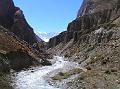 We left Kyang at 11:15 and climbed up to a cliff side
trail which then headed back down to the river. The path followed the
river, more or less, for 1½ hours, occasionally climbing up and down steep
scree. At the big rock pillar we climbed a steep trail for 10 minutes to a
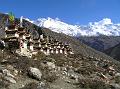
gate. I could sense that we were close to Phu by the increased frequency of
chortens and signs of cultivation. From the gate it was another ½ hour to
Phu on an easy trail.
We left Kyang at 11:15 and climbed up to a cliff side
trail which then headed back down to the river. The path followed the
river, more or less, for 1½ hours, occasionally climbing up and down steep
scree. At the big rock pillar we climbed a steep trail for 10 minutes to a
gate. I could sense that we were close to Phu by the increased frequency of
chortens and signs of cultivation. From the gate it was another ½ hour to
Phu on an easy trail.
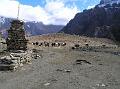
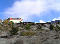
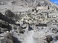 Phu is an amazing village of Tibetan style flat-roofed
stone houses built up against each other over a small hill at 4100m. The lack
of electricity cables gave the village an authentic medieval look and if it
weren't for the glass windows and a few water heating solar panels giving
away the arrival of some modernity, it looked as if it were unchanged in
over 500 years. The valley is wider here and there are snowy mountains
visible in 3 directions with Kang Guru dominating in the south, Himlung
Himal in the east and the mass of mountains which border Tibet in the north.
It was a truly breath taking place.
Phu is an amazing village of Tibetan style flat-roofed
stone houses built up against each other over a small hill at 4100m. The lack
of electricity cables gave the village an authentic medieval look and if it
weren't for the glass windows and a few water heating solar panels giving
away the arrival of some modernity, it looked as if it were unchanged in
over 500 years. The valley is wider here and there are snowy mountains
visible in 3 directions with Kang Guru dominating in the south, Himlung
Himal in the east and the mass of mountains which border Tibet in the north.
It was a truly breath taking place.
 The only lodge in the village was shut so we went to a
house where Yam knew the owners and had noodle soup and salted Tibetan tea.
Previous experiences of rancid yak butter had put me off Tibetan tea but
this time the butter was fresh so I had 5 cups! I enquired about a phone and
was surprised to learn that there was a working satellite phone in the
village. Unfortunately, like the lodge, this was also shut. After tea, Yam
and I left our bags at the house and went for a wander up to the gompa
which was across the river and up the opposite hill. The views from the
gompa were even more spectacular than from Phu. We looked around the
prayer room and left a donation before returning to the village.
The only lodge in the village was shut so we went to a
house where Yam knew the owners and had noodle soup and salted Tibetan tea.
Previous experiences of rancid yak butter had put me off Tibetan tea but
this time the butter was fresh so I had 5 cups! I enquired about a phone and
was surprised to learn that there was a working satellite phone in the
village. Unfortunately, like the lodge, this was also shut. After tea, Yam
and I left our bags at the house and went for a wander up to the gompa
which was across the river and up the opposite hill. The views from the
gompa were even more spectacular than from Phu. We looked around the
prayer room and left a donation before returning to the village.
 The lodge
still hadn't opened so we went back to the house to sit around the fire as
the sun had now dropped behind the mountains making it suddenly very cold.
The rest of the Water Office staff arrived at 17:00 but still no lodge owner
or telecoms office staff had showed up. At 17:30, the lodge didi
arrived home from the fields and we moved our bags to the room and drank
some more butter tea. At about 18:00, someone shouted across to tell us that
the phone office bahini was back so I went up to make a call
home. The phone "office" was a small, dark store room with a phone on a
table. I called to Govinda to get an update on Richard and then called home
to Suzie. It was great to talk with her although we spent most of the call
talking about Richard and I didn't get to hear what the kids were doing. The
cost was surprisingly cheap for a sat phone at 100 Rs per minute although
the reception wasn't so great.
The lodge
still hadn't opened so we went back to the house to sit around the fire as
the sun had now dropped behind the mountains making it suddenly very cold.
The rest of the Water Office staff arrived at 17:00 but still no lodge owner
or telecoms office staff had showed up. At 17:30, the lodge didi
arrived home from the fields and we moved our bags to the room and drank
some more butter tea. At about 18:00, someone shouted across to tell us that
the phone office bahini was back so I went up to make a call
home. The phone "office" was a small, dark store room with a phone on a
table. I called to Govinda to get an update on Richard and then called home
to Suzie. It was great to talk with her although we spent most of the call
talking about Richard and I didn't get to hear what the kids were doing. The
cost was surprisingly cheap for a sat phone at 100 Rs per minute although
the reception wasn't so great.
We returned to the hotel for a beer and sukuti which was like bits of fried leather but tasty enough bar a couple of rotten bits. After eating the daal bhaat with potato and cabbage curry, there was noting left to do so we went to bed. I think I must have been snoring loudly as I woke up with a jolt. Perhaps Yam had shouted at me. I had my earplugs in so would have been none the wiser. After that I lay fighting the need for a piss and eventually got up into the cold, clear night to go. The sky was a mass of brilliant white stars - you would never know that there were so many from what we see here in the UK. After the pee, I had a much better night's sleep with no symptoms of AMS at all.
Day 7: Phu - Naar
| Walking time | 6 hours |
| Sleeping altitude | 4110m |
| Altitude change | 10m |
I got up at 6:10 for an urgent trip to the smelly drop toilet and returned to the kitchen for an omelette breakfast. I settled up my bill which was more expensive than I had expected but then the beer alone was 350 Rs - inflated by the extra porterage charge. Don't get me wrong, I didn't grudge the cost; it was still well affordable by western standards. Life is tough this deep into the mountains and the limited income from visitors is a much needed boost to the economy. All tourists (bar me) come here on camping treks so lodges and teahouses rely on Nepalese custom for most of their earnings. I would like to have spent another night at Phu and explored the valley up to the Himlung Base Camp, but I was on a mission to meet up with Richard so didn't hang about longer.
 Having said my farewells to Yam and the didi, I left the lodge at
7:25 and started the walk back down the trail alone. Now that I knew the way
(not that you can go wrong much), I wasn't worried. That said, I did miss
Yam today. Although we didn't really chat much on the way up,
he had been good company and it had been reassuring that he was there in
case something had gone wrong. The main risk of trekking alone for me was
having no one to seek help if I fell off a high trail and was injured. There
was
enough traffic on the trail to ensure someone would find me and raise the
alarm if I sprained an ankle or something similar, but if I miraculously
survived a fall into
the gorge, it would be slow, lonely death.
Having said my farewells to Yam and the didi, I left the lodge at
7:25 and started the walk back down the trail alone. Now that I knew the way
(not that you can go wrong much), I wasn't worried. That said, I did miss
Yam today. Although we didn't really chat much on the way up,
he had been good company and it had been reassuring that he was there in
case something had gone wrong. The main risk of trekking alone for me was
having no one to seek help if I fell off a high trail and was injured. There
was
enough traffic on the trail to ensure someone would find me and raise the
alarm if I sprained an ankle or something similar, but if I miraculously
survived a fall into
the gorge, it would be slow, lonely death.
 I was walking quickly today and reach Kyang in 1¾
hours, half an hour quicker than on the way up. This time I had gravity on
my side and no companion to wait for. I also wasn't stopping to take
photographs as the light was still too low and I had taken all the ones I
needed on the way up. After a 15 minute rest at Kyang, I set off at 9:25 to
tackle the 2 moraine ridges which were just as tough to climb the second
time round. Ten minutes on from the wooden bridge at the base of the second ridge,
the path forked. This was were the new mule trail joined the main trekking
trail at it's northern end. Needless to say, I took the shorter, steeper
trail to the left and was in Chyaka by 10:10, 45 minutes from Kyang. Chyaka
looked like it was a permanent settlement once; one building looked like it
might even have been a school. Yam had told me on the way up that the
terraced fields around the village used to be khet (irrigated) until the water
dried up.
I was walking quickly today and reach Kyang in 1¾
hours, half an hour quicker than on the way up. This time I had gravity on
my side and no companion to wait for. I also wasn't stopping to take
photographs as the light was still too low and I had taken all the ones I
needed on the way up. After a 15 minute rest at Kyang, I set off at 9:25 to
tackle the 2 moraine ridges which were just as tough to climb the second
time round. Ten minutes on from the wooden bridge at the base of the second ridge,
the path forked. This was were the new mule trail joined the main trekking
trail at it's northern end. Needless to say, I took the shorter, steeper
trail to the left and was in Chyaka by 10:10, 45 minutes from Kyang. Chyaka
looked like it was a permanent settlement once; one building looked like it
might even have been a school. Yam had told me on the way up that the
terraced fields around the village used to be khet (irrigated) until the water
dried up.
 After a 10 minute rest, I left for Junum and arrived
20 minutes later at 10:40. From Junum, it was a 45 minute walk to the fork
in the path where I turned right for the bridge to Naar. This route is
considerably quicker than continuing on to the sign-posted route nearer to
Meta. Why ACAP didn't sign-post this closer trail is a mystery. Without a
guide it would be pretty hard to tell it apart from a grazing track. Luckily
for me, Yam had pointed it out to me on the way up. On the way to the bridge, I
gave most of my last bottle of water away to some thirsty porters and hoped
I was going to find more before the hard climb up to Naar.
After a 10 minute rest, I left for Junum and arrived
20 minutes later at 10:40. From Junum, it was a 45 minute walk to the fork
in the path where I turned right for the bridge to Naar. This route is
considerably quicker than continuing on to the sign-posted route nearer to
Meta. Why ACAP didn't sign-post this closer trail is a mystery. Without a
guide it would be pretty hard to tell it apart from a grazing track. Luckily
for me, Yam had pointed it out to me on the way up. On the way to the bridge, I
gave most of my last bottle of water away to some thirsty porters and hoped
I was going to find more before the hard climb up to Naar.
 From the fork, it
was a 20 minute descent down steep moraine to the bridge across the Phu
Khola. There were actually 2 bridges here; a rickety traditional wooden
bridge and a new galvanised steel suspension bridge, both built side by side
where the gorge narrows to only 10-15m wide. Naturally I crossed on the
suspension bridge although this was enough to give me the fear when I looked down
to the river at least 50m below. There was no water at
the campsite up from the bridge so I climbed for 10 minutes and took the
left path to the where a new gompa was being constructed and I
refilled my bottles there. I then climbed straight up for 10 minutes to
rejoin the main path. After 30 minutes of hard ascent, I reached a gate,
just after which there was a goTh and a running tap! I had
been misinformed that there was no water on the path up to Naar. This would
have saved me a half hour detour had I received better information!
From the fork, it
was a 20 minute descent down steep moraine to the bridge across the Phu
Khola. There were actually 2 bridges here; a rickety traditional wooden
bridge and a new galvanised steel suspension bridge, both built side by side
where the gorge narrows to only 10-15m wide. Naturally I crossed on the
suspension bridge although this was enough to give me the fear when I looked down
to the river at least 50m below. There was no water at
the campsite up from the bridge so I climbed for 10 minutes and took the
left path to the where a new gompa was being constructed and I
refilled my bottles there. I then climbed straight up for 10 minutes to
rejoin the main path. After 30 minutes of hard ascent, I reached a gate,
just after which there was a goTh and a running tap! I had
been misinformed that there was no water on the path up to Naar. This would
have saved me a half hour detour had I received better information!
 The weather wasn't great today and clouds had been
building up since 10:00 and were now mostly obscuring the views of Pisang
Peak and Kang Guru. There was a strong. cold wind too. Above the hut, a fork
in the path provided 2 options to reach Naar; the left was another mule/yak
train trail that contoured gently around the hillside, where as the right
was direct but steep. On the steep trail it took 45 minutes to reach the
first yak pastures of Naar and a high wall with a locked gate across the
path. Fortunately there was a style over the wall. The herders were starting
to drive the livestock back to the village so I move quickly to get ahead of
them. It was another 25 minutes of fairly flat walking to reach the village
of Naar.
The weather wasn't great today and clouds had been
building up since 10:00 and were now mostly obscuring the views of Pisang
Peak and Kang Guru. There was a strong. cold wind too. Above the hut, a fork
in the path provided 2 options to reach Naar; the left was another mule/yak
train trail that contoured gently around the hillside, where as the right
was direct but steep. On the steep trail it took 45 minutes to reach the
first yak pastures of Naar and a high wall with a locked gate across the
path. Fortunately there was a style over the wall. The herders were starting
to drive the livestock back to the village so I move quickly to get ahead of
them. It was another 25 minutes of fairly flat walking to reach the village
of Naar.
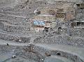
 Naar, like Phu, is a hotchpotch of medieval flat
roofed houses but this time built on a south facing slope rather than over a
hill. It was an amazing sight as I approached it. I found the Shanti Hotel at
the top of the village and checked in to a pokey room above the kitchen.
After a bowl of noodle soup I went for a wander around to take
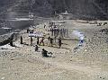
photographs. All around the village on the open flat ground, the villagers
were threshing wheat the old fashioned way with long-handled beaters.
Although the fields are family owned, threshing seemed to be a communal
activity. Each team consisted of 2 opposing lines of 6 men per line, beating the wheat ears laid out
on the ground between them. One line would swing and beat, followed by the
other in rhythmic succession. It was fascinating to watch.
Naar, like Phu, is a hotchpotch of medieval flat
roofed houses but this time built on a south facing slope rather than over a
hill. It was an amazing sight as I approached it. I found the Shanti Hotel at
the top of the village and checked in to a pokey room above the kitchen.
After a bowl of noodle soup I went for a wander around to take
photographs. All around the village on the open flat ground, the villagers
were threshing wheat the old fashioned way with long-handled beaters.
Although the fields are family owned, threshing seemed to be a communal
activity. Each team consisted of 2 opposing lines of 6 men per line, beating the wheat ears laid out
on the ground between them. One line would swing and beat, followed by the
other in rhythmic succession. It was fascinating to watch.
 I returned to the hotel as it got dark and settled
into the kitchen and had daal bhaat and maasu early at 18:30.
After dinner I retired to my room which had now turned into a smokehouse
thanks to the unventilated smoke from the kitchen fire below. I considered
asking for another room but couldn't be bothered to move my stuff so decided
to risk asphyxiation and stay put. I was hoping to be up at dawn and be on
the trail by 6:30 but my mobile phone battery had now completely run out so
I had no alarm to wake me. There was a 20cm square hole cut into the wooden
partition by the door so I hoped that would let in enough light to wake me naturally.
Like Phu, there were no chickens or dogs here that I could see so I wasn't
going to get a wake up call from them. It was 7pm when I climbed in my
sleeping bag. Outside in the freezing dark there was still a team of villagers beating wheat under
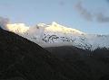
solar-powered flood lights. Unable to sleep, I lay thinking about the day ahead. It had been
very cloudy all afternoon but was clearing now and I hoped it would stay
clear until I crossed the Kang La at least. The Kang La is a high altitude
pass of 5306m according to my map and I was slightly anxious about making
the crossing by myself. I'd spoken to a couple of groups staying in the
village and none were crossing the next day. Altitude sickness was less of a
concern as as I was well acclimatised here at 4110m, but an injury or
navigational blunder could be fatal. I only had a couple of hard boiled
eggs and a few packets of biscuits and nuts for the journey so wasn't equipped long periods
of self-sufficiency. I was hoping to descend as far as Bhraka which would
make it a long day's hike although I wasn't looking forward to joining the
Annapurna circus again. It had been serenely peaceful up in the Naar-Phu
valley and I wished I'd had more time to stick around.
I returned to the hotel as it got dark and settled
into the kitchen and had daal bhaat and maasu early at 18:30.
After dinner I retired to my room which had now turned into a smokehouse
thanks to the unventilated smoke from the kitchen fire below. I considered
asking for another room but couldn't be bothered to move my stuff so decided
to risk asphyxiation and stay put. I was hoping to be up at dawn and be on
the trail by 6:30 but my mobile phone battery had now completely run out so
I had no alarm to wake me. There was a 20cm square hole cut into the wooden
partition by the door so I hoped that would let in enough light to wake me naturally.
Like Phu, there were no chickens or dogs here that I could see so I wasn't
going to get a wake up call from them. It was 7pm when I climbed in my
sleeping bag. Outside in the freezing dark there was still a team of villagers beating wheat under
solar-powered flood lights. Unable to sleep, I lay thinking about the day ahead. It had been
very cloudy all afternoon but was clearing now and I hoped it would stay
clear until I crossed the Kang La at least. The Kang La is a high altitude
pass of 5306m according to my map and I was slightly anxious about making
the crossing by myself. I'd spoken to a couple of groups staying in the
village and none were crossing the next day. Altitude sickness was less of a
concern as as I was well acclimatised here at 4110m, but an injury or
navigational blunder could be fatal. I only had a couple of hard boiled
eggs and a few packets of biscuits and nuts for the journey so wasn't equipped long periods
of self-sufficiency. I was hoping to descend as far as Bhraka which would
make it a long day's hike although I wasn't looking forward to joining the
Annapurna circus again. It had been serenely peaceful up in the Naar-Phu
valley and I wished I'd had more time to stick around.
At about 20:00 the threshing stopped and by 21:00 the activity in the kitchen ceased and the fire put out. After a few hours kip I woke up for the obligatory Diamox piss and then couldn't get back to sleep until after 2:00. At 3:30 the threshing started again taking advantage of the moonlight. I stuck the ear plugs in and dozed until 5:30.
Day 8: Nar - Kang La - Bhraka
| Walking time | 8 hours |
| Sleeping altitude | 3520m |
| Altitude change | -590m |
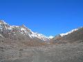 I left the lodge dead on 6:00, descended to the main street through
Naar, turned right (west) and through the village to the big gate. After
another gate and then a row of chortens, the ACAP sign directs you right
onto a path to Kang La. After a short climb to 3 chortens and over
the water tank overflow channel, I joined the single obvious path that
heads west along the right hand side of a moraine ridge. A snow covered
mountain, Chulu Far East (6038m) I think, provides an obvious reference
point to aim for at the valley head.
I left the lodge dead on 6:00, descended to the main street through
Naar, turned right (west) and through the village to the big gate. After
another gate and then a row of chortens, the ACAP sign directs you right
onto a path to Kang La. After a short climb to 3 chortens and over
the water tank overflow channel, I joined the single obvious path that
heads west along the right hand side of a moraine ridge. A snow covered
mountain, Chulu Far East (6038m) I think, provides an obvious reference
point to aim for at the valley head.
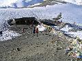
After 1.5 hours the path descended to the valley floor and a further 15 minutes further arrived at Kang La Phedi with a small hut and tiny camping ground. A couple of staff from one of the French groups had already arrived to claim the site leaving no room for the other groups still to come. Why groups stop so soon out of Naar doesn't make sense to me, especially as there is nothing to do here. This would have been way too short a day for my liking. The water pipe was frozen at the campsite and I'd passed no other sources since Naar so I excavated a pit in a dry stream 2 minutes on and filled my water bottles from there. As it turned out this was wasted effort as a little further on there were 2 running streams. Bear Grylls would have been impressed at least!
 At 8:10, I reached the base of the steep slope from where I climbed up a scree path to a cairn in 10 minutes and then contoured around a scree slope
onto moraine to climb gently to a stream in another 35 minutes. This was the
last water source until Nawal, the other side of the Kang La so it's
essential to fill up here. After a 15 minute rest to eat my half hard boiled
egg and some biscuits, I hit the trail again at 9:00. The path crossed the
stream and climbed steeply around the left side of a buttress. After 10
minutes, the path turned left (south) to start the steep climb up the ridge
to the pass. From here the ground was covered in about 30cm of snow although
a path had been trodden through it making the walking slightly less
strenuous.
At 8:10, I reached the base of the steep slope from where I climbed up a scree path to a cairn in 10 minutes and then contoured around a scree slope
onto moraine to climb gently to a stream in another 35 minutes. This was the
last water source until Nawal, the other side of the Kang La so it's
essential to fill up here. After a 15 minute rest to eat my half hard boiled
egg and some biscuits, I hit the trail again at 9:00. The path crossed the
stream and climbed steeply around the left side of a buttress. After 10
minutes, the path turned left (south) to start the steep climb up the ridge
to the pass. From here the ground was covered in about 30cm of snow although
a path had been trodden through it making the walking slightly less
strenuous.
 It was still a hard slog up to the pass with frequent stops
needed to catch my breath. Back to the east, the view of the beautiful peak
of Kang Guru and Manaslu were a welcome distraction from the exertion.
Higher up the path was not exposed but the snow was crusty enough to get a
good grip without being dangerously icy. Without a path or footprints to
follow, it would be difficult to navigate to the pass as it isn't visible
until the last half hour of the climb. After 1 hour and 20 minutes from the
stream (4 hours 20 minutes from Naar), I reached the Kang La.
It was still a hard slog up to the pass with frequent stops
needed to catch my breath. Back to the east, the view of the beautiful peak
of Kang Guru and Manaslu were a welcome distraction from the exertion.
Higher up the path was not exposed but the snow was crusty enough to get a
good grip without being dangerously icy. Without a path or footprints to
follow, it would be difficult to navigate to the pass as it isn't visible
until the last half hour of the climb. After 1 hour and 20 minutes from the
stream (4 hours 20 minutes from Naar), I reached the Kang La.
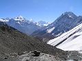
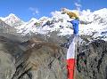
 Despite intermittent clouds, the view over the pass was magnificent with
Annapurna II and IV towering above the forested Marsyangdi river valley
stretched out below. The pass itself is a small notch where the knife-edged
ridge meets a sheer rock wall on the south side. There was just enough room
for the tall chorten and a few cairns that have been built on top of it. It was a
lofty and peaceful place with only the sound of the obligatory Tibetan
prayer flags flapping in the gentle wind to break the silence. I didn't have
any symptoms of altitude sickness at all and I wondered what my "sats"
(blood oxygen saturation) were. Sats is a term my wife, an oncology nurse,
uses which made me think of her and the kids back at home. I spent half an
hour on the pass contemplating life, taking photos and eating the rest of my
food before setting off to rejoin the circus.
Despite intermittent clouds, the view over the pass was magnificent with
Annapurna II and IV towering above the forested Marsyangdi river valley
stretched out below. The pass itself is a small notch where the knife-edged
ridge meets a sheer rock wall on the south side. There was just enough room
for the tall chorten and a few cairns that have been built on top of it. It was a
lofty and peaceful place with only the sound of the obligatory Tibetan
prayer flags flapping in the gentle wind to break the silence. I didn't have
any symptoms of altitude sickness at all and I wondered what my "sats"
(blood oxygen saturation) were. Sats is a term my wife, an oncology nurse,
uses which made me think of her and the kids back at home. I spent half an
hour on the pass contemplating life, taking photos and eating the rest of my
food before setting off to rejoin the circus.
 The slope down the south side of the pass was brutally steep and was
fortunately only snow covered for the first 20m or so. After the snow
though, the descent was down loose scree which could be heard slipping all
around. I didn't hang about and set off at a quick pace. A little further
down, Annapurna III, Gangapurna and Annapurna I came into view in the west
and further down still the full Annapurna range from Lamjung in the east to
Tilicho Peak in the west could be seen. Even Dhaulagiri I was visible at the
western extent of the panorama. It was an awe inspiring view. After 30
minutes of descent, I took the right path where it forked and then right
again after a further 10 minutes to avoid a longer mule trail. Five minutes
further on I left the path to continue on down the crest of a moraine ridge
to avoid the switchbacks. The path dropped off the ridge down a dry river
bed to reach a corrugated steel roofed goTh, 1 hour from the pass.
After another 5 minutes the path descended to a mani wall to rejoin
the main trail. At another fork 25 minutes further on, I went right again to
avoid another longer mule trail which took me down a steep descent past a
line of prayer flags into Nawal. I arrived at about 1pm and stopped for
daal bhaat at the first hotel and filled my water bottles for the first
time in 4 hours.
The slope down the south side of the pass was brutally steep and was
fortunately only snow covered for the first 20m or so. After the snow
though, the descent was down loose scree which could be heard slipping all
around. I didn't hang about and set off at a quick pace. A little further
down, Annapurna III, Gangapurna and Annapurna I came into view in the west
and further down still the full Annapurna range from Lamjung in the east to
Tilicho Peak in the west could be seen. Even Dhaulagiri I was visible at the
western extent of the panorama. It was an awe inspiring view. After 30
minutes of descent, I took the right path where it forked and then right
again after a further 10 minutes to avoid a longer mule trail. Five minutes
further on I left the path to continue on down the crest of a moraine ridge
to avoid the switchbacks. The path dropped off the ridge down a dry river
bed to reach a corrugated steel roofed goTh, 1 hour from the pass.
After another 5 minutes the path descended to a mani wall to rejoin
the main trail. At another fork 25 minutes further on, I went right again to
avoid another longer mule trail which took me down a steep descent past a
line of prayer flags into Nawal. I arrived at about 1pm and stopped for
daal bhaat at the first hotel and filled my water bottles for the first
time in 4 hours.
|
The Upper Manang Trail |
 I set off again at about 13:50 and took the top path out of the village
(instead of the lower tourist route) which descended to a deserted village
(marked Bhardoche on the map) and a large, new-looking gompa built in
2001. The path descended though pine and cypress forest to Julu, a small
traditional agricultural village untainted by the tourist boom. On the trail
I met a red fox which was the only wild mammal I saw on the whole trek.
After crossing the river on a wooden bridge, the path rejoined the main
Ngawal to Bhraka trail, about 1 hour 10 minutes from Ngawal. I stopped at the
Happy Tea Shop for a quick brew and rest, then continued for a final hour to
Bhraka. I stayed at the Ice Lake Hotel which was nice enough and provided a
bucket of hot water for my first full wash in 4 days. I called Govinda to
find out Richard had flown home already so called my friend Raghu in Baglung
to say I'd be staying a few days but found out he was in Kathmandu for the
next 5 days! In the hotel I met 2 Khane Pani technicians who worked with
Yam (my companion on the Phu walk). I took their photo and promised to send them copies which I never did.
I got a lot of requests like this and rather than being honest, I adopted
the Nepali tactic of saying what they wanted to hear and agreeing. Bad
really.
I set off again at about 13:50 and took the top path out of the village
(instead of the lower tourist route) which descended to a deserted village
(marked Bhardoche on the map) and a large, new-looking gompa built in
2001. The path descended though pine and cypress forest to Julu, a small
traditional agricultural village untainted by the tourist boom. On the trail
I met a red fox which was the only wild mammal I saw on the whole trek.
After crossing the river on a wooden bridge, the path rejoined the main
Ngawal to Bhraka trail, about 1 hour 10 minutes from Ngawal. I stopped at the
Happy Tea Shop for a quick brew and rest, then continued for a final hour to
Bhraka. I stayed at the Ice Lake Hotel which was nice enough and provided a
bucket of hot water for my first full wash in 4 days. I called Govinda to
find out Richard had flown home already so called my friend Raghu in Baglung
to say I'd be staying a few days but found out he was in Kathmandu for the
next 5 days! In the hotel I met 2 Khane Pani technicians who worked with
Yam (my companion on the Phu walk). I took their photo and promised to send them copies which I never did.
I got a lot of requests like this and rather than being honest, I adopted
the Nepali tactic of saying what they wanted to hear and agreeing. Bad
really.
Day 9: Bhraka - Thorung High Camp
| Walking time | 5.5 hours |
| Sleeping altitude | 4925m |
| Altitude change | 1405m |
 I woke up at 4am with a churning stomach and took a norfloxacin tablet in
the hope that it would go away. It didn't and eventually got up to visit the
toilet
which turned out not to be as bad as I expected. I finally got up at 6:30
and had cooked museli for breakfast. I hadn't expected it to be cooked and
it was as horrible as you'd imagine it to be. I hit the trail at 8:15 and
soon arrived at Manang town where the path to Tilicho Lake branches off from
the main trail. The original plan before Richard's accident was to spend a
night at the new lodge at Tilicho Base Camp and then another night camping
at the lake before crossing into the Kali Gandaki valley. While I thought it could have been possible to
have crossed from Tilicho Base Camp to Kaisang (first village on the Jomosom
side) in a single long day, it would have been too risky to have done so alone.
I reluctantly listened to common sense and decided I should go over the Thorung La instead.
I woke up at 4am with a churning stomach and took a norfloxacin tablet in
the hope that it would go away. It didn't and eventually got up to visit the
toilet
which turned out not to be as bad as I expected. I finally got up at 6:30
and had cooked museli for breakfast. I hadn't expected it to be cooked and
it was as horrible as you'd imagine it to be. I hit the trail at 8:15 and
soon arrived at Manang town where the path to Tilicho Lake branches off from
the main trail. The original plan before Richard's accident was to spend a
night at the new lodge at Tilicho Base Camp and then another night camping
at the lake before crossing into the Kali Gandaki valley. While I thought it could have been possible to
have crossed from Tilicho Base Camp to Kaisang (first village on the Jomosom
side) in a single long day, it would have been too risky to have done so alone.
I reluctantly listened to common sense and decided I should go over the Thorung La instead.
 I reached Ledar in a speedy 3¼ hours where I stopped
for egg noodle soup before getting back on the trail at midday. After 1 hour
40 minutes of fast trekking I reached Thorung Phedi to find that all
the lodges were full. I was kind of glad as it was a soulless place full of
bored looking trekkers milling around killing time before their pre-dawn pass
crossing. After a brief rest to talk to some of the guides I'd meet in the
first few days of the trek, I continued on to Thorung High Camp which at
4925m was another 475m higher than Thorung Phedi and only 491m from the
pass. It took only 35 minutes to climb the 475m and I thought about
continuing on over the pass but I was too tired and it looked like a nice
teahouse for it's extreme location. I took a twin room for Rs 280 rather
than risk the dormitory and after dumping my rucksack, went for a wander up
a small peak to take some photos.
I reached Ledar in a speedy 3¼ hours where I stopped
for egg noodle soup before getting back on the trail at midday. After 1 hour
40 minutes of fast trekking I reached Thorung Phedi to find that all
the lodges were full. I was kind of glad as it was a soulless place full of
bored looking trekkers milling around killing time before their pre-dawn pass
crossing. After a brief rest to talk to some of the guides I'd meet in the
first few days of the trek, I continued on to Thorung High Camp which at
4925m was another 475m higher than Thorung Phedi and only 491m from the
pass. It took only 35 minutes to climb the 475m and I thought about
continuing on over the pass but I was too tired and it looked like a nice
teahouse for it's extreme location. I took a twin room for Rs 280 rather
than risk the dormitory and after dumping my rucksack, went for a wander up
a small peak to take some photos.
 I returned to the lodge restaurant feeling pretty ropey with an altitude
headache so took some diamox and ibuprofen. I started thinking about the day
ahead and decided that I would cancel the flight from Jomosom to Pokhara,
which wasn't due to depart for several more days, and would instead do the 2
day jeep and walk combination down the Kali Gandaki to get to Baglung. I
wasn't really enjoying being back on the Annapurna circuit again after my
few days of solitude in the Naar-Phu valley. It was a pity I hadn't known
about Richard's departure sooner as I could have stayed there longer but now
that I was out I wanted to get to Baglung as quickly as possible to be with
Raghu in time for the Tihar (Diwali) festival. I felt pretty low and was
missing Suzie and the girls terribly so decided to be sociable to take my
mind off it. I joined a group of French trekkers and a Polish English
teacher for a chat and to warm my feet on the under-table electric heater
while I waited for my dinner to arrive. I arranged for a 5am wake up call
from the Pole so I could be on the trail by 6am at the latest.
I returned to the lodge restaurant feeling pretty ropey with an altitude
headache so took some diamox and ibuprofen. I started thinking about the day
ahead and decided that I would cancel the flight from Jomosom to Pokhara,
which wasn't due to depart for several more days, and would instead do the 2
day jeep and walk combination down the Kali Gandaki to get to Baglung. I
wasn't really enjoying being back on the Annapurna circuit again after my
few days of solitude in the Naar-Phu valley. It was a pity I hadn't known
about Richard's departure sooner as I could have stayed there longer but now
that I was out I wanted to get to Baglung as quickly as possible to be with
Raghu in time for the Tihar (Diwali) festival. I felt pretty low and was
missing Suzie and the girls terribly so decided to be sociable to take my
mind off it. I joined a group of French trekkers and a Polish English
teacher for a chat and to warm my feet on the under-table electric heater
while I waited for my dinner to arrive. I arranged for a 5am wake up call
from the Pole so I could be on the trail by 6am at the latest.
After a very tasty egg & vegetable fried rice, I retired to my room at 19:45. It was freezing by now so slipped into my thermal leggings, 2 fleece tops, hat, gloves and socks and snuggled into my 4 season down sleeping bag. I was glad I had made the effort to come up here rather than sleep on a floor in grotty Phedi. At over 4900m, it's a cold desolate place to build a lodge but it's well constructed and very well managed.
Day 10: Thorung High Camp - Thorung La - Muktinath - Beni
| Total travel time | 12.5 hours |
| Walking time | 5 hours |
| Sleeping altitude | 830m |
| Altitude change | -4095m |
I slept fine until midnight and then woke up with a headache and urgent need to piss. After a quick foray into the snowy night, I struggled to get back to sleep and drifted in an out of altitude dream weirdness until about 4:00 when the first groups started to trudge past the window on their way to the pass. Why anyone lets their guide persuade them to trek up to the pass in the freezing darkness is a mystery to me. There's nothing to see on the way up except the small illuminated circle of ground in front of you and when you get there, the light will be too poor to take any decent photos. Furthermore, it really isn't that great a view from the Thorung La and certainly not worth sacrificing sleep and breakfast for. My advice is to stay in bed and save your head torch batteries.
 I left the lodge at 6:05 after a breakfast of pancake and black tea. My
total bill was 880 Rs which was pretty steep for me but this was the
remotest lodge on the circus I guess. I started off quickly and soon burned
past the straggling groups feeling smug that I'd had an extra hour in bed
and a warm breakfast. It was breathless work so I slowed to a more steady
pace but still reached the pass by 7:40, 95 minutes from High Camp. The sun
had risen over the surrounding hills by the time I'd arrived which made the
place seem a bit more welcoming but the crowds of trekkers, a teashop and a
tacky signboard congratulating us for the (sic) success trashed any possible
ambience. Perhaps I'm a mountain snob or was just spoiled by the quality of
the peaks earlier in the trek, but the view over the pass into the Kali Gandaki valley isn't much to get excited about either. The only mountain of
note, Dhaulagiri I, isn't visible until you've descended a few minutes and
even then it's the less impressive north face you see from here.
I left the lodge at 6:05 after a breakfast of pancake and black tea. My
total bill was 880 Rs which was pretty steep for me but this was the
remotest lodge on the circus I guess. I started off quickly and soon burned
past the straggling groups feeling smug that I'd had an extra hour in bed
and a warm breakfast. It was breathless work so I slowed to a more steady
pace but still reached the pass by 7:40, 95 minutes from High Camp. The sun
had risen over the surrounding hills by the time I'd arrived which made the
place seem a bit more welcoming but the crowds of trekkers, a teashop and a
tacky signboard congratulating us for the (sic) success trashed any possible
ambience. Perhaps I'm a mountain snob or was just spoiled by the quality of
the peaks earlier in the trek, but the view over the pass into the Kali Gandaki valley isn't much to get excited about either. The only mountain of
note, Dhaulagiri I, isn't visible until you've descended a few minutes and
even then it's the less impressive north face you see from here.
 After a 10 minute snack break away from the madding crowds, I descended
the moraine slope to the tea shops at it's terminus in 1 hour 35 minutes.
The first hour wasn't too strenuous but after that the slope became knee
achingly steep. From the teashops, it was a further 45 minutes of more
gentle descent to reach Muktinath. I never recalled Muktinath as being a picturesque place from my previous
visits in 1995 and
2001 but I wasn't prepared
for it to be as grim as it was now. A hideous concrete gate had been built
to greet visitors' arrival from the Thorung La trail and an even more ugly
concrete wall topped with barbed wire had been built around the sacred site.
A load of new concrete houses had cropped up too. The arrival of the
motorable road had clearly not benefited the local environment. Eager to
move on, I headed straight for the jeep park at the far end of town to catch
a pricy 500 Rs ride to Jomosom (yes I am a hypocrite, I know). Unfortunately
the next jeep was a long way from being full so I ordered daal bhaat
to kill some time. Over an hour later, the jeep was crammed with12 of us
inside and 1 on the roof with the bags, and at 12:15, it finally rolled out
of town.
After a 10 minute snack break away from the madding crowds, I descended
the moraine slope to the tea shops at it's terminus in 1 hour 35 minutes.
The first hour wasn't too strenuous but after that the slope became knee
achingly steep. From the teashops, it was a further 45 minutes of more
gentle descent to reach Muktinath. I never recalled Muktinath as being a picturesque place from my previous
visits in 1995 and
2001 but I wasn't prepared
for it to be as grim as it was now. A hideous concrete gate had been built
to greet visitors' arrival from the Thorung La trail and an even more ugly
concrete wall topped with barbed wire had been built around the sacred site.
A load of new concrete houses had cropped up too. The arrival of the
motorable road had clearly not benefited the local environment. Eager to
move on, I headed straight for the jeep park at the far end of town to catch
a pricy 500 Rs ride to Jomosom (yes I am a hypocrite, I know). Unfortunately
the next jeep was a long way from being full so I ordered daal bhaat
to kill some time. Over an hour later, the jeep was crammed with12 of us
inside and 1 on the roof with the bags, and at 12:15, it finally rolled out
of town.
 We were making good progress initially and I even allowed myself to
hope that I might get to Baglung that same day. Then a puncture hit, and of
course we didn't have a spare wheel so had to wait for the another jeep to
come along that did have one of the same size. Surprisingly we didn't have
to wait long and after a quick change, were back on the trail and in Jomosom
by 13:45. Much of the jeep track is built over the trekking trail so that
poor trekkers trying to enjoy their tranquil Himalayan hiking holiday get
plunged into clouds of dust each time a vehicle goes by. Horrible.
We were making good progress initially and I even allowed myself to
hope that I might get to Baglung that same day. Then a puncture hit, and of
course we didn't have a spare wheel so had to wait for the another jeep to
come along that did have one of the same size. Surprisingly we didn't have
to wait long and after a quick change, were back on the trail and in Jomosom
by 13:45. Much of the jeep track is built over the trekking trail so that
poor trekkers trying to enjoy their tranquil Himalayan hiking holiday get
plunged into clouds of dust each time a vehicle goes by. Horrible.
To catch the next jeep as far as Ghasa, I had to walk through Jomoson to the jeep park on the south side of town. While it was an inconvenience to have to walk this half mile, it certainly benefited the town environment by keeping it free of the dust clouds and fumes. Despite the high cost (600 Rs this time), the jeep filled up quickly and we were on our way by 14:15 and in Ghasa by 16:55. Again, much of the track had doubled as the trekking trail and had made a hellish mess of what was once a beautiful trekking route. There were some sections still unspoiled, most notably through Marpha and the trail from Kobang to Kalopani. Still, I was glad I'd walked this trail before the march of progress had ruined it once and for all.
 I debated whether to stay the night in Ghasa but was persuaded by some
Kathmandu students I'd teamed up with to press on. A landslide below Ghasa
had taken out the road so we had to walk for 40 minutes to the next road
head at Kabre. After a half hour wait for a jeep that was never going to
come, we walked on in twilight to the next village of Titar where a small
bus was about to leave. It was rammed so I sat on the roof dodging low
branches and fireflies for the first hour until my backside could take the
bumps no more. Fortunately, the number of passengers inside the bus had
thinned out and I had a seat for the remaining 2¼ hours
to Beni. Even in the dark I could tell the road was in poor condition, which
was frequently evidenced by the sideways sliding and wheel spinning of the
struggling bus. It was just as well I couldn't see where the precipices
were.
I debated whether to stay the night in Ghasa but was persuaded by some
Kathmandu students I'd teamed up with to press on. A landslide below Ghasa
had taken out the road so we had to walk for 40 minutes to the next road
head at Kabre. After a half hour wait for a jeep that was never going to
come, we walked on in twilight to the next village of Titar where a small
bus was about to leave. It was rammed so I sat on the roof dodging low
branches and fireflies for the first hour until my backside could take the
bumps no more. Fortunately, the number of passengers inside the bus had
thinned out and I had a seat for the remaining 2¼ hours
to Beni. Even in the dark I could tell the road was in poor condition, which
was frequently evidenced by the sideways sliding and wheel spinning of the
struggling bus. It was just as well I couldn't see where the precipices
were.
It was 21:30 when the bus finally revved it's way into a very closed up Beni. After no response from the first hotel, the second was more accommodating and took everyone left on the bus in. Of course they didn't have enough rooms for everyone so I ended up sharing a triple room with the 4 students. I was so shattered I could I gone to bed there and then but had to wait until 23:30 for the daal bhaat to arrive. Luckily the students shared the double bed leaving the single for me. It was a bad night though and I'd wished I'd stayed in Ghasa after all. Still, it had been an epic day and I was only 2 hours from Baglung where I now had 5 days to hang out with old friends.
© Steven Flower 2012
