|
Location:
|

|
Western Region, 100km North-West of Pokhara.
|
|
Route:
|
|
Pokhara - Jomosom - Muktinath - Beni -
Pokhara
|
|
Map:
|
|
"Round Annapurna", Mandala Trekking Maps.
|
|
Season:
|
|
October - April
|
|
Days:
|
|
9-10
|
|
Equipment:
|
|
3 season sleeping bag & cold
weather clothes.
|
|
Permits
|
|
ACAP national park permit.
|
 The
Jomosom or Mukhtinath trek is the most popular and well developed in Nepal. Its popularity is, however, well deserved since
it is able to offer so much scenic and cultural diversity within such a short
distance (relatively speaking). Close proximity to Pokhara, low altitude and
an easy trail make it accessible to trekkers of all ages and
abilities and it can be undertaken as a trek in its own right or as part of
the epic Annapurna circuit or Dhaulagiri
base camp treks. Many trekkers combine it with a trek to Poon Hill and
even to the Annapurna sanctuary. The trek starts and ends at Pokhara and usually involves
a flight in one direction or another - it doesn't really matter which
although walking in and flying out does avoid the sudden gain in altitude. At the other end is a short bus journey from Beni or Naya Pul
depending on whether you add Poon Hill to your itinerary. The
Jomosom or Mukhtinath trek is the most popular and well developed in Nepal. Its popularity is, however, well deserved since
it is able to offer so much scenic and cultural diversity within such a short
distance (relatively speaking). Close proximity to Pokhara, low altitude and
an easy trail make it accessible to trekkers of all ages and
abilities and it can be undertaken as a trek in its own right or as part of
the epic Annapurna circuit or Dhaulagiri
base camp treks. Many trekkers combine it with a trek to Poon Hill and
even to the Annapurna sanctuary. The trek starts and ends at Pokhara and usually involves
a flight in one direction or another - it doesn't really matter which
although walking in and flying out does avoid the sudden gain in altitude. At the other end is a short bus journey from Beni or Naya Pul
depending on whether you add Poon Hill to your itinerary.
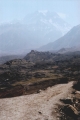
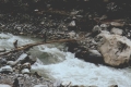
 The
trail follows the mighty Kali Gandaki river, known locally by the
indigenous Thakali people as the "Thak Khola". The river has its source inside Tibet and cuts a deep gorge between the Annapurna and Dhaulagiri
massifs on its way to join the Ganges in India. The geographical
transition on the trek is dramatic with sub-tropical forest and rice paddy on
the lower section giving way to conifers and fruit cultivation
further up and ending in a mountain rain-shadow desert dotted with oases of irrigated
settlement at the top. The ethnic and cultural transition is also marked with
the Hindu Brahmin, Chhetri and Magar groups dominating in the lower
reaches of the river
and the Buddhist Thakali ethnic group dominating further up.
It is this combination of dramatic scenery and diverse culture that makes
the Jomosom trek so fascinating and enjoyable. The
trail follows the mighty Kali Gandaki river, known locally by the
indigenous Thakali people as the "Thak Khola". The river has its source inside Tibet and cuts a deep gorge between the Annapurna and Dhaulagiri
massifs on its way to join the Ganges in India. The geographical
transition on the trek is dramatic with sub-tropical forest and rice paddy on
the lower section giving way to conifers and fruit cultivation
further up and ending in a mountain rain-shadow desert dotted with oases of irrigated
settlement at the top. The ethnic and cultural transition is also marked with
the Hindu Brahmin, Chhetri and Magar groups dominating in the lower
reaches of the river
and the Buddhist Thakali ethnic group dominating further up.
It is this combination of dramatic scenery and diverse culture that makes
the Jomosom trek so fascinating and enjoyable.
 I first trekked this route in 1995 as part of the Dhaulagiri
base camp trek but wasn't able to fully appreciate the wonderful
diversity it had to offer because I rushed through to reach base camp. I later returned in April 2001 with my wife, Suzie, and spent 9 days
trekking to many of the old places but also to some new ones, including
the Dhaulagiri icefall. On my revisit, I noticed many
new developments along the trail but much of the old charm still remained.
Be warned though, the road from Beni is advancing all the time so I recommend
anyone considering doing this trek to do so soon, before it becomes nothing more than a bus ride. I first trekked this route in 1995 as part of the Dhaulagiri
base camp trek but wasn't able to fully appreciate the wonderful
diversity it had to offer because I rushed through to reach base camp. I later returned in April 2001 with my wife, Suzie, and spent 9 days
trekking to many of the old places but also to some new ones, including
the Dhaulagiri icefall. On my revisit, I noticed many
new developments along the trail but much of the old charm still remained.
Be warned though, the road from Beni is advancing all the time so I recommend
anyone considering doing this trek to do so soon, before it becomes nothing more than a bus ride.
 Road
Construction: 2011
Update Road
Construction: 2011
Update
At the time of trekking in 2001, the road had reached as far as Galashwor, about 5km north of Beni.
Then the buses from Pokhara and Kathmandu terminated on the opposite
side of the Kali Gandaki from Beni and trekkers had to cross on the
foot bridge and catch a taxi or jeep from the bazaar. Now a road
bridge has been built across the river and the unpaved road has been
extended all the way to Jomosom
and beyond. When I last travelled this route in 2011, you could take a jeep or bus
from Beni for 3 hours as
far as Kabre from where you had to walk for 40 minutes around some
landslides as far as Ghasa where the road started again. From Ghasa
a jeep was available all the way to Jomosom (2.5 hours) and beyond.
I suspect now the landslides have been cleared and the road is again
open all the way. Much of the jeep track is built over the trekking
trail enveloping trekkers under clouds of dust each time a vehicle
goes by. There were some sections still unspoiled, most notably
through Marpha and the trail from Kobang to Kalopani but inevitably, much of
the charm of this trail has been lost. |
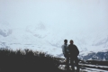
Day 1. Pokhara - Jomosom
- Kagbeni
 Our
decision to fly in to Jomosom, rather than out, gave us more control over
the duration of the trek as it eliminated the uncertainty of potential
flight delays on exit. Travelling in this direction does, however,
increase the risk of suffering from symptoms of acute mountain sickness (AMS) from the
sudden vertical gain of over 2000m. Getting AMS at this low altitude is unlikely and can be successfully avoided by
taking a course of diamox (see the High
Altitude Medicine Guide for more info). There were 2 private operators
offering flights on 19 seater Twin Otter planes to Jomosom: Gorkha Airlines &
Cosmic Air. Both were running 4 flights a day during the trekking season
with hourly departures starting at 5:30am and lasting 25 minutes. Tickets cost about $60 depending on the booking agent.
State owned RNAC also operate flights in this sector. The early
start, which avoids landing in the high wind that picks up during late morning, does give you a full day to make a start on the trek. This is
just as well as Jomosom, Mustang district's headquarter town, is not the
most idyllic
place to stay. Our
decision to fly in to Jomosom, rather than out, gave us more control over
the duration of the trek as it eliminated the uncertainty of potential
flight delays on exit. Travelling in this direction does, however,
increase the risk of suffering from symptoms of acute mountain sickness (AMS) from the
sudden vertical gain of over 2000m. Getting AMS at this low altitude is unlikely and can be successfully avoided by
taking a course of diamox (see the High
Altitude Medicine Guide for more info). There were 2 private operators
offering flights on 19 seater Twin Otter planes to Jomosom: Gorkha Airlines &
Cosmic Air. Both were running 4 flights a day during the trekking season
with hourly departures starting at 5:30am and lasting 25 minutes. Tickets cost about $60 depending on the booking agent.
State owned RNAC also operate flights in this sector. The early
start, which avoids landing in the high wind that picks up during late morning, does give you a full day to make a start on the trek. This is
just as well as Jomosom, Mustang district's headquarter town, is not the
most idyllic
place to stay.
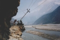
 Kagbeni,
a 2 hour walk up the Thak Khola from Jomosom, is a charming medieval
fortress village on the edge of the Tibetan plateau and the boundary of
the restricted upper Mustang region. The village is a hotchpotch of
habited and derelict houses with narrow alleyways leading into hidden
courtyards and stables. The main trail dissects the village and it is
along here where you will find the hotels, shops and a Buddhist gompa. We
stayed in the Red House Lodge which I had stayed at 6 years before. It is
a comfortable, friendly place which, apart from a new extension, had
changed little since my first trip. The gompa and the ACAP museum
displaying photographs and artefacts from upper Mustang are interesting
attractions here. Kagbeni,
a 2 hour walk up the Thak Khola from Jomosom, is a charming medieval
fortress village on the edge of the Tibetan plateau and the boundary of
the restricted upper Mustang region. The village is a hotchpotch of
habited and derelict houses with narrow alleyways leading into hidden
courtyards and stables. The main trail dissects the village and it is
along here where you will find the hotels, shops and a Buddhist gompa. We
stayed in the Red House Lodge which I had stayed at 6 years before. It is
a comfortable, friendly place which, apart from a new extension, had
changed little since my first trip. The gompa and the ACAP museum
displaying photographs and artefacts from upper Mustang are interesting
attractions here.
Day 2. Kagbeni - Mukhtinath - Jharkot
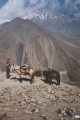 At
an altitude of 3800m, Mukhtinath is 900m above Kagbeni which can make this quite a tiring
climb unless you cheat and hire ponies to do the work for you. We hired
ponies from the lodge for 500 rupees each which was the same price as 6
years earlier although at that time I was a trekking purist and had refused 4
legged assistance. This time though, there was an additional 300 rupees for an accompanying
horseman and you're expected to pay for his daal bhaat and tea.
Despite the expense, this is an excellent, although sore, experience and a
good way to take in the scenery without having to worry about kicking at
rocks. Keeping the nags from jostling each other off the trail is
a major effort, however! At
an altitude of 3800m, Mukhtinath is 900m above Kagbeni which can make this quite a tiring
climb unless you cheat and hire ponies to do the work for you. We hired
ponies from the lodge for 500 rupees each which was the same price as 6
years earlier although at that time I was a trekking purist and had refused 4
legged assistance. This time though, there was an additional 300 rupees for an accompanying
horseman and you're expected to pay for his daal bhaat and tea.
Despite the expense, this is an excellent, although sore, experience and a
good way to take in the scenery without having to worry about kicking at
rocks. Keeping the nags from jostling each other off the trail is
a major effort, however!
 Mukhtinath
is a top pilgrimage site for Hindus and there are both Hindu and Buddhist
temples on the site of an eternal natural gas flame. The temples are a short distance above the village, a not so charming string of lodges
straight from the set of a Hollywood Western. Mukhtinath tends to get busy
late in the day with Annapurna circuit trekkers coming down from the
Thorung La pass. To avoid this, we returned to Jharkot,
half an hour's walk back down the Kagbeni trail, and stayed at the Sonam which
was one of my favourite lodges on the previous trip. Jharkot is a
traditional hilltop fortress with a lovely old gompa at its furthest end
and panoramic views across the Himalaya. Word must have spread
though, as the lodges here had filled up by the afternoon - just as well I
reserved our room on the way up! Mukhtinath
is a top pilgrimage site for Hindus and there are both Hindu and Buddhist
temples on the site of an eternal natural gas flame. The temples are a short distance above the village, a not so charming string of lodges
straight from the set of a Hollywood Western. Mukhtinath tends to get busy
late in the day with Annapurna circuit trekkers coming down from the
Thorung La pass. To avoid this, we returned to Jharkot,
half an hour's walk back down the Kagbeni trail, and stayed at the Sonam which
was one of my favourite lodges on the previous trip. Jharkot is a
traditional hilltop fortress with a lovely old gompa at its furthest end
and panoramic views across the Himalaya. Word must have spread
though, as the lodges here had filled up by the afternoon - just as well I
reserved our room on the way up!
Day 3. Jharkot - Marpha
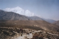 This
is a long walk for a single day and the less ambitious might chose to stay
in Jomosom or Syang. The trails starts as for Kagbeni and then forks off
to the south (left) after half an hour for Eklebhatti. The views down the
Thak Khola to Nilgiri and Dhaulagiri are magnificent along this stretch of
the trail. Eklebhatti is a good
place to stop for tea but a wee bit early for daal bhaat, even for
me. Jomosom is ideally placed for this and is a handy place to rest from the
fierce Thak Khola wind that whips up around this time of day. After
Jomosom, its a further 2-3 hour walk against the wind to Marpha. This
is a long walk for a single day and the less ambitious might chose to stay
in Jomosom or Syang. The trails starts as for Kagbeni and then forks off
to the south (left) after half an hour for Eklebhatti. The views down the
Thak Khola to Nilgiri and Dhaulagiri are magnificent along this stretch of
the trail. Eklebhatti is a good
place to stop for tea but a wee bit early for daal bhaat, even for
me. Jomosom is ideally placed for this and is a handy place to rest from the
fierce Thak Khola wind that whips up around this time of day. After
Jomosom, its a further 2-3 hour walk against the wind to Marpha.
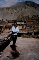
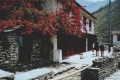
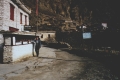 Marpha
is
another picturesque traditional Thakali village although more developed
than Kagbeni and Jharkot. It's also more touristy with an excessive number
of shops and street traders selling trinkets and fake antiques. On the
plus side, there's plenty of lodges in Marpha so accommodation is rarely a
problem. We stayed at the Dhaulagiri Guest House which has simple rooms
built around a small courtyard and has a solar-heated shower. Marpha
is
another picturesque traditional Thakali village although more developed
than Kagbeni and Jharkot. It's also more touristy with an excessive number
of shops and street traders selling trinkets and fake antiques. On the
plus side, there's plenty of lodges in Marpha so accommodation is rarely a
problem. We stayed at the Dhaulagiri Guest House which has simple rooms
built around a small courtyard and has a solar-heated shower.
Day 4. Marpha - Larjung
 From
Marpha, the
trail continues along the right bank of the Thak Khola to Tukuche, a
beautiful village surrounded by fruit orchards and terraced fields.
There's a distillery here which is an interesting attraction if open (it
wasn't for us on this occasion). Tukuche would be an ideal place to stay if
staying at Jomosom or Syang the previous night. For Marpha stoppers, its a
convenient lunching stop. After Tukuche, the Thak Khola meanders
in braided channels down the broadened valley bottom and the scrub
vegetation gives way to progressively denser forest as the descent
continues. From
Marpha, the
trail continues along the right bank of the Thak Khola to Tukuche, a
beautiful village surrounded by fruit orchards and terraced fields.
There's a distillery here which is an interesting attraction if open (it
wasn't for us on this occasion). Tukuche would be an ideal place to stay if
staying at Jomosom or Syang the previous night. For Marpha stoppers, its a
convenient lunching stop. After Tukuche, the Thak Khola meanders
in braided channels down the broadened valley bottom and the scrub
vegetation gives way to progressively denser forest as the descent
continues.
 Larjung
is only a couple of hours from Tukche which means you can spend the
afternoon drinking tea, washing socks, sleeping and showering while
there's still hot water. We stayed in the Larjung Lodge which is the
southernmost in the village run by a friendly Thakali didi. The
village itself is small and without tourist attractions but is quaint and
peaceful as a result. Most trekkers seem to hike onto Kalopani so it
doesn't get crowded here. Larjung is also the best place to use as a base
for a hike to the Dhaulagiri icefall. Larjung
is only a couple of hours from Tukche which means you can spend the
afternoon drinking tea, washing socks, sleeping and showering while
there's still hot water. We stayed in the Larjung Lodge which is the
southernmost in the village run by a friendly Thakali didi. The
village itself is small and without tourist attractions but is quaint and
peaceful as a result. Most trekkers seem to hike onto Kalopani so it
doesn't get crowded here. Larjung is also the best place to use as a base
for a hike to the Dhaulagiri icefall.
Day 5. The
Dhaulagiri Icefall
 Dhaulagiri
icefall is the glacier on the south slope beneath the northeast col
between the peaks of Dhaulagiri I and Tukuche. A return trip from Larjung is an
energetic but rewarding 9 hour hike so an early start is essential. There
are no settlements on the trail so we had the didi make up a
packed lunch of Tibetan bread and hard boiled eggs the night before.
Despite the unsettled weather, we set off at 6am along the main trail
south accompanied by the hotel boy who had come to point us in the right direction.
He was heading to the fields to work for the day. Dhaulagiri
icefall is the glacier on the south slope beneath the northeast col
between the peaks of Dhaulagiri I and Tukuche. A return trip from Larjung is an
energetic but rewarding 9 hour hike so an early start is essential. There
are no settlements on the trail so we had the didi make up a
packed lunch of Tibetan bread and hard boiled eggs the night before.
Despite the unsettled weather, we set off at 6am along the main trail
south accompanied by the hotel boy who had come to point us in the right direction.
He was heading to the fields to work for the day.
 The trail to the icefall
starts after crossing the first tributary and climbs up through forest and
onto yak pasture. There were campsites here where trekking parties had
pitched in order to give themselves a head start on the ascent.
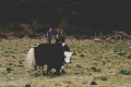
Further on there were yak herders' camps and grazing yaks with calves. The
herders wanted us to stop for tea but we declined for fear of the weather
worsening. Beyond the last of the forest, the climb became steeper and
harder as the gain in altitude became more apparent. This upper pasture
was covered in tiny purple and white orchids which provided a brief
distraction from the slog. After a traverse and a final steep climb up a
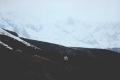
grassy gully, the path emerged onto an upper terrace. From here the peaks
of Dhaulagiri I and Tukuche would have been clearly visible on a good day
but for us only the lower icefall and surrounding snowy ridges could be
seen through the low cloud. We hiked a little further towards the base of
the icefall but the slushy snow underfoot soaked through our canvas boots
and forced us to stop a kilometer short. After watching a massive
avalanche further round the basin, we weren't too sorry to be turning
back early! The return trip was a hasty one as the rain had started and we
were back in the lodge by 3pm for tea and chow chow (noodles) and a much needed shower. The trail to the icefall
starts after crossing the first tributary and climbs up through forest and
onto yak pasture. There were campsites here where trekking parties had
pitched in order to give themselves a head start on the ascent.
Further on there were yak herders' camps and grazing yaks with calves. The
herders wanted us to stop for tea but we declined for fear of the weather
worsening. Beyond the last of the forest, the climb became steeper and
harder as the gain in altitude became more apparent. This upper pasture
was covered in tiny purple and white orchids which provided a brief
distraction from the slog. After a traverse and a final steep climb up a
grassy gully, the path emerged onto an upper terrace. From here the peaks
of Dhaulagiri I and Tukuche would have been clearly visible on a good day
but for us only the lower icefall and surrounding snowy ridges could be
seen through the low cloud. We hiked a little further towards the base of
the icefall but the slushy snow underfoot soaked through our canvas boots
and forced us to stop a kilometer short. After watching a massive
avalanche further round the basin, we weren't too sorry to be turning
back early! The return trip was a hasty one as the rain had started and we
were back in the lodge by 3pm for tea and chow chow (noodles) and a much needed shower.
Alternative
Route
On our return, we met a trekking party at the campsite who told us of a more direct route to the
icefall that their guide had just taken them up. We had taken the
conventional route as described in Bryn Thomas' "Trekking in the Annapurna Region" guide book which wasn't very direct but was easy to
find and was safe. Unless you have a guide who knows this direct route, I
wouldn't recommend looking for it as it would be very easy to get lost
around here and find yourself on dangerously steep ground. |
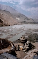
Day 6. Larjung - Ghasa
 Larjung to Ghasa is the last day of what I would call Himalayan
trekking. It is a 5 hour downhill hike (excluding stops) through densely forested landscape
and only partial mountain views. The Thak Khola valley is narrower and steeper
from Larjung and the reiver's flow is more rapid and powerful. The trail takes you
through the joined villages of Kalopani and Lete which are convenient for
a lunch stop. Both are also popular overnight stays and there are plenty
of hotels to chose from. Lete even has a college for training hoteliers
and chefs. Ghasa is an hour of steep descending from Lete and right on cue as we
arrived, the heavens opened. We dived into the first hotel which happened
to be the Florida Lodge. The rain didn't stop until after dark so we
stayed put. Larjung to Ghasa is the last day of what I would call Himalayan
trekking. It is a 5 hour downhill hike (excluding stops) through densely forested landscape
and only partial mountain views. The Thak Khola valley is narrower and steeper
from Larjung and the reiver's flow is more rapid and powerful. The trail takes you
through the joined villages of Kalopani and Lete which are convenient for
a lunch stop. Both are also popular overnight stays and there are plenty
of hotels to chose from. Lete even has a college for training hoteliers
and chefs. Ghasa is an hour of steep descending from Lete and right on cue as we
arrived, the heavens opened. We dived into the first hotel which happened
to be the Florida Lodge. The rain didn't stop until after dark so we
stayed put.
Day 7. Ghasa - Tatopani
 The
trail descends 800 vertical metres to Tatopani in just over 10km giving an
average gradient of 1 in 13. In places it is much steeper where the
swollen Thak Khola cuts into the softer sediment. Accompanying the loss in
altitude is the higher temperature which makes this an uncomfortably hot
day's trekking. The village of Dana is a handy halfway rest stop where we
had a great daal bhaat served with prawn crackers. On reaching Tatopani,
there's the obligatory visit to the volcanically heated baths to soak away
the day's aches and pains. The baths are the only reason to stay here as
Tatopani is the Thak Khola's equivalent of Katmandu's Thamel. It rained heavily again
which was a surreal experience as it splashed around me in the hot baths. The
trail descends 800 vertical metres to Tatopani in just over 10km giving an
average gradient of 1 in 13. In places it is much steeper where the
swollen Thak Khola cuts into the softer sediment. Accompanying the loss in
altitude is the higher temperature which makes this an uncomfortably hot
day's trekking. The village of Dana is a handy halfway rest stop where we
had a great daal bhaat served with prawn crackers. On reaching Tatopani,
there's the obligatory visit to the volcanically heated baths to soak away
the day's aches and pains. The baths are the only reason to stay here as
Tatopani is the Thak Khola's equivalent of Katmandu's Thamel. It rained heavily again
which was a surreal experience as it splashed around me in the hot baths.
Day
8. Tatopani - Galashawor
It was a relief to leave Tatopani and
part company with the masses, most of whom were headed across the river
and up to Gorepani and Poon Hill. That said, the Gorepani trek is probably
a more interesting, although strenuous, addition to the Jomosom Trek and
essential if heading to Annapurna Base Camp. For us though, time
constraints, poor weather and engagements in Baglung, meant exiting via
Beni instead. The trek itself was long, hot and uninspiring but Galashawor
(also known as Raghughat) was a charming bazaar village overlooking the
Thak Khola and Raghughat Khola confluence. We stayed in Hotel Riverside
which was a peaceful and friendly lodge with a beautiful Bougainvillea
plant growing over the garden. Sadly the rain started up before I could
take any photographs! Day 9.
Galashawor - Baglung
At the time of visiting in 2001, Galashawor
was the new road head on the extension from Baglung which meant the lower
bazaar had turned into a jeep and taxi terminus for shared rides to Beni. You can privately hire taxis all the way to Pokhara from here
but the prices are high. On a shared jeep, it cost 30 rupees to Beni and
then 50 rupees on another jeep to Baglung. For Pokhara buses, Beni is the
closest terminus but for Kathmandu and Chitawan, Baglung was more reliable.
|