
| Home | Credits | Woodland | History | The Year Round | Species | Bibliography | Maps |
Exploring Worcester Woods: the Country Park
Nick Cripps

| Home | Credits | Woodland | History | The Year Round | Species | Bibliography | Maps |
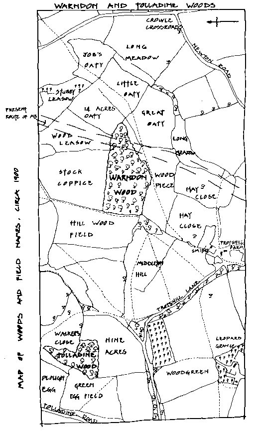
Because nobody officially lived inside them, small local woodlands and coppices tend to be poorly documented. The Doomsday Book in 1086, makes a reference to Warndon. It mentions a wood, two furlongs by one furlong wide, presumably our present day Warndon Wood. The land was known to be held by Urso of Abetot, the then Sheriff of Worcester.
Around 1780 the Warndon Parish of 'Trotswell, Smyte and Tollerdine’ supported only ten families, with farming their main livelihood. Citizens of the City of Worcester who owned livestock often held leases to graze their cattle in the Warndon area. The indigenous stiff keuper marl of the parish made for natural pasture land. The unyielding clay earned the area the nick name 'Horse killing land', so hard and so punishing the task of ploughing through it.
Two prominent architectural features of the parish are St. Nicholas Church and the adjacent Manor House. The award winning restoration of the 900-year-old Norman Church was completed in 1992. Its 16th century half-timbered, tower has been rendered using cow dung, horse hair and clay to reproduce the effect of wattle and daub. The east window contains coloured glass from the 14th century. Inside the church the very rare seven-sided font dates back to the 1400's.
The stone built manor house has a history spanning many centuries. It was formerly the ancestral home of the Berkeley family, now of Spetchley Park. Much of the area and many of the local farms were once owned by the Berkeleys.
Perry and Nunnery Woods: The first mention of the land around Perry Wood comes from an early Saxon Charter dated AD 969. This charter, essentially a land agreement, describes land held by Wulfgar the Saxon Chief and reads: 'At Battenhall Game Enclosure to Wulfgar and at the Pear Tree’.
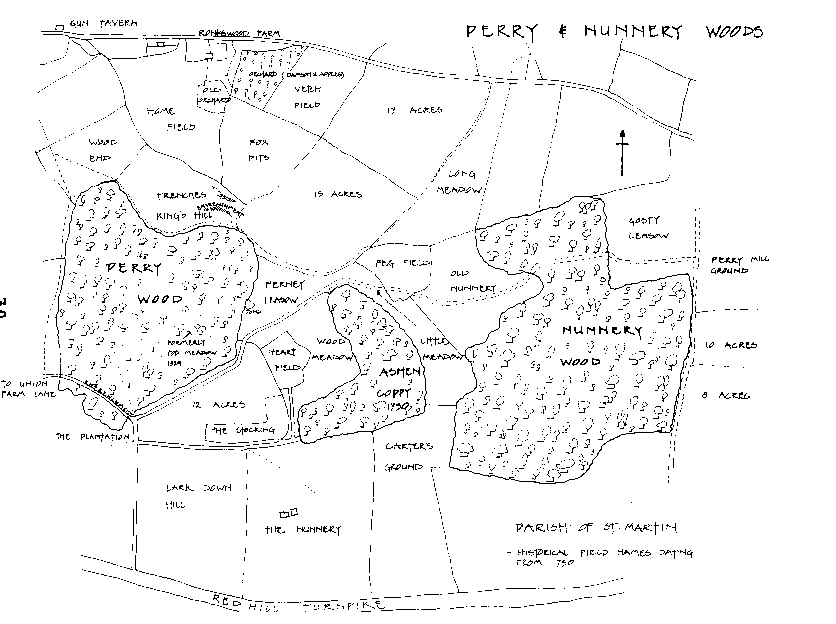
In AD 1003, Wulfstan the Archbishop of York, describes the area as Pyriae, in the parish of St. Martins-without-Worcester. By 1370, a reference to 'Pirywode' in the Annals of the Hospital of St. Wulstan, a site now known as The Commandery, Sidbury, indicated that this wood 'at the Pear Tree' was the last remains of the important manor of Pirie. Since that time other variations of the name have been coined, including Pyrya, Pery, Purry and Perrye.
Nunnery Wood was also owned in pre-Tudor times by St. Wulstan's Hospital under the auspices of the Bishop of Worcester. The wood with its adjoining meadows, together with Nunnery farm, was run by a small Order of local nuns known by the name Whiteladies. The Whiteladies of Nunnery were of an austere Cistercian order who wore white robes and black scapulas. They were granted 51 acres of arable land at Aston - hence the local parish name of White Ladies Aston.
Upon the dissolution of the monasteries by Henry VIII in 1545, the land of the Bishop was broken up and Nunnery and Perry became an endowment to Christ Church College, Oxford, in whose hands most of Nunnery Wood still remains.
Much of the Parish St. Martin’s-without-Worcester, to the east of the City, was within the forest of Feckenham. A forest in Mediaeval times was essentially a mixture of common land, woods, and farms, that was used as a hunting lodge by the Monarch. Thus, it was liable by law to provide venison for the Royal table! From the reign of Edward II, in 1307, to Queen Elizabeth I, in 1603, the Foresters of Feckenham held their court at The Commandery, Sidbury.
Feckenham Forest covered a substantial area of Worcestershire encompassing: Bromsgrove and Redditch, North; Evesham, Pershore and the River Avon, South; Worcester and the River Severn, West; whilst abutting Arden Forest to the East.
During the Middle-ages much of the land was in ‘common use' with peasant farmers enjoying the four common rights of, 'pasture, turbary, piscary and estovers'. This meant that farmers could freely pasture their cattle, cut turf, fish the rivers, and take wood for making into agricultural tools and to burn as fuel.
A system of farming known as ridge-and-furrow has today resulted in many pasture fields having a distinctly undulating surface - or corrugated-iron-roof-like appearance. 'Stock Coppice' to the north of Warndon Wood, and the meadow adjoining Nunnery Wood, are visible examples of the ancient ridge-and-furrow landscape. These features have survived the centuries because modern tractors have never ploughed them. An aerial photograph inside the Countryside Centre, taken in 1941, shows well the areas of ridge-and-furrow around Nunnery Wood.
Curtain areas of the woodland floor within Nunnery display the ridge-and-furrow characteristics, and it is assumed those parts of the wood were once arable farmland which, having long since been abandoned, reverted to oak woodland.
The English Civil War, in September 1651, saw Worcester loyal to King Charles. The city was garrisoned up against Oliver Cromwell’s Parliamentary Army. Parliaments’ forces were chiefly camped in Perry Wood and Red Hill, from where Cromwell's huge siege cannons had range over the City and Fort Royal Hill. Evidence of these encampments, called Cromwell's trenches, is on the meadows of Perry Wood. On some Victorian maps the area is referred to as King's Hill.
Cromwell died seven years to the day after his victory at Worcester, prompting some to say that whilst in Perry Wood he met and made a pact with the Devil! Since Cromwell's day, through to the turn of the century, the wood became infamous as a favourite duelling place for City rivals.
The local naturalist Edwin Lees founded The Worcestershire Naturalists Club with two friends in 1847. Their early records, together with those of the botanists Amphlett and Rea in 1909, provide the first fauna and flora references for the area. They mention that the woods were indigenous of wild apple, pear and cherry, and also the wild service tree. In Perry's boundary hedges grew purging buckthorn, borrer's rose, narrow-leaved everlasting pea, spreading bellflower, spurge laurel and saw-wort - none of which are common today.
Before the introduction of chemical fertilisers and herbicides, the killers of many of our native wildflower species, orchids were widespread. Frog orchids were found nearby in Battenhall, bee orchids on Red Hill, pyramidal orchids in Warndon Wood, and green-winged meadow orchids at the Virgin Tavern, Tolladine Road. The broad-leaved helleborine was found in Nunnery Wood, so too, the early-purple orchid, affectionately called 'Billy Butchers' by some locals.
 The 1900s: Both Perry Wood and Nunnery Wood have been clear-felled of trees this century. Nunnery Wood was clear-felled in 1946, directly after World War II, when the demand for timber rose during the postwar reconstruction years.
Perry Wood once contained a stream and a pond. The stream, long since piped into a culvert, ran from the western edge of Perry towards Shrub Hill, and eventually into the town ditch. The pond called 'Mini Pond' survived until the construction of the Ronkswood estate in 1948. It reputedly brimmed over with 'Nazgels’, a local term for newts! The pond was the site of an air crash during the war, when a training flight disastrously took a nose dive - fortunately with no fatalities!
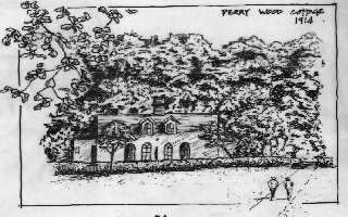
An idyllic white cottage once nestled into the western corner of Perry Wood. The cottage, long demolished, stood on the flat area of scrub at the head of Perry Wood Walk, near the Metal Box factory. Today, at the same site, the deeply cut pathway called the entrenchment leaves the wood. The entrenchment was formerly a farm track connecting Wyldes Lane, then called Union Farm Lane, to Nunnery Farm, which stood at the head of Nunnery Lane.
At the top of the rising entrenchment, outside Perry wood, is the Ronkswood estate. Before the houses, the area was called 'Top Meadow' and was said to be alive with wildflowers, possibly orchids, certainly cowslips. These same fields 'turned blue' with masses of feeding pigeons, and 'swarmed' with large flocks of goldfinches. Nightingales often sang from Perry Wood, and there were always wrens in the undergrowth, known locally as 'Mummy Ruffins'.
Archaeology: Numerous items of archeological interest have so far been recovered in the area. In 1917, an unworked flint was recorded in a ploughed field adjoining Nunnery Wood, and a flint hammer from inside Perry Wood.
Other pieces found from Perry include a disc scraper - a rough and heavy blade dating from 4000 to 2300 BC, and a Plano-convex knife - a flint knife for cutting meat, used during the Bronze Age, 1900 to 500 BC (These last two items are currently held by Worcester City Museum, Foregate Street).

Copyright © 2001
Nick Cripps
Photographs Copyright © 2001 Neil Harris
Portraits Copyright © 2001 Nick Upton
Web Design Copyright © 2001 John Stafford
Worcester Woods Title Page
Help Create WHE
Worcestershire History Encyclopaedia